Division No. 15, Alberta facts for kids
Quick facts for kids
Division No. 15
|
|
|---|---|
|
Census division in Alberta
|
|
| Country | Canada |
| Province | Alberta |
| Area | |
| • Total | 28,400 km2 (11,000 sq mi) |
| Population
(2021)
|
|
| • Total | 37,735 |
| • Density | 1.3287/km2 (3.441/sq mi) |
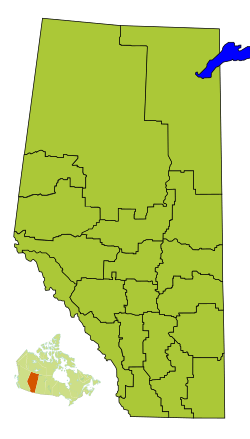
Division No. 15 is a special area in Alberta, Canada. It's called a census division. This means it's a way for the government to organize and count people. Most of this division is in the beautiful Alberta's Rockies mountains. The southern part is in southern Alberta. The biggest town here is Canmore.
Communities in Division No. 15
Division No. 15 is made up of different types of communities. These are called census subdivisions. They include towns, villages, and special areas like national parks.
- Towns
- Summer villages
- Ghost Lake
- Waiparous
- Specialized municipalities
- Municipal districts
- Improvement districts
- Improvement District No. 8
- Improvement District No. 9 (This area includes Banff National Park)
- Improvement District No. 12 (This area includes Jasper National Park)
- Kananaskis Improvement District
- First Nation reserves
Population Information
| Historical population | ||
|---|---|---|
| Year | Pop. | ±% |
| 1991 | 26,359 | — |
| 1996 | 30,800 | +16.8% |
| 2001 | 34,068 | +10.6% |
| 2006 | 34,150 | +0.2% |
| 2011 | 35,983 | +5.4% |
| 2016 | 38,594 | +7.3% |
| 2021 | 37,735 | −2.2% |
Every few years, Statistics Canada counts how many people live in different areas. This is called a census. In 2021, Division No. 15 had a population of 37,735 people. This was a small decrease from 2016, when there were 38,594 people. The division covers a large area of about 28,270 square kilometers. This means there are not many people living in each square kilometer.
See also

- In Spanish: División n.º 15 (Alberta) para niños
 | Laphonza Butler |
 | Daisy Bates |
 | Elizabeth Piper Ensley |


