Fort Washington (Ohio) facts for kids
Quick facts for kids Fort Washington |
|
|---|---|
| Part of the Northwest Territory of the United States | |
| Cincinnati, Ohio | |
 |
|
| Coordinates | 39°05′59″N 84°30′17″W / 39.0998°N 84.5047°W |
| Type | Army Fortress |
| Site history | |
| Built | 1789 |
| Demolished | 1806 |
| Battles/wars | Northwest Indian War |
| Garrison information | |
| Past commanders |
Gen. Arthur St. Clair, Gen. Josiah Harmar, Gen. "Mad" Anthony Wayne, Gen. James Wilkinson |
| Occupants | United States Army |
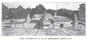
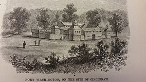
Fort Washington was a strong fort built a long time ago in what is now downtown Cincinnati, Ohio. It was like a big wooden fence with towers, ordered by General Josiah Harmar in 1789. The fort was built near the Ohio River, facing the mouth of the Licking River. It was named to honor President George Washington.
This fort was super important! It was the main place where settlers, soldiers, and supplies gathered before heading into the Northwest Territory. Think of it as a busy hub for people moving into new lands.
Later, in 1803, the fort was moved across the river to Newport, Kentucky. It became known as the Newport Barracks. By 1806, the original spot of Fort Washington was sold off as building lots.
Contents
Fort Washington's Story
Building a New Fort
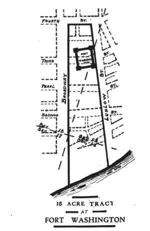
In 1788, a judge named John Cleves Symmes bought a huge piece of land in Ohio. This land was called the Symmes Purchase. The government set aside 15 acres of this land especially for a fort.
So, in the summer of 1789, Fort Washington was built. Its main job was to protect the first small towns in the Symmes Purchase area. These towns included Losantiville, Columbia, and Northbend.
General Arthur St. Clair became the governor of the Northwest Territory in 1787. When he arrived in Losantiville (which is now Cincinnati) in 1790, it was a very small village. It had only two log houses and a few cabins. Major John Doughty and his soldiers were busy finishing Fort Washington. The village had about 150 people, not counting the soldiers.
Just three days after General Harmar moved into Fort Washington, Governor St. Clair arrived. The soldiers and citizens of Losantiville welcomed him with a special ceremony on January 1, 1790.
Fort Washington was quite large, bigger than a modern city block! It was designed to hold up to 1500 soldiers. General Josiah Harmar said it was one of the strongest wooden forts in the western lands. Its walls were two stories high, and it had strong towers at each corner.
Fighting for the Land
Fort Washington was a key spot for sending supplies and soldiers to other forts further north. It played a big role in three important campaigns against Native American groups. These were Harmar's Campaign in 1790, St. Clair's Campaign in 1791, and General "Mad" Anthony Wayne's campaign in 1793-1794.
In 1790, General Harmar led an expedition from Fort Washington. His goal was to fight against Native Americans in northwest Ohio, especially the Miami Indians. Their main city was Kekionga, which is now Fort Wayne, Indiana.
On October 22, 1790, General Harmar's army was attacked by Native American warriors led by Chief Little Turtle. The Native Americans in the Northwest Territory were fighting back, and they had help from the British. Even with Fort Washington nearby, Native American raids sometimes came close to Cincinnati.
In the spring of 1793, Major General Anthony Wayne brought his soldiers down the Ohio River. They set up a camp outside Fort Washington called Hobson's Choice. Later that year, Wayne left Fort Washington and moved his army north. They built another fort called Fort Greene Ville.
The Fort's End
By 1802, Fort Washington was not used as much and was starting to fall apart. Only about 35 soldiers were stationed there. In 1803, a bigger fort called the Newport Barracks took its place. This new fort was built just across the Ohio River in Newport, Kentucky. A powerful person from Newport, James Taylor Jr., had asked his cousin James Madison to put the new fort there.
On February 28, 1806, the government decided to sell the land where the old fort stood. They surveyed the area, dividing it into lots, streets, and avenues. These new streets matched the plan of Cincinnati. The land was then sold to the highest bidders. Records from 1807 show that the fort's boundaries were Fourth Street to the north, Ludlow Street to the east, the Ohio River to the south, and Broadway to the west.
Finding the Fort Again
In October 1952, construction workers found parts of Fort Washington's gunpowder magazine. This was the place where gunpowder was stored. They found it under the northeast corner of Broadway and Third streets. This discovery happened while a parking garage was being built for the Western & Southern Life Insurance Company. Researchers from the Historical and Philosophical Society of Ohio visited the site on October 13, 1952.
The fort's name lives on in Fort Washington Way. This is a section of Interstate 71 and U.S. Route 50 that goes through downtown Cincinnati. It passes right in front of where the old fort used to be. The highway was named in 1958 because the fort's gunpowder storage area had been found nearby.
Today, a special plaque marks the fort's location. You can find it at the Guilford School building, at 421 E 4th St, Cincinnati.
See also
 In Spanish: Fort Washington (Ohio) para niños


