
Fowlea Brook facts for kids
Quick facts for kids Fowlea Brook |
|
|---|---|

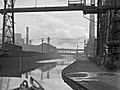
View from Liverpool road
|
|

Fowlea brook within Staffordshire
|
|
| Country | England |
| Counties | Staffordshire |
| Physical characteristics | |
| Main source | 53°03′41″N 2°14′54″W / 53.0614°N 2.2484°W |
| River mouth | Stoke, Staffordshire 53°00′11″N 2°10′45″W / 53.0031°N 2.1793°W |
| Length | 10 km (6.2 mi) |
| Basin features | |
| Basin size | 29 km2 (11 sq mi) |
| Tributaries |
|
| Progression : Fowlea Brook—Trent—Humber | |
The Fowlea Brook is a small river in England. It flows through Staffordshire and the areas around Stoke-on-Trent. This brook is like a smaller stream that feeds into a bigger river called the River Trent. It is about 10 kilometers (6 miles) long.
Contents
Journey of the Fowlea Brook
The Fowlea Brook starts high up near a place called Peacock Hay. From there, it flows towards the south-east through a narrow valley.
As it passes Chatterley, the brook sometimes flows underground in a covered channel. This happens near an industrial area called Chemical Lane.
The brook then comes back into view as it goes past Westport Lake. But it soon goes underground again beneath Longport. Here, another stream called the Scotia Brook joins it.
After that, the Fowlea Brook flows through the Etruria valley, next to the Festival Park site, and then through Cliffe Vale. It even passes through the city center of Stoke-on-Trent, where it is also covered over.
Finally, the brook flows east and joins the River Trent. This meeting point is between Stoke and Fenton, under the A500 road. Part of the brook, from Middleport to where it joins the Trent, is officially called a "main river."
Where the Water Collects
The area where all the rain and water drain into the Fowlea Brook is called its catchment or drainage basin. This area is located between the Ford Green Brook to the north and east, and the Lyme Brook to the south and west. The Fowlea Brook's catchment area covers about 29 square kilometers (11 square miles).
A History of Pollution and Improvement
During the time of the Industrial Revolution, many factories were built along the Fowlea valley. The famous Wedgwood pottery factory was one of them. More factories, like those making bricks and tiles, grew when the Trent and Mersey Canal was built nearby.
Heavy industries also developed in the valley. These included coal mines and large steel works, such as the Shelton Bar steel works, which was very active in the 1960s.
The Impact of Industry
All these factories and industries, along with waste from sewage works, caused a lot of pollution in the Fowlea Brook and the River Trent in the Staffordshire Potteries area. Water from towns like Burslem, Hanley, Tunstall, and Wolstanton all flowed into the brook. Before a sewage treatment plant opened in Tunstall in 1878, there were even threats of legal action because of the ongoing pollution.
In the 1950s, when the pollution was at its worst, the Trent River Board warned that parts of the Trent and the Fowlea Brook in Stoke-on-Trent were "a potential danger to public health." At that time, the Fowlea Brook was the most polluted stream in the Potteries, and no fish could live in it.
Making the Brook Healthier
Thanks to efforts to clean up the brook, its water quality has greatly improved. Today, it is considered to have "moderate ecological quality" under the Water Framework Directive. This is a middle rating on a scale that goes from "high" and "good" to "poor" and "bad."
At Westport Lake, which is now a local nature reserve, the Fowlea Brook is seen as an important natural pathway for wildlife. It helps connect different areas where animals and plants can thrive.
Images for kids
-
Shelton Bar steelworks
_-_geograph.org.uk_-_1629705.jpg)
