Foyil, Oklahoma facts for kids
Quick facts for kids
Foyil, Oklahoma
|
|
|---|---|

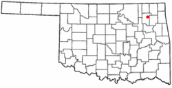
Location of Foyil, Oklahoma
|
|
| Country | United States |
| State | Oklahoma |
| County | Rogers |
| Government | |
| • Type | Town |
| Area | |
| • Total | 0.83 sq mi (2.14 km2) |
| • Land | 0.83 sq mi (2.14 km2) |
| • Water | 0.00 sq mi (0.00 km2) |
| Elevation | 728 ft (222 m) |
| Population
(2020)
|
|
| • Total | 368 |
| • Density | 444.44/sq mi (171.63/km2) |
| Time zone | UTC-6 (Central (CST)) |
| • Summer (DST) | UTC-5 (CDT) |
| ZIP code |
74031
|
| Area code(s) | 539/918 |
| FIPS code | 40-27600 |
| GNIS feature ID | 2412650 |
Foyil is a small town located in Rogers County, Oklahoma, in the United States. It was named after Alfred Foyil, who owned land in the area and became the town's first postmaster. In 2020, the town had a population of 368 people. This was an increase from 344 people counted in 2010, and 234 people in 2000.
Where is Foyil Located?
Foyil is about 10 miles (16 km) northeast of Claremore. It is also about 9 miles (14 km) southwest of Chelsea. The town is situated on Oklahoma State Highway 66. This road was once part of the famous U.S. Route 66. Foyil is just south of where Highway 66 meets Oklahoma State Highway 28.
The United States Census Bureau states that Foyil covers a total area of about 0.4 square miles (1.0 km²). All of this area is land.
People Living in Foyil
| Historical population | |||
|---|---|---|---|
| Census | Pop. | %± | |
| 1920 | 109 | — | |
| 1930 | 184 | 68.8% | |
| 1940 | 170 | −7.6% | |
| 1950 | 146 | −14.1% | |
| 1960 | 127 | −13.0% | |
| 1970 | 164 | 29.1% | |
| 1980 | 191 | 16.5% | |
| 1990 | 86 | −55.0% | |
| 2000 | 234 | 172.1% | |
| 2010 | 344 | 47.0% | |
| 2020 | 368 | 7.0% | |
| U.S. Decennial Census | |||
In the year 2000, there were 234 people living in Foyil. These people lived in 97 households, and 68 of these were families. The town had about 657 people per square mile (254 people per km²). There were 112 homes in total.
Most of the people in Foyil were White (about 79%). About 9% were Native American. A small number were from other backgrounds or mixed races. About 2.5% of the population identified as Hispanic or Latino.
About 23.7% of the households had children under 18 years old. More than half (57.7%) were married couples living together. About 11.3% of households were led by a female without a husband present. The average household had 2.41 people, and the average family had 2.83 people.
The population was spread out by age. About 21.8% of the people were under 18 years old. About 15.4% were 65 years or older. The average age in the town was 44 years.
See also
 In Spanish: Foyil (Oklahoma) para niños
 | George Robert Carruthers |
 | Patricia Bath |
 | Jan Ernst Matzeliger |
 | Alexander Miles |

