Franz Schrader facts for kids
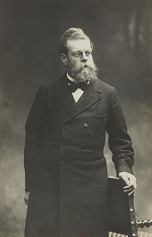
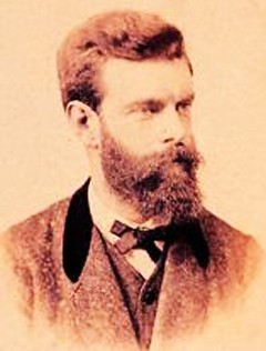
Jean Daniel François Schrader (born January 11, 1844 – died October 18, 1924), known as Franz Schrader, was a French explorer, mapmaker, and artist. He loved mountains, especially the Pyrenees mountain range between France and Spain. He was a great mountaineer (someone who climbs mountains), a geographer (someone who studies the Earth's surface), and a cartographer (someone who makes maps). He also painted beautiful landscapes. Schrader made a huge difference in mapping the Pyrenees and was highly respected by other mountain lovers.
Contents
His Life and Adventures
Franz Schrader was born in Bordeaux, France. His father was from Prussia, and his mother was French. He was also related to famous geographers Élisée and Onésime Reclus. From a young age, Franz was very good at drawing.
His father wanted him to work in an office, but Franz found a different job that gave him more time to read and learn about science.
In 1866, while visiting a friend in Pau, Franz saw the amazing mountains of the Pyrenees. It was a life-changing moment for him! He felt a strong desire to explore them. He read exciting stories by other explorers like Ramond de Carbonnières and Henry Russell, which made his passion for mountains even stronger.
Franz spent most of his free time hiking in the mountains. He collected thousands of notes and observations to help him make accurate maps. He also painted many stunning pictures of the Pyrenees and the Alps. He became very skilled in topography, which is the study of the shapes and features of the Earth's surface.
Mapping the Mountains
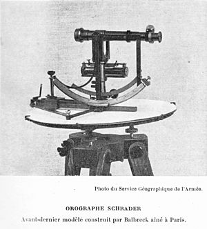
Franz Schrader worked hard to learn about cartography (mapmaking). He wanted to create a large, detailed map of the Pyrenees. To make his work easier in the tough mountain terrain, he invented a special tool called the orograph in 1873.
His first big map was of the Gavarnie-Mont-Perdu area in 1874. This map was so good that it caused a sensation! People were amazed by its detail and accuracy. The French Alpine Club praised him, calling him a "first rank topographer." In 1876, he helped start the Bordeaux section of the Club alpin français (French Alpine Club) and became its first president.
In 1877, Franz moved to Paris. He got a job as a geographer at a famous publishing company called Librairie Hachette. This allowed him to turn his passion for geography and mapping into his profession. He also taught geography and became an editor for the French Alpine Club's magazine.
On August 11, 1878, Franz Schrader, with guide Henri Passet, was the first known person to climb the Grand Batchimale mountain (3,176 meters high). This peak was later renamed pic Schrader in his honor!
In 1880, he became the director of cartography for Hachette. He wanted to create maps that were even better than the best German maps of his time.
Franz Schrader was also a big supporter of mountain art. In 1897, he gave a famous speech about the beauty of mountains. This speech led to the creation of the Société des Peintres de Montagne (Society of Mountain Painters).
From 1901 to 1904, he was the president of the French Alpine Club. He also helped create the famous Guides Joanne travel guides, which later became the Guides bleus.
Franz Schrader passed away in Paris in 1924. In 1927, his body was moved to a special tomb on a slope of the beautiful cirque de Gavarnie, a place he loved so much. The scientific group he created in the French Alpine Club and the Society of Mountain Painters still exist today.
The Orograph
The orograph was a clever tool invented by Franz Schrader in the 1870s. Its name comes from ancient Greek words meaning "mountain" and "to write." It was designed to take very precise measurements of mountains.
One of the best things about the orograph was how easy it was to carry. It was small enough to be taken on difficult mountain climbs.
This device had a kind of telescope that the user would point at different parts of the mountain. This telescope was connected to a pen. As the telescope moved, the pen would draw lines onto a paper disk. This created an instant map or graph of the mountain's shape. It was a revolutionary tool for mapmakers!
His Amazing Maps and Books
Franz Schrader created many important maps and books during his life.
Atlases
- He worked on and directed several major atlases, which are collections of maps.
- Some of his famous atlases include the Atlas de géographie moderne (1890) and the Atlas universel de géographie (1923).
- He also co-authored the Atlas classique de géographie ancienne et moderne in 1905.
Topographical Maps
- In 1874, he made a detailed map of the Gavarnie-Mont Perdu area.
- He created a large map of the entire Pyrenees mountain range between 1886 and 1891.
- In 1914, he made an even more detailed map of Gavarnie-Mont Perdu.
Paintings
Franz Schrader was also a talented landscape painter. He created hundreds of paintings, including:
- The Cirque de Gavarnie
- The Great Waterfall of Gavarnie
- The Frozen Lake of Mont-Perdu
- The Maladetta Massif
- Panorama of Mont Blanc (shown at the 1900 World's Fair)
- The Pic du Midi d'Ossau
- The Vignemale
Honours
- In 1889, he was made a Knight of the Légion d'honneur, a very important French award.
- In 1928, after he passed away, he received the Grand Gold Medal from the Geographical Society of Paris.

See also
 In Spanish: Franz Schrader para niños
 | Roy Wilkins |
 | John Lewis |
 | Linda Carol Brown |


