Frazer, Montana facts for kids
Quick facts for kids
Frazer, Montana
|
|
|---|---|

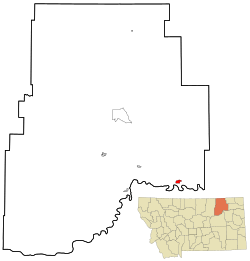
Location of Frazer, Montana
|
|
| Country | United States |
| State | Montana |
| County | Valley |
| Area | |
| • Total | 1.65 sq mi (4.27 km2) |
| • Land | 1.62 sq mi (4.20 km2) |
| • Water | 0.03 sq mi (0.07 km2) |
| Elevation | 2,060 ft (630 m) |
| Population
(2020)
|
|
| • Total | 354 |
| • Density | 218.11/sq mi (84.23/km2) |
| Time zone | UTC-7 (Mountain (MST)) |
| • Summer (DST) | UTC-6 (MDT) |
| ZIP code |
59225
|
| Area code(s) | 406 |
| FIPS code | 30-29275 |
| GNIS feature ID | 2408256 |
Frazer is a small community in Valley County, Montana, United States. It's known as a census-designated place (CDP), which means it's a special area defined by the government for counting people. Frazer is located inside the Fort Peck Indian Reservation. It's also about 80 miles (129 km) from the Canadian border. In 2020, about 354 people lived there.
Frazer was first set up as a train station in 1888. This happened when the St. Paul, Minneapolis & Manitoba Railway built its tracks through the area. A post office was opened in Frazer in 1907.
Geography of Frazer
Frazer is a small place, covering about 1.7 square miles (4.4 square kilometers). Most of this area is land. A very small part, about 0.04 square miles (0.1 square kilometers), is water.
Population and People
The number of people living in Frazer changes over time. In 2020, the population was 354.
| Historical population | |||
|---|---|---|---|
| Census | Pop. | %± | |
| 2020 | 354 | — | |
| U.S. Decennial Census | |||
Getting Around Frazer
Even though trains pass through Frazer, they don't stop there. The famous Amtrak train called the Empire Builder travels on the BNSF tracks through the town. This train goes all the way from Seattle or Portland to Chicago. If you want to catch a train, the closest station is in Wolf Point. Wolf Point is about 19 miles (31 km) east of Frazer.
Education in Frazer
Students in Frazer go to the Frazer School. This school teaches kids from kindergarten all the way through 12th grade. The sports teams at Frazer High School are called the Bearcubs. In Spanish: Frazer (Montana) para niños
 | Charles R. Drew |
 | Benjamin Banneker |
 | Jane C. Wright |
 | Roger Arliner Young |

