Freedom, Pennsylvania facts for kids
Quick facts for kids
Freedom, Pennsylvania
|
|
|---|---|

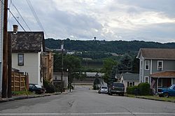
Typical scene on one of the borough's steep streets, with the Conway Yard and the Ohio River visible in the distance
|
|
| Motto(s):
Yours, Mine, Ours
|
|

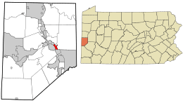
Location in Beaver County and the U.S. state of Pennsylvania.
|
|
| Country | United States |
| State | Pennsylvania |
| County | Beaver |
| Settled | 1832 |
| Incorporated | 1838 |
| Government | |
| • Type | Borough Council |
| Area | |
| • Total | 0.74 sq mi (1.91 km2) |
| • Land | 0.60 sq mi (1.56 km2) |
| • Water | 0.13 sq mi (0.35 km2) |
| Elevation | 827 ft (252 m) |
| Population
(2020)
|
|
| • Total | 1,496 |
| • Density | 2,476.82/sq mi (956.56/km2) |
| Time zone | UTC-5 (Eastern (EST)) |
| • Summer (DST) | UTC-4 (EDT) |
| Zip code |
15042
|
| Area code(s) | 724, 878 |
| FIPS code | 42-27712 |
Freedom is a small town, called a borough, located in Beaver County, Pennsylvania. It sits right along the Ohio River. In 2020, about 1,496 people lived there. Freedom is about 25 miles (40 km) northwest of Pittsburgh and is part of the larger Pittsburgh area. It started as a place where steamboats were built. Later, its main businesses included making oil, caskets, and monuments.
Contents
History of Freedom: From Harmony to a New Town
Freedom has an interesting past, especially linked to a group called the Harmony Society.
The Harmony Society and Their Journey
In 1824, the Harmony Society moved back to Pennsylvania from Indiana. They settled in a place now known as Ambridge, which is about five miles (8 km) up the Ohio River. One reason they left Indiana was because they were bothered for their strong beliefs against slavery. This belief is called abolitionism.
Their new home was in Beaver County, along the Ohio River. Here, they founded a town they called "Ökonomie," which is now famous as Old Economy Village. The Harmony Society became well-known around the world for their religious dedication and how successful they were economically.
How Freedom Got Its Name
The Harmonites were against slavery. They started putting up signs along the Ohio River that simply said "FREEDOM." Because of these signs, the area where Freedom is today began to be called "Freedom" on maps used by steamboat captains.
Founding of the Borough of Freedom

The community of Freedom was officially started in 1832. It was founded by Jonathan Betz and Stephen Phillips. They owned a business that built steamboats. They bought about 100 acres (0.4 km2) of land for $2,000 from General Abner Lacock.
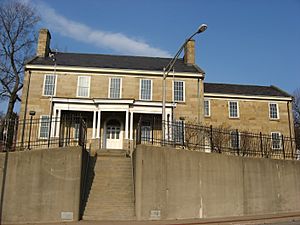
Simon Meredith planned out the original village. All the streets, lots, and alleys were designed to be perfect for the steamboat-building business. This was the only business in town at the time. Later, they bought another 39 acres (0.16 km2) from Captain William Vicary for $2,500. Captain Vicary kept some land, including a stone house. Today, his house is a famous local landmark. It is even listed on the National Register of Historic Places.
About 150 people first moved to Freedom, and the town grew very quickly. The town was planned on a Tuesday, and by the next Saturday, fourteen houses were already built! By 1833, Freedom had 40 homes, 47 families, and about 320 people. Building boats and making alcohol were the two main businesses.
By 1837, Freedom's population had grown to about 600 people, with 100 homes. New businesses included a metal foundry and a large sawmill. There was also a big distillery and flour mill.
Freedom Grows: Absorbing Saint Clair Borough
In 1896, a nearby town called Saint Clair was joined with Freedom. Saint Clair Borough is now what we call Freedom's second ward. It was originally planned by Captain William Vicary and was often called Vicary or Vicary Extension.
Geography: Where is Freedom Located?
Freedom is located at 40°41′4″N 80°15′6″W / 40.68444°N 80.25167°W. It shares borders with a few other towns. To the northwest is East Rochester. To the east and northeast is New Sewickley Township. To the south is Conway. Freedom is also right across the Ohio River from Monaca.
The United States Census Bureau says that Freedom covers a total area of about 0.7 square miles (1.8 km2). Most of this area, about 0.6 square miles (1.6 km2), is land. The rest, about 0.1 square miles (0.26 km2), is water, mainly from the Ohio River.
Population Changes in Freedom
| Historical population | |||
|---|---|---|---|
| Census | Pop. | %± | |
| 1840 | 384 | — | |
| 1850 | 524 | 36.5% | |
| 1860 | 533 | 1.7% | |
| 1870 | 634 | 18.9% | |
| 1880 | 623 | −1.7% | |
| 1890 | 704 | 13.0% | |
| 1900 | 1,783 | 153.3% | |
| 1910 | 3,060 | 71.6% | |
| 1920 | 3,452 | 12.8% | |
| 1930 | 3,227 | −6.5% | |
| 1940 | 3,227 | 0.0% | |
| 1950 | 3,000 | −7.0% | |
| 1960 | 2,895 | −3.5% | |
| 1970 | 2,643 | −8.7% | |
| 1980 | 2,272 | −14.0% | |
| 1990 | 1,897 | −16.5% | |
| 2000 | 1,763 | −7.1% | |
| 2010 | 1,569 | −11.0% | |
| 2020 | 1,496 | −4.7% | |
| 2021 (est.) | 1,479 | −5.7% | |
| Sources: | |||
The population of Freedom has changed over many years. In 1840, there were 384 people. The town grew a lot in the early 1900s, reaching over 3,000 people by 1910. Since then, the population has slowly decreased. In 2020, the population was 1,496 people.
Education: Schools in Freedom
Students in Freedom attend schools that are part of the Freedom Area School District. The schools serving the borough are:
- Freedom Area Elementary School – for students in grades K–4
- Freedom Area Middle School – for students in grades 5–8
- Freedom Area Senior High School – for students in grades 9–12
Notable People from Freedom
Some well-known people have connections to Freedom:
- Dominic DeNucci – a famous professional wrestler
- Josh Sharpless – a former Major League Baseball relief pitcher
- John Warhola – an artist and the brother of the famous artist Andy Warhol. John helped create The Andy Warhol Museum and the Andy Warhol Museum of Modern Art.
See also
 In Spanish: Freedom (Pensilvania) para niños
 | Claudette Colvin |
 | Myrlie Evers-Williams |
 | Alberta Odell Jones |

