
Freedom Riders National Monument facts for kids
Quick facts for kids Freedom Riders National Monument |
|
|---|---|

The former Greyhound station in October 2017
|
|
| Location | Anniston, Alabama |
| Area | 7.83 acres |
| Website | Freedom Riders National Monument |
| Designated | January 12, 2017 |
| Lua error in Module:Location_map at line 420: attempt to index field 'wikibase' (a nil value). | |
The Freedom Riders National Monument is a special place in Anniston, Alabama. It was created by President Barack Obama in January 2017. This monument helps us remember the brave Freedom Riders and their fight for equal rights during the Civil Rights Movement. The National Park Service takes care of this important site.
The Freedom Riders National Monument was one of three National Monuments created by President Obama on January 12, 2017. The others were the Birmingham Civil Rights National Monument and the Reconstruction Era National Historical Park.
Contents
Important Locations at the Monument


The Freedom Riders National Monument includes two main spots. One is in downtown Anniston, and the other is a bit outside of town.
The Greyhound Bus Station
One part of the monument is the old Greyhound bus station in Anniston. On May 14, 1961, a group of Freedom Riders arrived here. These riders were Black and white people traveling together. They wanted to end racial segregation on buses that traveled between states.
A large crowd attacked their bus at this station. The mob cut the bus's tires and threw rocks. They broke the bus windows. Even after the bus drove away, the crowd followed it. Today, a colorful mural and signs on a nearby wall tell the story of what happened here. The old Greyhound station is now owned by the U.S. government. It is one of nine important places on the Anniston Civil Rights and Heritage Trail. A historical marker was put up here in 2016.
The National Park Service and the city of Anniston plan to open the building to visitors in the future.
The Bus Burning Site
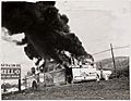
The second part of the monument is where the bus was burned. This spot is about 6 miles (10 km) outside Anniston, along Old Birmingham Highway. The bus had to stop here because its tires were flat from the attack at the station.
The same crowd that followed the bus kept attacking it. They threw a burning rag into the bus, and it caught fire very quickly. As passengers tried to escape, the crowd attacked them. A photographer named Joseph "Little Joe" Postiglione took a picture of the burning bus. This photo became a famous image of the Civil Rights Movement. A historical marker was placed here in 2007 to remember the event.
In 2010, some land around the bus burning site was given to Calhoun County. The idea was to create a memorial park there. Plans include a walking path with signs explaining the history. There might even be a statue of Hank Thomas, a Freedom Rider who survived the attack. He was given water by a local resident named Janie Forsythe. The National Park Service is working with local groups to plan how to teach visitors about this site. A sign for the future park was put up in 2012. It was damaged by vandals but quickly fixed.
Today, homes surround the site where the bus was burned.
History of the Monument's Creation
The idea to make this a national monument grew after important leaders visited the site. In October 2016, Interior Secretary Sally Jewell and National Park Service Director Jonathan Jarvis came to see the locations.
Local leaders in Anniston and Calhoun County were very happy about the monument's creation. They had worked hard to make it happen. Other supporters included Senator Richard Shelby and Representative Mike Rogers.
A special ceremony to dedicate the monument took place on May 13, 2017. This was one day before the 56th anniversary of the bus attack. People came from far away to attend. Former Freedom Rider Hank Thomas, who was on the bus that day, gave a speech. An early visitor center has been set up in Anniston City Hall. Here, visitors can get a special National Parks passport stamp.
In 2017, the National Park Service asked the public for ideas on how to plan and explain the monument. Federal and local leaders started making official plans later that year.
Images for kids
-
Joe Postiglione's photograph of the burning bus

