
Freelandville, Indiana facts for kids
Quick facts for kids
Freelandville
Freelandsville |
|
|---|---|

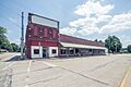
Downtown Freelandville
|
|

Location in Knox County, Indiana
|
|
| Country | United States |
| State | Indiana |
| County | Knox |
| Township | Widner |
| Named for | Dr. John T. Freeland |
| Area | |
| • Total | 5.57 sq mi (14.41 km2) |
| • Land | 5.57 sq mi (14.41 km2) |
| • Water | 0.00 sq mi (0.00 km2) |
| Elevation | 574 ft (175 m) |
| Population
(2020)
|
|
| • Total | 617 |
| • Density | 110.87/sq mi (42.81/km2) |
| Time zone | UTC-5 (EST) |
| • Summer (DST) | UTC-4 (EDT) |
| ZIP code |
47535
|
| Area code(s) | 812 |
| FIPS code | 18-25810 |
| GNIS feature ID | 434813 |
Freelandville (sometimes called Freelandsville) is a small community in Knox County, Indiana, United States. It is an unincorporated community, meaning it does not have its own local government. It is also a census-designated place, which means it has a defined area for counting people. In 2020, about 617 people lived there.
Contents
Where is Freelandville Located?
Freelandville is in the northeastern part of Knox County. You can find it where two main roads, State Road 58 and State Road 159, meet.
It is about 5 miles (8 km) west of Westphalia. It is also 6 miles (10 km) north of Bicknell. Vincennes, the main city in Knox County, is about 20 miles (32 km) northeast. The U.S. Census Bureau says Freelandville covers an area of about 14.2 square kilometers (5.5 square miles). All of this area is land.
Who Lives in Freelandville?
In 2018, it was estimated that about 890 people lived in Freelandville. Most of the residents, about 98.5%, were white. About 1.5% of the people were of two or more races.
Freelandville's Early History
The first person to settle in this area was John Widner. He arrived in Knox County in 1798. In 1804, he settled on land about two and a half miles northwest of where Freelandville is today.
William Polk, who was the uncle of future U.S. President James Polk, also settled nearby in 1808. In 1812, a fort called Fort Widner was built. This fort helped protect the settlers from Native Americans during the War of 1812.
How Freelandville Got Its Name
Even though English settlers came first, many immigrants from Germany moved to the area in the mid-1800s. They were looking for cheap land and work on the Wabash & Erie Canal. Many of these German settlers came from Prussia.
The German settlers first called the place "Bethlehem" or "Kreuzweg", which means "crossroads." The town was officially planned out on July 31, 1866, by John Ritterskamp. The people living there decided to name the town "Freelandsville." This was to honor Dr. John F. Freeland, a well-known local doctor. Old maps still show the name Freelandsville, and some local people still use this name. It is not clear when the shorter spelling, Freelandville, became more common.
Kixmiller's Store
Kixmiller's Store was an important building in Freelandville. It was located on the north side of the main intersection of Highways 58 and 159. This store was added to the National Register of Historic Places in 1978. Sadly, the building was partly torn down on February 20, 2017, because it had become very old and damaged.
Freelandville School History
The very first school in the area was held in 1808 at John Widner's home. The first school building in Freelandville was built around 1850, even before the town was officially planned. Because more and more people were moving to the area, a second, two-story school building was built in 1874.
Changes to Local Schools
In 1963, the high schools in the area joined together to form the North Knox School Corporation. This meant that all the local high schools, including those from Bicknell, Freelandville, Bruceville, Oaktown, Edwardsport, Sandborn, Westphalia, and Emison, moved to a central location in Edwardsport. The elementary schools stayed in their original buildings, except for Edwardsport's elementary students, who moved to the Freelandville school.
The local elementary schools stayed open until 1973. At that time, a new high school building was opened. The old high school building and new buildings in Bicknell and Bruceville then became elementary schools.
The sports teams from Freelandville School were known as the "Fightin' Dutch." Their school colors were blue and white.
The Story of Happy Street
When John Ritterskamp first planned Freelandville, he named one street "Henry Street" after a family member. He named many streets this way. However, the people living on Henry Street started calling it "Happy Street." They did this because of the friendly people and children who lived there. No one knows exactly when the nickname started, but it is believed to have been called "Happy Street" since at least the 1930s.
In the early 1980s, the Freelandville Improvement Club decided to put up street signs in town, as there hadn't been any before. It's funny, but there is no street sign for Happy Street today. Any time a sign was put up, it was stolen!
The people living on Henry Street successfully asked to have the name officially changed to "Happy Street." This street runs for one block. When it crosses State Road 159, its name changes back to Henry Street.
Images for kids
-
Cafe and Electronics Building (Photo from Small Town Indiana photo survey)
-
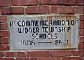
Stone marker at the location of the Freelandville School


See also
 In Spanish: Freelandville (Indiana) para niños
