Freeman, Missouri facts for kids
Quick facts for kids
Freeman, Missouri
|
|
|---|---|

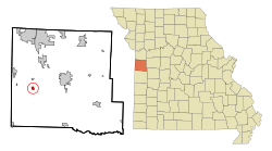
Location of Freeman, Missouri
|
|
| Country | United States |
| State | Missouri |
| County | Cass |
| Area | |
| • Total | 0.88 sq mi (2.28 km2) |
| • Land | 0.86 sq mi (2.22 km2) |
| • Water | 0.02 sq mi (0.05 km2) |
| Elevation | 915 ft (279 m) |
| Population
(2020)
|
|
| • Total | 475 |
| • Density | 552.97/sq mi (213.59/km2) |
| Time zone | UTC-6 (Central (CST)) |
| • Summer (DST) | UTC-5 (CDT) |
| ZIP code |
64746
|
| Area code(s) | 816 |
| FIPS code | 29-25894 |
| GNIS feature ID | 2394820 |
Freeman is a small city in Cass County, Missouri, United States. It is located in the western part of Missouri. In 2020, about 475 people lived there. Freeman is also part of the larger Kansas City metropolitan area, which is a big group of cities and towns.
Contents
History of Freeman
When Was Freeman Founded?
Freeman was officially planned and marked out on a map in 1871. This process is called "platting." The city was named after an important railroad official. A post office opened in Freeman in the same year, 1871. It has been helping people send and receive mail ever since.
Geography of Freeman
What is the Area of Freeman?
According to the United States Census Bureau, the city of Freeman covers a total area of about 0.88 square miles (2.28 square kilometers). Most of this area, about 0.86 square miles (2.22 square kilometers), is land. A small part, about 0.02 square miles (0.05 square kilometers), is water.
People of Freeman
How Many People Live in Freeman?
The number of people living in Freeman has changed over the years. Here is a look at the population from different census counts:
| Historical population | |||
|---|---|---|---|
| Census | Pop. | %± | |
| 1880 | 309 | — | |
| 1890 | 279 | −9.7% | |
| 1900 | 260 | −6.8% | |
| 1910 | 251 | −3.5% | |
| 1920 | 299 | 19.1% | |
| 1930 | 279 | −6.7% | |
| 1940 | 302 | 8.2% | |
| 1950 | 309 | 2.3% | |
| 1960 | 391 | 26.5% | |
| 1970 | 417 | 6.6% | |
| 1980 | 485 | 16.3% | |
| 1990 | 480 | −1.0% | |
| 2000 | 521 | 8.5% | |
| 2010 | 482 | −7.5% | |
| 2020 | 475 | −1.5% | |
| U.S. Decennial Census | |||
Freeman's Population in 2010
In 2010, the census counted 482 people living in Freeman. These people lived in 178 different homes, and 125 of these were families. The city had about 560 people per square mile. There were 215 housing units, which are places where people can live.
Most of the people in Freeman in 2010 were White, making up 97.3% of the population. A small number of people were African American, Native American, or from other backgrounds. About 0.8% of the population was Hispanic or Latino.
In 2010, about 40% of the homes had children under 18 living there. The average age of people in the city was about 31.4 years old. About 29% of residents were under 18. Also, 11% of the people were 65 years old or older. The city had a nearly even number of males and females.
See also
 In Spanish: Freeman (Misuri) para niños

