Frenchman, Nevada facts for kids
Quick facts for kids
Frenchman, Nevada
|
|
|---|---|
|
Former community
|
|

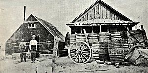
Frenchman Station, around 1910
|
|
| Country | United States |
| State | Nevada |
| County | |
| Elevation | 4,157 ft (1,267 m) |
| Time zone | UTC-8 (Pacific (PST)) |
| • Summer (DST) | UTC-7 (PDT) |
| GNIS feature ID | 857995 |
Frenchman was once a small community in Churchill County, Nevada, United States. It was also known as Frenchman's Station or Bermond. You could find Frenchman along U.S. Route 50, about 30 miles (48 km) east-southeast of Fallon. Today, it is considered a ghost town.
Contents
What Was Frenchman?
Frenchman started in 1904 as a place where stagecoaches could stop. It got its name from Aime "Frenchy" Bermond, who was an immigrant from France. "Frenchy's" was a welcome break for people, animals, and goods. They were all traveling between towns like Fallon, Fairview, and Wonder in the early 1900s.
A Busy Stop for Travelers
This important stop offered many services. Travelers could find a place to stay in a hotel. There was also a restaurant to get food. Saloons provided drinks, and stables were available for horses. It was a busy and helpful spot for anyone on a long journey through Nevada.
Why Did Frenchman Disappear?
The community of Frenchman did not last forever. In 1985, the U.S. Navy bought the land where Frenchman was located. This was because the area was very close to a large military training zone called Dixie Valley.
Buildings Taken Down
Two years after the Navy bought the land, in 1987, the remaining buildings of Frenchman were taken down. This marked the end of the community. Today, there are no buildings left standing from the old Frenchman's Station.
Frenchman in a Book
The former community of Frenchman is mentioned in a famous book. It appears in Blue Highways by William Least Heat-Moon. The book even includes a picture of two people, Margaret and Laurie Chealander, at Frenchman.
 | Bayard Rustin |
 | Jeannette Carter |
 | Jeremiah A. Brown |


