Friar Street, Reading facts for kids

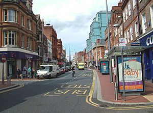
Friar Street looking west in 2007
|
|
| Former name(s) | New Street |
|---|---|
| Location | Reading, Berkshire, UK |
| Postal code | RG1 |
| Coordinates | 51°27′23.95″N 0°58′25.03″W / 51.4566528°N 0.9736194°W |
Friar Street is a busy road in Reading, a town in England. It runs next to Broad Street. You can get between them using smaller roads like Union Street and Queen Victoria Street. At one end of Friar Street, you'll find the Greyfriars Church. At the other end are the Town Hall and St Laurence's Church.
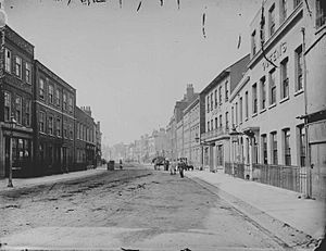
A Look Back in Time
In 1997, workers were digging on Friar Street for a new part of the Marks and Spencer store. They found layers of old buildings deep underground. Some of these buildings were from the 13th century, which is over 700 years ago! This shows how old the area is.
A famous theatre called the Royal County Theatre used to be on Friar Street. It was built in 1895 and designed by Frank Matcham. Sadly, it burned down in 1937.
In 1963, a large Sainsbury's supermarket opened on the street. This big new store caused many of the smaller, older shops to close down.
The Story of Friars Walk
The Friars Walk shopping centre was built at the western end of Friar Street. It opened to shoppers in 1973 or 1974.
For about ten years, from 2009 to 2019, the shopping centre was empty and unused. It was known as "The Mall" for six of those years, until 2018. During this time, it was used for fun activities like airsoft games and immersive zombie survival games. These games let people pretend to be in a zombie movie!
The company that ran the zombie games, Zed Events, moved to a new place. This allowed Friars Walk to be torn down as part of a big building project called the Reading Station Hill development. On August 1, 2019, some scaffolding fell down at the demolition site.
 | DeHart Hubbard |
 | Wilma Rudolph |
 | Jesse Owens |
 | Jackie Joyner-Kersee |
 | Major Taylor |


