
Gail, Texas facts for kids
Quick facts for kids
Gail, Texas
|
|
|---|---|

Borden County Courthouse in Gail
|
|

Gail, Texas
Location in Texas

Gail, Texas
Location in the United States
|
|
| Country | United States |
| State | Texas |
| County | Borden |
| Area | |
| • Total | 2.02 sq mi (5.23 km2) |
| • Land | 2.01 sq mi (5.21 km2) |
| • Water | 0.008 sq mi (0.02 km2) |
| Elevation | 2,556 ft (779 m) |
| Population
(2020)
|
|
| • Total | 249 |
| • Density | 123.3/sq mi (47.61/km2) |
| Time zone | UTC-6 (Central (CST)) |
| • Summer (DST) | UTC-5 (CDT) |
| ZIP codes |
79738
|
| Area code(s) | 806 |
Gail is a small community in Borden County, Texas, USA. It's the main town, or county seat, of Borden County. You can find it where two roads meet: U.S. Route 180 and Farm to Market Road 669. In 2020, about 249 people lived here.
The town and the county are both named after Gail Borden, Jr. He was famous for inventing condensed milk, which is milk with most of the water removed.
On the edge of town, there's a place called Gail Mountain. Every year in November, people light up a star on top of Gail Mountain for Christmas.
Contents
History of Gail
Gail was started in 1891 when Borden County was first organized. It has always been the county seat, which means it's where the county government is located. For a while, Borden County didn't have many people.
In 1903, something called the "War of Ribbons" happened. This was a conflict over land. Ranchers who were already living there wore blue ribbons to show who they were. New settlers wore red ribbons.
By 1910, Gail had more than 700 people. Even though the population dropped a bit by 1912, Gail was still the most important place in Borden County for business and government.
However, changes in farming and the Great Depression made things harder for the town. By 1936, only 250 people lived in Gail. By 1980, it was down to about 190. The latest count in 2020 showed 249 residents.
The Old Jailhouse
The Borden County Jail opened in 1896. It cost $4,500 to build. Its outside walls were 2 feet thick and made of stone from Gail Mountain. The cell walls and floor had strong steel plates.
In 1956, a funny thing happened. Two prisoners didn't want to go into their cell because they saw a rattlesnake sleeping inside! A special marker was placed outside the jail in 1967 to remember its history.
John R. "Rich" Anderson, who owned a large ranch near Gail, won an award in 1992. It was the National Cattleman's Association Environmental Stewardship Award. This award recognized his efforts to protect the environment on his ranch.
Where is Gail?
Gail is located right in the middle of Borden County. U.S. Route 180 goes through the town. If you go east on this road, it's about 31 miles to Snyder. If you go west, it's 31 miles to Lamesa.
Big Spring is about 40 miles south on FM 669. Lubbock is about 72 miles north.
Gail covers an area of about 5.2 square kilometers (2.0 square miles). Only a tiny part of this area, about 0.02 square kilometers (0.0077 square miles), is covered by water.
Gail's Climate
Gail has a semiarid steppe climate. This means it's a dry area, but not a true desert. It gets some rain, but not a lot.
| Climate data for Gail, Texas, 1991–2020 normals, extremes 1912–present | |||||||||||||
|---|---|---|---|---|---|---|---|---|---|---|---|---|---|
| Month | Jan | Feb | Mar | Apr | May | Jun | Jul | Aug | Sep | Oct | Nov | Dec | Year |
| Record high °F (°C) | 87 (31) |
92 (33) |
98 (37) |
104 (40) |
111 (44) |
116 (47) |
113 (45) |
112 (44) |
106 (41) |
103 (39) |
91 (33) |
85 (29) |
116 (47) |
| Mean maximum °F (°C) | 78.1 (25.6) |
82.0 (27.8) |
88.5 (31.4) |
93.9 (34.4) |
99.9 (37.7) |
102.7 (39.3) |
102.5 (39.2) |
101.7 (38.7) |
97.3 (36.3) |
92.4 (33.6) |
82.9 (28.3) |
76.8 (24.9) |
105.7 (40.9) |
| Mean daily maximum °F (°C) | 57.1 (13.9) |
62.0 (16.7) |
70.1 (21.2) |
78.8 (26.0) |
85.6 (29.8) |
91.4 (33.0) |
93.6 (34.2) |
92.9 (33.8) |
85.5 (29.7) |
77.2 (25.1) |
65.7 (18.7) |
57.4 (14.1) |
76.4 (24.7) |
| Daily mean °F (°C) | 44.6 (7.0) |
48.8 (9.3) |
56.4 (13.6) |
64.4 (18.0) |
72.7 (22.6) |
79.3 (26.3) |
81.9 (27.7) |
81.2 (27.3) |
73.9 (23.3) |
64.3 (17.9) |
53.1 (11.7) |
45.3 (7.4) |
63.8 (17.7) |
| Mean daily minimum °F (°C) | 32.2 (0.1) |
35.6 (2.0) |
42.6 (5.9) |
50.0 (10.0) |
59.7 (15.4) |
67.3 (19.6) |
70.2 (21.2) |
69.6 (20.9) |
62.3 (16.8) |
51.5 (10.8) |
40.5 (4.7) |
33.3 (0.7) |
51.2 (10.7) |
| Mean minimum °F (°C) | 16.4 (−8.7) |
19.4 (−7.0) |
24.8 (−4.0) |
33.8 (1.0) |
44.1 (6.7) |
58.3 (14.6) |
63.2 (17.3) |
62.7 (17.1) |
49.1 (9.5) |
35.0 (1.7) |
24.4 (−4.2) |
17.3 (−8.2) |
12.1 (−11.1) |
| Record low °F (°C) | 3 (−16) |
0 (−18) |
9 (−13) |
24 (−4) |
33 (1) |
45 (7) |
57 (14) |
52 (11) |
36 (2) |
20 (−7) |
8 (−13) |
−1 (−18) |
−1 (−18) |
| Average precipitation inches (mm) | 0.55 (14) |
0.69 (18) |
1.08 (27) |
1.36 (35) |
2.52 (64) |
2.39 (61) |
2.00 (51) |
2.69 (68) |
2.54 (65) |
1.78 (45) |
1.26 (32) |
0.59 (15) |
19.45 (495) |
| Average snowfall inches (cm) | 0.2 (0.51) |
0.2 (0.51) |
0.0 (0.0) |
0.0 (0.0) |
0.0 (0.0) |
0.0 (0.0) |
0.0 (0.0) |
0.0 (0.0) |
0.0 (0.0) |
0.0 (0.0) |
0.0 (0.0) |
0.9 (2.3) |
1.3 (3.32) |
| Average precipitation days (≥ 0.01 in) | 2.0 | 2.2 | 2.5 | 2.9 | 4.9 | 4.9 | 3.6 | 3.8 | 4.0 | 2.7 | 1.8 | 1.7 | 37.0 |
| Average snowy days (≥ 0.1 in) | 0.0 | 0.2 | 0.0 | 0.0 | 0.0 | 0.0 | 0.0 | 0.0 | 0.0 | 0.0 | 0.0 | 0.3 | 0.5 |
| Source 1: NOAA | |||||||||||||
| Source 2: National Weather Service | |||||||||||||
Population of Gail
| Historical population | |||
|---|---|---|---|
| Census | Pop. | %± | |
| 2010 | 231 | — | |
| 2020 | 249 | 7.8% | |
| U.S. Decennial Census 1850–1900 1910 1920 1930 1940 1950 1960 1970 1980 1990 2000 2010 2020 |
|||
Gail was first counted as a special "census-designated place" in the 2010 U.S. Census.
How Many People Live Here?
As of the 2020 United States census, there were 249 people living in Gail. These people lived in 38 households, and 24 of those were families.
Education in Gail
Students in Gail go to schools in the Borden County Independent School District. The local high school is Borden County High School. Their sports teams are called the Coyotes. The school's football stadium, Coyote Stadium, is designed for six-man football and can hold 350 fans.
Places to Visit
- Borden County Courthouse - This is a brick building from 1939 with cool concrete designs.
- Borden County Historical Museum - Here you can learn about the history of Borden County.
Images for kids
-
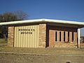
The Borden County Museum is located across from the post office, behind the county courthouse.
-
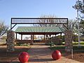
Entrance to Bicentennial Park, located across from the Borden County School
-
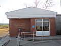
Post office
-
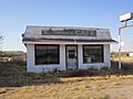
Caprock Cafe lies deserted across from the Borden County Courthouse.


Famous People from Gail
- Clinton D. "Casey" Vincent - He was a flying ace and one of the youngest generals in U.S. Air Force history.
Fun Facts About Gail
Gail, Texas, is officially known as a "Census Designated Place." This means it's a special area defined by the government for counting people. The town also has its own Zip Code, which is 79738.
See also
 para niños")
