
Big Spring, Texas facts for kids
Quick facts for kids
Big Spring, Texas
|
|
|---|---|
.jpg)
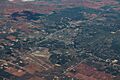
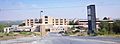
Aerial view of Big Spring
|
|
| Nickname(s):
"The Spring City"
|
|

Location of Big Spring in Howard County, Texas
|
|
| Country | United States |
| State | Texas |
| County | Howard |
| Founded | 1882 |
| Incorporated | 1907 |
| Government | |
| • Type | Council-Manager |
| Area | |
| • Total | 19.226 sq mi (49.795 km2) |
| • Land | 19.138 sq mi (49.566 km2) |
| • Water | 0.088 sq mi (0.229 km2) |
| Elevation | 2,441 ft (744 m) |
| Population
(2020)
|
|
| • Total | 26,144 |
| • Estimate
(2023)
|
22,373 |
| • Rank | TX: 140th |
| • Density | 1,169/sq mi (451.4/km2) |
| Time zone | UTC–6 (Central (CST)) |
| • Summer (DST) | UTC–5 (CDT) |
| ZIP Codes |
79720, 79721
|
| Area code(s) | 432 |
| FIPS code | 48-08236 |
| GNIS feature ID | 1330654 |
| Sales tax | 8.25% |

Big Spring is a city in Howard County, Texas, United States. It is the main city of the county. You can find it where U.S. Highway 87 and Interstate 20 meet. In 2020, about 26,144 people lived there.
The city gets its name from a single, large natural spring. This spring flowed into a small valley between Scenic Mountain and another hill. Even though some people might say "Big Springs," the official name is singular. The town was actually called "Big Springs" until around 1916.
Contents
Discovering Big Spring's Past


For a long time, the Big Spring area was a popular spot for Native American tribes. These included the Jumano, Apache, and Comanche. They used the spring as a place to get water.
In 1849, Captain Randolph B. Marcy led the first U.S. expedition to explore this area. He marked the spring as a good campsite on the Overland Trail to California. By the late 1870s, a small town grew there. It supported buffalo hunters. The first buildings were mostly simple hide huts and saloons.
How Ranching and Oil Shaped the City

Soon, Ranching became a big business in the area. Early ranchers included F.G. Oxsheer and C.C. Slaughter. A British rancher, Joseph Heneage Finch, bought a large amount of land in 1883. He built Big Spring's first permanent building, a butcher shop.
The arrival of the Texas and Pacific Railroad in the 1880s helped Big Spring grow. It became a busy railroading and ranching town.
A major change happened in the 1920s with the discovery of oil. This was the start of the oil industry in the Permian Basin of West Texas. Oil has been a very important part of the city's economy ever since. The oil industry was especially strong in Big Spring during the 1950s.
Big Spring's Military and Movie Connections
Another important part of Big Spring's history was Webb Air Force Base. It started as the Big Spring Bombardier School during World War II. After the war, it became a U.S. Air Force training base. It was named after James Webb, a local hero from World War II. The base closed in 1977, and its facilities were given to the city.
Big Spring has also been featured in movies! Parts of the 1969 film Midnight Cowboy were filmed here. This movie won an Academy Award for Best Picture. In 1980, the science-fiction movie Hangar 18 was also filmed in Big Spring.
In 1999, a very tall wind turbine was built in Big Spring. It was one of the largest in North America at that time. The city also hosted the FAI World Hang Gliding Championship in 2007.
The Story of the "Big Spring"
The "big spring" itself was very important to all life in the area. It is now dry, but water is pumped in to show how it used to look. In the 1840s, this spring was a disputed area between the Comanche and Pawnee tribes. It was a key watering hole for animals and early people.
Old reports describe the spring water as cold, clear, and always flowing. The spring pool was about 15 feet deep. The water would flow a short distance before going back underground.
The spring was a major stop on the Comanche War Trail. This trail was used by Native Americans traveling south from the Northern Plains. As settlers moved west, the spring became a vital stop on the Gold Rush Trail in the 1850s. It continued to be used as a main road for pioneers.
The spring got its water from an underground water source called an aquifer. This aquifer was located in limestone and sand layers. It held a lot of water because of many cracks and channels in the rocks.
By the late 1880s, the spring was producing over 100,000 gallons of water per day. However, the railroad and the growing town used too much water. The spring's water source dried up by the mid-1920s. Today, the city fills the spring with water from another source. This helps people imagine what it was like long ago.
Big Spring's Location and Weather
Big Spring is located in the middle of Howard County. It sits in the valley of Beals Creek, which flows east into the Colorado River. Interstate 20 runs through the north side of the city. You can use exits 174 to 182 to get there. I-20 goes east to Abilene and west to Midland.
U.S. Highway 87 used to go through the city center. Now, a bypass takes US 87 around the west side of Big Spring. The old route is now called Business US 87.
The city covers about 19.2 square miles. Most of this is land, with a small amount of water.
What is Big Spring's Climate Like?
| Climate data for Big Spring, Texas (1991–2020 normals, extremes 1948–2021) | |||||||||||||
|---|---|---|---|---|---|---|---|---|---|---|---|---|---|
| Month | Jan | Feb | Mar | Apr | May | Jun | Jul | Aug | Sep | Oct | Nov | Dec | Year |
| Record high °F (°C) | 85 (29) |
91 (33) |
97 (36) |
105 (41) |
109 (43) |
114 (46) |
110 (43) |
112 (44) |
108 (42) |
101 (38) |
92 (33) |
86 (30) |
114 (46) |
| Mean maximum °F (°C) | 78.0 (25.6) |
81.9 (27.7) |
88.5 (31.4) |
94.4 (34.7) |
100.7 (38.2) |
104.1 (40.1) |
103.5 (39.7) |
102.1 (38.9) |
97.8 (36.6) |
93.6 (34.2) |
83.5 (28.6) |
77.2 (25.1) |
106.4 (41.3) |
| Mean daily maximum °F (°C) | 58.0 (14.4) |
62.5 (16.9) |
71.0 (21.7) |
79.4 (26.3) |
87.0 (30.6) |
93.8 (34.3) |
95.8 (35.4) |
94.7 (34.8) |
87.9 (31.1) |
79.1 (26.2) |
67.1 (19.5) |
58.2 (14.6) |
77.9 (25.5) |
| Daily mean °F (°C) | 44.7 (7.1) |
48.6 (9.2) |
56.7 (13.7) |
64.7 (18.2) |
73.3 (22.9) |
81.0 (27.2) |
83.9 (28.8) |
83.1 (28.4) |
75.7 (24.3) |
66.1 (18.9) |
53.9 (12.2) |
45.5 (7.5) |
64.8 (18.2) |
| Mean daily minimum °F (°C) | 31.4 (−0.3) |
34.7 (1.5) |
42.4 (5.8) |
50.1 (10.1) |
59.5 (15.3) |
68.2 (20.1) |
72.1 (22.3) |
71.5 (21.9) |
63.6 (17.6) |
53.1 (11.7) |
40.7 (4.8) |
32.8 (0.4) |
51.7 (10.9) |
| Mean minimum °F (°C) | 19.0 (−7.2) |
21.5 (−5.8) |
27.3 (−2.6) |
36.2 (2.3) |
46.4 (8.0) |
59.0 (15.0) |
64.9 (18.3) |
64.0 (17.8) |
51.7 (10.9) |
36.8 (2.7) |
26.1 (−3.3) |
20.1 (−6.6) |
15.0 (−9.4) |
| Record low °F (°C) | −2 (−19) |
−5 (−21) |
9 (−13) |
25 (−4) |
31 (−1) |
43 (6) |
51 (11) |
50 (10) |
39 (4) |
19 (−7) |
15 (−9) |
1 (−17) |
−5 (−21) |
| Average precipitation inches (mm) | 0.73 (19) |
0.80 (20) |
1.15 (29) |
1.55 (39) |
2.54 (65) |
2.49 (63) |
1.58 (40) |
2.40 (61) |
2.39 (61) |
1.84 (47) |
1.35 (34) |
0.78 (20) |
19.60 (498) |
| Average snowfall inches (cm) | 0.3 (0.76) |
0.7 (1.8) |
0.0 (0.0) |
0.0 (0.0) |
0.0 (0.0) |
0.0 (0.0) |
0.0 (0.0) |
0.0 (0.0) |
0.0 (0.0) |
0.0 (0.0) |
0.3 (0.76) |
0.7 (1.8) |
2.0 (5.1) |
| Average precipitation days (≥ 0.01 in) | 2.8 | 3.3 | 3.5 | 2.8 | 4.1 | 5.3 | 4.0 | 5.2 | 5.0 | 4.1 | 2.6 | 2.8 | 45.5 |
| Average snowy days (≥ 0.1 in) | 0.2 | 0.2 | 0.0 | 0.0 | 0.0 | 0.0 | 0.0 | 0.0 | 0.0 | 0.0 | 0.1 | 0.3 | 0.8 |
| Source: NOAA | |||||||||||||
Big Spring has a hot, semi-arid climate. Summers are very hot, and winters are mild. The city gets about 19.6 inches of rain each year. Snowfall is very rare, with only about 2 inches per year.
Population and People of Big Spring
| Historical population | |||
|---|---|---|---|
| Census | Pop. | %± | |
| 1890 | 1,158 | — | |
| 1910 | 4,102 | — | |
| 1920 | 4,273 | 4.2% | |
| 1930 | 13,735 | 221.4% | |
| 1940 | 12,604 | −8.2% | |
| 1950 | 17,286 | 37.1% | |
| 1960 | 31,230 | 80.7% | |
| 1970 | 28,735 | −8.0% | |
| 1980 | 24,804 | −13.7% | |
| 1990 | 23,093 | −6.9% | |
| 2000 | 25,233 | 9.3% | |
| 2010 | 27,282 | 8.1% | |
| 2020 | 26,144 | −4.2% | |
| 2023 (est.) | 22,373 | −18.0% | |
| U.S. Decennial Census Texas Almanac: 1850–2000 2020 Census |
|||
In 2020, Big Spring had 26,144 residents. About 21.3% of the people were under 18 years old. Around 11.3% were 65 or older.
The city is home to a diverse population. In 2020, about 64.6% of residents were White. Around 6.1% were African American. About 53.0% of the population identified as Hispanic or Latino.
Fun Things to Do in Big Spring

Big Spring is known for hosting major hang-gliding championships. It was also a filming location for movies like Midnight Cowboy.
Places to Visit and Explore
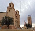
- Settles Hotel: A historic hotel that has been beautifully restored.
- Big Spring Municipal Auditorium: A large venue for concerts and shows. It's home to the Big Spring Symphony.
- Heritage Museum of Big Spring: Learn about local history and interesting facts.
- Hangar 25 Air Museum: See a restored World War II hangar. It teaches about the Big Spring Army Air Force Bombardier School and Webb Air Force Base.
- Big Spring State Park: Enjoy nature and outdoor activities. The picnic pavilion was built in the 1930s.
- Comanche Trail Park: A huge city park with the historic "big spring." It has an amphitheater, golf course, and trails.
- Moss Creek Lake: A great spot for recreation. You can swim, play paintball, or ride dirt bikes.
- Signal Peak: Also called Signal Mountain, this landmark was used by Native Americans. It's about 10 miles southeast of the city.
Learning and Education
Big Spring offers several educational opportunities:
- Big Spring Independent School District: Provides public education for students.
- Howard College: A local college for higher education.
- Southwest Collegiate Institute for the Deaf: A special college for deaf students.
Important Roads and Services

Major Roads
 Interstate 20
 U.S. Highway 87
 State Highway 176
 State Highway 350
Community Services
The Texas Department of State Health Services runs a psychiatric hospital in Big Spring. It opened in 1939 and is a major employer. The United States Postal Service also has an office in the city.
The Federal Bureau of Prisons (BOP) operates the Federal Correctional Institution, Big Spring. There is also a privately run correctional center nearby.
The Colorado River Municipal Water District has a special water treatment plant here. It cleans water for Big Spring and other nearby cities.
Famous People from Big Spring
Many notable people have connections to Big Spring:
- Betty Buckley: A famous actress and singer who won a Tony Award.
- Carl Bunch: A drummer who played for Buddy Holly and Roy Orbison.
- Bubba Franks: A former NFL tight end for the Green Bay Packers. He grew up and played high school football in Big Spring.
- Lefty Frizzell: A well-known country music singer-songwriter.
- Charley Johnson: An NFL quarterback for the St. Louis Cardinals and Denver Broncos.
- Ryan Tannehill: A quarterback for the Tennessee Titans.
Images for kids
-
Aerial view of Big Spring
-

Location of Big Spring in Howard County, Texas
-
The Municipal Auditorium in Big Spring
-
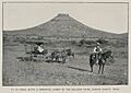
Signal Peak located 10 miles to the southeast of Big Spring (Robert T. Hill, 1889)
-

Big Spring decorative sign
-
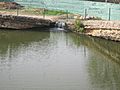
The "big spring" in Comanche Trail Park
-
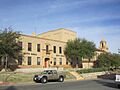
Big Spring City Hall
-
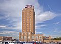
Newly refurbished Settles Hotel
-
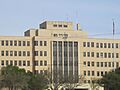
Big Spring Veterans Hospital
-
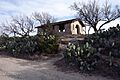
The picnic pavilion at Big Spring State Park was built by the Civilian Conservation Corps in the 1930s.
-
Scenic Mountain Medical Center serves the community.


See also
 In Spanish: Big Spring para niños
