Galindo y Perahuy facts for kids
Quick facts for kids
Galindo y Perahuy
|
|
|---|---|

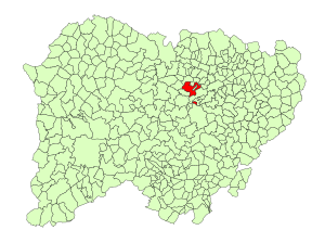
Location in Salamanca
|
|
| Country | Spain |
| Autonomous community | Castile and León |
| Province | Salamanca |
| Comarca | Campo de Salamanca |
| Area | |
| • Total | 44 km2 (17 sq mi) |
| Elevation | 797 m (2,615 ft) |
| Population
(2018)
|
|
| • Total | 690 |
| • Density | 15.68/km2 (40.6/sq mi) |
| Time zone | UTC+1 (CET) |
| • Summer (DST) | UTC+2 (CEST) |
| Postal code |
37449
|
Galindo y Perahuy is a small village and a municipality located in the western part of Spain. It is found in the province of Salamanca, which is part of the Castile and León region.
This charming village is about 22 kilometers (about 14 miles) away from Salamanca, the main city of the province. In 2018, around 690 people lived in Galindo y Perahuy.
Contents
Galindo y Perahuy: A Spanish Village
Galindo y Perahuy is a quiet place in the Salamanca province. It's known for its peaceful rural setting. The village is a great example of a traditional Spanish community.
What is the Geography of Galindo y Perahuy?
The area of Galindo y Perahuy covers about 44 square kilometers (around 17 square miles). This means it's a fairly small municipality. The village sits 797 meters (about 2,615 feet) above sea level. This elevation gives it a slightly cooler climate than lower areas. The postal code for Galindo y Perahuy is 37449.
How Do People Travel to Galindo y Perahuy?
Getting to Galindo y Perahuy is easy thanks to the A-62 highway. This important road connects the village to the city of Salamanca and even goes all the way to Portugal. This makes it simple for people to visit or for residents to travel for work or fun.
Recently, more people have started moving to the area around Galindo y Perahuy. This is because new homes are being built nearby, like in a development called "La RAD." However, many of these new residents still mostly connect with Salamanca for their daily lives, rather than the village itself.
Images for kids
See also
 In Spanish: Galindo y Perahuy para niños
 | Victor J. Glover |
 | Yvonne Cagle |
 | Jeanette Epps |
 | Bernard A. Harris Jr. |


