
Gambrill State Park facts for kids
Quick facts for kids Gambrill State Park |
|
|---|---|
 |
|

Gambrill State Park
Location in Maryland
|
|
| Location | Frederick County, Maryland, United States |
| Nearest city | Frederick, Maryland |
| Area | 1,207 acres (4.88 km2) |
| Elevation | 1,549 ft (472 m) |
| Designation | Maryland state park |
| Established | 1934 |
| Administrator | Maryland Department of Natural Resources |
| Website | Gambrill State Park |
Gambrill State Park is a fun place for outdoor activities located on Catoctin Mountain in Frederick County, Maryland. It's close to the city of Frederick. This state park is famous for its amazing views of the area. You can see these views from special stone overlooks. These overlooks were built in the 1930s by a group called the Civilian Conservation Corps. The park is managed by the Maryland Department of Natural Resources.
Contents
Where is Gambrill State Park?
Gambrill State Park is about 51 miles (82 km) northwest of Washington, D.C.. It's also about 53 miles (85 km) west of Baltimore. The park sits on Catoctin Mountain. To get there, you can take Gambrill Park Road. This road is about six miles (10 km) from Frederick on Route 40 West. The park road goes over Catoctin Mountain. It leads to the campground, hiking trails, and the High Knob areas of the park.
History of the Park
The park is named after James H. Gambrill, Jr. (1866-1951). He was a businessman in the grain industry and involved in Frederick city politics. Mr. Gambrill loved nature and visited Catoctin Mountain often. He wanted to create a park there. He convinced other local business people to buy the land. They then gave this land to the city of Frederick.
One year later, the city gave the land to the state of Maryland. Gambrill State Park officially opened on September 7, 1934. Many of the park's buildings and structures were built in the 1930s. This includes the roads, stone overlooks, picnic shelters, the Tea Room, and the ranger’s home. These were all built by the Civilian Conservation Corps. This group helped people find work during the Great Depression.
Things to Do at the Park
Gambrill State Park offers many activities. You can find trails for hiking and mountain biking. There's also a picnic area with a playground. Plus, there's a small pond where you can go fishing.
Explore the Trails
The park has several trails, each marked with its own color. Different volunteer groups help take care of these trails. Here are some of the trails you can explore:
- White Oak Trail: This trail is marked with white blazes. It's about 1 mile (1.6 km) long. Only hikers are allowed on this trail.
- Red Maple Trail: This trail has red blazes and is about 1 mile (1.6 km) long. It connects the campground to the rest of the park. Be aware, it has one short, steep part.
- Green Ash Trail: Marked with green blazes, this trail is about 2 miles (3.2 km) long. It has several steep slopes and not much flat ground.
- Black Locust Trail: This trail has black blazes on a white background. It's about 3.3 miles (5.3 km) long. You'll find a mix of steep slopes and flat areas. It goes through wooded areas and offers views of Frederick Valley to the east. You can also see Middletown Valley to the west.
- Yellow Poplar Trail: This is the longest trail in Gambrill, about 7.1 miles (11.4 km) long. It passes by the stone overlooks built by the CCC as it goes up the mountain.
- Catoctin Trail: This long trail is marked with blue blazes. About 3.0 miles (4.8 km) of it goes through Gambrill State Park. The trail continues north through other parks and natural areas.
Amazing Overlooks

At the top of High Knob, which is about 1,600 feet (490 m) high, there are three stone overlooks. These overlooks offer fantastic views of the area.
- To the North: You can see the rugged, tree-covered mountains of the Frederick City Municipal Forest.
- To the South: You'll see Crampton's Gap. This is a historic spot from the American Civil War. Gathland State Park is also located there. You can also see the Middletown and Monocacy valleys.
- To the West: You can view South Mountain. This was the site of many Civil War battles.
Images for kids
-
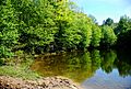
View of a creek in the park.
