Arkaroola facts for kids
Quick facts for kids ArkaroolaSouth Australia |
|||||||||
|---|---|---|---|---|---|---|---|---|---|
| Location | 700 km (435 mi) from Adelaide city centre | ||||||||
| State electorate(s) | Stuart | ||||||||
| Federal Division(s) | Grey | ||||||||
 |
|||||||||
|
|||||||||
Arkaroola is a special place in South Australia. It's known as the Arkaroola Wilderness Sanctuary. This huge area covers about 610 square kilometers. It is a mix of privately owned land and land leased from the government. Arkaroola is about 700 kilometers north of Adelaide city centre. It sits in the Northern Flinders Ranges, next to a national park. Most people drive there, but you can also fly in from Adelaide airports. The movie The Tracker was filmed here in 2002.
Contents
Discovering Arkaroola's Past
The first people to live in this area were the Adnyamathanha people. They have a special story about how Arkaroola was made. They say a giant mythical monster named Arkaroo drank Lake Frome dry. Then, he crawled into the mountains. When he urinated, he created the waterholes you see today. His movements also formed Arkaroola Creek.
Early European Visits and Mining
The first European explorers came to Arkaroola in the 1800s. Edward John Eyre visited in 1840. George Goyder surveyed the land in 1857. A small copper mine started nearby in 1860. But a big drought in 1863 made the miners leave. People returned in 1903 when rubies and sapphires were found. Later, uranium was discovered by Douglas Mawson, a famous explorer.
Protecting the Land
The land was always tough for farming. Many projects failed quickly. People kept looking for uranium, which helped build good roads. By 1935, the Arkaroola property was fenced. They also started removing animals like donkeys and camels that were not native.
The Arkaroola Wilderness Sanctuary was created in 1968. A geologist named Reg Sprigg bought the land. He had studied the area before. He turned the 610 square kilometer property into a wildlife sanctuary.
Arkaroola's Future: No Mining!
In 2011, the government of South Australia made a big announcement. They banned mining in Arkaroola forever! This was to protect the area. They also want Arkaroola to be listed as a National Heritage site. They are even trying to get it listed as a World Heritage site. Arkaroola was officially added to the South Australian Heritage Register in 2012.
Protecting Arkaroola from Mining
For a while, Arkaroola was at risk from uranium mining. A company was exploring near Mount Gee. In 2008, this company was caught illegally dumping radioactive materials. They were told to stop drilling.
Later, the government allowed them to drill again. This made many people upset. A survey showed that most South Australians did not want mining in Arkaroola. Because of this public pressure, the government banned mining in July 2011. This ban protects Arkaroola, including Mount Gee. The Arkaroola Protection Act 2012 makes sure no mining happens there.
Amazing Birds of Arkaroola
Arkaroola is part of a large area called the Gammon Ranges and Arkaroola Important Bird Area. This area is important for birds. It's home to a special bird called the short-tailed grasswren. You can also find pied honeyeaters, chirruping wedgebills, and cinnamon quail-thrushes here.
Fun Things to Do in Arkaroola
Arkaroola offers many exciting activities for visitors. You can explore the area by car or on foot.
Driving Adventures: Road Loops and 4WD Tracks
There are tracks for both regular cars and 4-wheel drives. Some are easy, and some are more challenging.
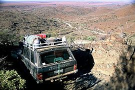
The Echo Camp Backtrack is a great self-drive track. It takes you through beautiful country. You'll go over hills and onto the plains. This track connects back to Arkaroola Village. You'll pass places like Claude's Pass and Stubb's Waterhole. You might even see yellow-footed rock wallabies at Bararranna Gorge.
You can also take guided tours. The Ridge Top Tour goes to Siller's Lookout. From there, you can see across the plains to Lake Frome. Siller's Lookout is named after Bill Siller. His companies built the track and found the nearby Beverley Uranium Mine.
Exploring on Foot: Bushwalking Trails
Arkaroola has many walking trails. Some are guided, and some you can explore on your own. Here are a few popular ones:
- Spriggina Trail (1 to 1.5 hours)
- Bararranna Gorge Walk (6.8 km – 3.5 hours)
- Acacia Ridge (4 to 5 hours)
- Surveyor's Cairn (40 minutes)
- Griselda Hill (1.5 hours)
- Mawson Valley Trail (2.5 to 3 hours)
- Arkaroola Waterhole (4 hours)
- Oppaminda Trail (length varies)
You can find maps and information about these trails.
Stargazing: Astronomy at Night
Arkaroola is a fantastic place to look at the stars. It has two large 14-inch telescopes. The skies are usually clear because it's so far from city lights. This makes it perfect for seeing the night sky.
Unique Springs: Paralana Radioactive Springs
The Paralana geothermal springs are north of Arkaroola. Hot water bubbles out of the ground here. This happens because rocks deep underground have uranium. The uranium gives off heat. Water seeps through cracks in the rocks and gets hot. It then comes out as hot springs.
These springs also have a special gas called radon. Because of this gas, it's best not to stay too close for a long time. A unique type of algae lives in these warm springs. It can survive the hot temperatures and special conditions.
Climbing The Pinnacle
The Pinnacle is a mountain in the area. It was formed by a volcano. This spot is popular for rock climbing.
The Arkaroola Village
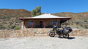
The Arkaroola Village is where visitors can stay. You can find motel rooms, caravan sites, and camping spots.
The village has a restaurant and a bar. There's also a swimming pool to cool off. You'll find a small shop for supplies. There's a service station for petrol and diesel. A vehicle workshop is also available if you need car repairs.
Arkaroola's Climate
Arkaroola has a dry climate. Summers are very hot, sometimes with storms. Winters are cold and dry. Arkaroola holds a record for the highest overnight low temperature in Australia. On January 24, 1982, the temperature only dropped to 35.5 degrees Celsius!
| Climate data for Arkaroola | |||||||||||||
|---|---|---|---|---|---|---|---|---|---|---|---|---|---|
| Month | Jan | Feb | Mar | Apr | May | Jun | Jul | Aug | Sep | Oct | Nov | Dec | Year |
| Record high °C (°F) | 45.3 (113.5) |
44.5 (112.1) |
41.2 (106.2) |
37.9 (100.2) |
30.0 (86.0) |
27.7 (81.9) |
26.2 (79.2) |
31.8 (89.2) |
37.5 (99.5) |
40.1 (104.2) |
44.4 (111.9) |
45.5 (113.9) |
45.5 (113.9) |
| Mean daily maximum °C (°F) | 34.3 (93.7) |
33.2 (91.8) |
29.8 (85.6) |
25.2 (77.4) |
20.2 (68.4) |
16.8 (62.2) |
16.5 (61.7) |
19.0 (66.2) |
23.3 (73.9) |
26.6 (79.9) |
30.1 (86.2) |
32.6 (90.7) |
25.6 (78.1) |
| Mean daily minimum °C (°F) | 20.1 (68.2) |
19.3 (66.7) |
15.8 (60.4) |
11.1 (52.0) |
7.1 (44.8) |
4.4 (39.9) |
3.3 (37.9) |
4.6 (40.3) |
8.1 (46.6) |
11.6 (52.9) |
15.5 (59.9) |
17.7 (63.9) |
11.5 (52.7) |
| Record low °C (°F) | 10.4 (50.7) |
9.4 (48.9) |
5.7 (42.3) |
1.0 (33.8) |
−2.0 (28.4) |
−3.7 (25.3) |
−6.0 (21.2) |
−4.3 (24.3) |
−1.6 (29.1) |
1.0 (33.8) |
6.6 (43.9) |
7.3 (45.1) |
−6.0 (21.2) |
| Average rainfall mm (inches) | 32.9 (1.30) |
39.5 (1.56) |
31.2 (1.23) |
14.3 (0.56) |
17.2 (0.68) |
15.0 (0.59) |
15.1 (0.59) |
14.0 (0.55) |
15.1 (0.59) |
19.2 (0.76) |
17.6 (0.69) |
24.9 (0.98) |
256 (10.08) |
| Average rainy days (≥ 0.2mm) | 3.0 | 2.9 | 2.3 | 2.3 | 2.9 | 3.1 | 3.5 | 3.2 | 2.9 | 3.2 | 3.0 | 3.0 | 35.3 |
| Source: Bureau of Meteorology | |||||||||||||


