Gardnerville Ranchos, Nevada facts for kids
Quick facts for kids
Gardnerville Ranchos, Nevada
|
|
|---|---|

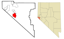
Location of Gardnerville Ranchos, Nevada
|
|
| Country | United States |
| State | Nevada |
| Area | |
| • Total | 10.32 sq mi (26.74 km2) |
| • Land | 10.32 sq mi (26.74 km2) |
| • Water | 0.00 sq mi (0.00 km2) |
| Elevation | 4,859 ft (1,481 m) |
| Population
(2020)
|
|
| • Total | 11,318 |
| • Density | 1,096.17/sq mi (423.24/km2) |
| Time zone | UTC−8 (Pacific (PST)) |
| • Summer (DST) | UTC−7 (PDT) |
| FIPS code | 32-26500 |
| GNIS feature ID | 1867346 |
Gardnerville Ranchos is a special kind of community in Douglas County, Nevada, United States. It's called a census-designated place, which means it's an area that the government counts for population, but it's not officially a city or town. As of 2020, about 11,318 people live here. This area is also part of a larger region called the Gardnerville Ranchos Micropolitan Statistical Area.
Contents
Exploring Gardnerville Ranchos: Location and Size
Gardnerville Ranchos is located in Nevada. The United States Census Bureau says that this area covers about 10.32 square miles (26.74 square kilometers) of land. There is no water area within its borders.
Weather and Climate in Gardnerville Ranchos
Gardnerville Ranchos has a type of weather called a warm-summer Mediterranean climate. This means it usually has warm, dry summers and mild, wet winters. It's similar to the weather you might find in places around the Mediterranean Sea.
| Climate data for Gardnerville Ranchos, 1991–2020 simulated normals (4843 ft elevation) | |||||||||||||
|---|---|---|---|---|---|---|---|---|---|---|---|---|---|
| Month | Jan | Feb | Mar | Apr | May | Jun | Jul | Aug | Sep | Oct | Nov | Dec | Year |
| Mean daily maximum °F (°C) | 47.5 (8.6) |
51.1 (10.6) |
57.6 (14.2) |
62.4 (16.9) |
71.1 (21.7) |
81.3 (27.4) |
90.1 (32.3) |
89.4 (31.9) |
82.4 (28.0) |
70.9 (21.6) |
57.0 (13.9) |
46.6 (8.1) |
67.3 (19.6) |
| Daily mean °F (°C) | 34.0 (1.1) |
37.0 (2.8) |
42.3 (5.7) |
46.6 (8.1) |
54.3 (12.4) |
62.4 (16.9) |
69.8 (21.0) |
68.5 (20.3) |
61.7 (16.5) |
51.4 (10.8) |
40.6 (4.8) |
33.3 (0.7) |
50.2 (10.1) |
| Mean daily minimum °F (°C) | 20.3 (−6.5) |
23.0 (−5.0) |
27.1 (−2.7) |
30.7 (−0.7) |
37.4 (3.0) |
43.5 (6.4) |
49.5 (9.7) |
47.8 (8.8) |
41.0 (5.0) |
32.0 (0.0) |
24.3 (−4.3) |
19.9 (−6.7) |
33.0 (0.6) |
| Average precipitation inches (mm) | 1.96 (49.66) |
1.67 (42.46) |
1.38 (35.05) |
0.66 (16.83) |
0.64 (16.32) |
0.36 (9.22) |
0.24 (5.97) |
0.27 (6.76) |
0.24 (6.11) |
0.69 (17.43) |
1.01 (25.78) |
1.90 (48.36) |
11.02 (279.95) |
| Average dew point °F (°C) | 20.8 (−6.2) |
21.4 (−5.9) |
22.6 (−5.2) |
24.6 (−4.1) |
30.4 (−0.9) |
33.8 (1.0) |
38.5 (3.6) |
36.1 (2.3) |
31.1 (−0.5) |
25.9 (−3.4) |
21.9 (−5.6) |
19.9 (−6.7) |
27.2 (−2.6) |
| Source: PRISM Climate Group | |||||||||||||
Who Lives in Gardnerville Ranchos?
The number of people living in Gardnerville Ranchos has grown over the years. Here's a quick look at how the population has changed:
| Historical population | |||
|---|---|---|---|
| Census | Pop. | %± | |
| 1980 | 3,542 | — | |
| 1990 | 7,455 | 110.5% | |
| 2000 | 11,054 | 48.3% | |
| 2010 | 11,312 | 2.3% | |
| 2020 | 11,318 | 0.1% | |
| U.S. Decennial Census | |||
In 2000, there were 11,054 people living in Gardnerville Ranchos. About 4,003 homes were counted. Many different kinds of people live here. About 29.6% of the population was under 18 years old. The average age of people living here was 37 years.
Getting Around Gardnerville Ranchos
For transportation, people in Gardnerville Ranchos can use the Douglas Area Rural Transit. This service helps residents travel around the area.
See also
 In Spanish: Gardnerville Ranchos para niños
 | Tommie Smith |
 | Simone Manuel |
 | Shani Davis |
 | Simone Biles |
 | Alice Coachman |

