Garfield Plantation, Maine facts for kids
Quick facts for kids
Garfield Plantation, Maine
|
|
|---|---|
|
Plantation
|
|

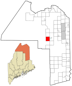
Location of Garfield Plantation, Maine
|
|
| Country | United States |
| State | Maine |
| County | Aroostook |
| Area | |
| • Total | 38.6 sq mi (99.9 km2) |
| • Land | 38.3 sq mi (99.2 km2) |
| • Water | 0.27 sq mi (0.7 km2) |
| Elevation | 610 ft (186 m) |
| Population
(2020)
|
|
| • Total | 79 |
| • Density | 2.047/sq mi (0.791/km2) |
| Time zone | UTC-5 (Eastern (EST)) |
| • Summer (DST) | UTC-4 (EDT) |
| ZIP code |
04732
|
| Area code(s) | 207 |
| FIPS code | 23-27120 |
| GNIS feature ID | 0582487 |
Garfield Plantation is a small community in Aroostook County, Maine, in the United States. It is called a "plantation" because of a special type of local government used in Maine. In 2020, about 79 people lived there.
Contents
A Name with History
Garfield Plantation got its name from James A. Garfield. He was the 20th President of the United States. He served as president in 1881.
Where is Garfield Plantation?
This plantation is located in the beautiful state of Maine. The total area of Garfield Plantation is about 38.6 square miles (99.9 km2). Most of this area, 38.3 square miles (99.2 km2), is land. Only a small part, 0.27 square miles (0.7 km2), is water.
Who Lives Here?
| Historical population | |||
|---|---|---|---|
| Census | Pop. | %± | |
| 1880 | 80 | — | |
| 1890 | 86 | 7.5% | |
| 1900 | 111 | 29.1% | |
| 1910 | 121 | 9.0% | |
| 1920 | 142 | 17.4% | |
| 1930 | 91 | −35.9% | |
| 1940 | 97 | 6.6% | |
| 1950 | 116 | 19.6% | |
| 1960 | 89 | −23.3% | |
| 1970 | 104 | 16.9% | |
| 1980 | 107 | 2.9% | |
| 1990 | 102 | −4.7% | |
| 2000 | 86 | −15.7% | |
| 2010 | 81 | −5.8% | |
| 2020 | 79 | −2.5% | |
| U.S. Decennial Census | |||
In 2000, there were 86 people living in Garfield Plantation. These people lived in 37 different homes, called households. About 24 of these households were families.
The population density was very low. This means there were only about 2.3 people for every square mile. All the people living there were White.
Households and Families
Out of the 37 households, about 27% had children under 18 living with them. Almost half, 48.6%, were married couples living together. Some households, 8.1%, had a female head with no husband present. About 35.1% were not families.
About 27% of households had only one person living there. And 18.9% of households had one person who was 65 or older. The average number of people in a household was 2.32. For families, the average was 2.67 people.
Age and Income
The ages of people in Garfield Plantation varied. About 17.4% were under 18 years old. About 10.5% were between 18 and 24. People aged 25 to 44 made up 23.3% of the population. Those aged 45 to 64 were 27.9%. And 20.9% were 65 or older. The average age was 44 years.
The median income for a household was $31,250 per year. For families, the median income was $33,750. The average income per person was $15,455. About 19.2% of all people lived below the poverty line. This included 47.1% of those under 18 and 5.9% of those over 64.
See also
 In Spanish: Garfield Plantation para niños
 | Victor J. Glover |
 | Yvonne Cagle |
 | Jeanette Epps |
 | Bernard A. Harris Jr. |

