
Garrapata State Park facts for kids
Quick facts for kids Garrapata State Park |
|
|---|---|
|
IUCN Category III (Natural Monument)
|
|

The granite coast of Garrapata State Park
|
|

Garrapata State Park
Location in California

Garrapata State Park
Location in the United States
|
|
| Location | Monterey County, California, USA |
| Nearest city | Carmel, California |
| Area | 2,939 acres (1,189 ha) |
| Established | 1979 |
| Governing body | California Department of Parks and Recreation |
Garrapata State Park is a beautiful state park in California, USA. It's located along the famous California State Route 1, about 6.7 miles (10.8 km) south of Carmel and 18 miles (29 km) north of Big Sur Village on the Monterey coast. This park covers a large area of 2,939 acres (1,189 ha) and was created in 1979. You can often spot amazing marine animals here, like California sea lions, harbor seals, and sea otters. If you visit during their migration season, you might even see gray whales swimming close to the coast!
Contents
Exploring Garrapata State Park
Garrapata State Park offers two miles (3.2 km) of stunning beachfront. It's a great place for coastal hiking, with trails that lead to amazing views of the Pacific Ocean. You can even climb about 50 feet (15 m) for a better view! The park has many different types of plants. You'll find trails that go from the sandy ocean beaches into thick coast redwood forests.
Coastal Plants and Wildlife
The areas along the coast, both west and east of the Big Sur Coast Highway, are covered with various coastal plants. These include coyote bush, California coffeeberry, California sagebrush, bush lupine, and blue blossom. The park also has special coastal headlands at a spot called Soberanes Point. As mentioned, the waters here are home to California sea lions, harbor seals, and sea otters. Gray whales also swim past the park during their long yearly journey.
Parking and Access
There isn't one main entrance to Garrapata State Park. Instead, visitors can park in several pullouts along the Big Sur Coast Highway. These parking spots start about 5.4 miles (8.7 km) south of Rio Road in Carmel and stretch along the coast for about 2.1 miles (3.4 km). The park is marked by just one sign on the west side of the road. Each parking area has a numbered turnout to help you find your way.
Famous Photography Spot
A famous photographer named Edward Weston lived nearby in Carmel. He took many of his best-known pictures in or very close to what is now Garrapata State Park.
History of Garrapata State Park
The land where Garrapata State Park now stands was once home to Native American tribes. These included the Ohlone and Rumsien tribes.
Early Land Ownership
In 1835, a part of the park's land was given to Teodoro Gonzalez by the governor of Alta California, Juan Bautista Alvarado. This area was called Rancho San Jose y Sur Chiquito. It was later given to Marcelino Escobar. This land stretched along the coast and was used for ranching.
William B. Post bought some land here in the mid-1800s and lived on it for a few years. Later, in 1867, he sold his land to David Castro. The next year, David Castro sold it to Ezequiel Soberanes.
The Soberanes Family Ranch
Ezequiel Soberanes ran a successful cattle and sheep ranch for 24 years. The Soberanes family was well-known in the area for their musical talents. They also welcomed other ranchers who were traveling along the coast to Monterey.
The Doud Ranch
In 1891, Francis Doud, an early resident of Monterey, bought the Soberanes land and other pieces of property. He created the Doud Ranch, which continued to raise cattle until the early 1950s. The Doud family's original ranch house was made of wood and unfortunately burned down in the 1960s.
Park Establishment
The state of California bought the first part of this property in 1980. Garrapata, which means "tick" in Spanish, was officially named a state park in 1985. Some places within the park still have names that honor these early families.
The Soberanes Fire of 2016
Most of Garrapata State Park was affected by the 2016 Soberanes Fire. This large fire started in the park because of an illegal campfire. The fire burned for more than two months. It was a very expensive fire for the United States at the time. The person who started the campfire was never found. As of May 2018, all the trails on the west side of Highway 1 are open for hikers. However, only a small part of one trail on the east side of Highway 1 is open.
Gallery
-
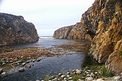
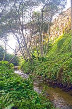
Garrapata Creek outlet
-
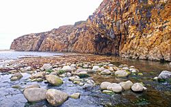
Cove at the mouth of Garrapata Creek
-
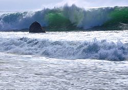
Garrapata coast is characterized by its big waves.
-
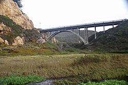
Bridge over Garrapata Creek
-
Garrapata Creek


