
Garrison, North Dakota facts for kids
Quick facts for kids
Garrison, North Dakota
|
|
|---|---|

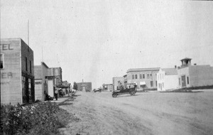
Garrison in 2009
|
|

Location of Garrison, North Dakota
|
|
| Country | United States |
| State | North Dakota |
| County | McLean |
| Founded | 1905 |
| Area | |
| • Total | 1.40 sq mi (3.62 km2) |
| • Land | 1.40 sq mi (3.62 km2) |
| • Water | 0.00 sq mi (0.00 km2) |
| Elevation | 1,923 ft (586 m) |
| Population
(2020)
|
|
| • Total | 1,462 |
| • Estimate
(2022)
|
1,467 |
| • Density | 1,045.03/sq mi (403.63/km2) |
| Time zone | UTC-6 (Central (CST)) |
| • Summer (DST) | UTC-5 (CDT) |
| ZIP code |
58540
|
| Area code(s) | 701 |
| FIPS code | 38-29460 |
| GNIS feature ID | 1036052 |
| Highways | ND 37 |
Garrison is a small city located in McLean County, North Dakota, in the United States. In 2020, about 1,462 people lived there. It's a friendly place with a rich history.
Contents
History of Garrison
Garrison was officially started in 1905. This happened when the Soo Line Railroad built its tracks to this area. The town got its name from a nearby stream called Garrison Creek. A post office has been open in Garrison since 1903, helping people send and receive mail for a long time.
Geography and Climate
Garrison covers a total area of about 1.38 square miles (3.62 square kilometers). All of this area is land, meaning there are no large lakes or rivers within the city limits.
Weather in Garrison
The weather in Garrison changes a lot throughout the year. Summers are generally warm, while winters can be very cold and snowy.
| Climate data for Garrison, North Dakota (1991–2020 normals, extremes 1948–present) | |||||||||||||
|---|---|---|---|---|---|---|---|---|---|---|---|---|---|
| Month | Jan | Feb | Mar | Apr | May | Jun | Jul | Aug | Sep | Oct | Nov | Dec | Year |
| Record high °F (°C) | 54 (12) |
63 (17) |
78 (26) |
93 (34) |
96 (36) |
102 (39) |
105 (41) |
108 (42) |
104 (40) |
95 (35) |
75 (24) |
61 (16) |
108 (42) |
| Mean daily maximum °F (°C) | 19.5 (−6.9) |
24.3 (−4.3) |
36.7 (2.6) |
52.8 (11.6) |
65.8 (18.8) |
74.5 (23.6) |
81.3 (27.4) |
81.2 (27.3) |
71.3 (21.8) |
55.0 (12.8) |
37.9 (3.3) |
25.0 (−3.9) |
52.1 (11.2) |
| Daily mean °F (°C) | 10.6 (−11.9) |
14.7 (−9.6) |
27.0 (−2.8) |
41.3 (5.2) |
54.1 (12.3) |
63.8 (17.7) |
69.8 (21.0) |
68.5 (20.3) |
58.9 (14.9) |
44.1 (6.7) |
28.9 (−1.7) |
16.7 (−8.5) |
41.5 (5.3) |
| Mean daily minimum °F (°C) | 1.6 (−16.9) |
5.1 (−14.9) |
17.2 (−8.2) |
29.7 (−1.3) |
42.4 (5.8) |
53.1 (11.7) |
58.3 (14.6) |
55.9 (13.3) |
46.4 (8.0) |
33.1 (0.6) |
19.9 (−6.7) |
8.5 (−13.1) |
30.9 (−0.6) |
| Record low °F (°C) | −48 (−44) |
−37 (−38) |
−31 (−35) |
−12 (−24) |
12 (−11) |
28 (−2) |
35 (2) |
29 (−2) |
17 (−8) |
−3 (−19) |
−27 (−33) |
−42 (−41) |
−48 (−44) |
| Average precipitation inches (mm) | 0.43 (11) |
0.36 (9.1) |
0.67 (17) |
1.23 (31) |
2.82 (72) |
3.78 (96) |
2.73 (69) |
2.11 (54) |
1.68 (43) |
1.29 (33) |
0.63 (16) |
0.45 (11) |
18.18 (462) |
| Average snowfall inches (cm) | 6.8 (17) |
6.2 (16) |
7.4 (19) |
2.9 (7.4) |
1.3 (3.3) |
0.0 (0.0) |
0.0 (0.0) |
0.0 (0.0) |
0.0 (0.0) |
2.5 (6.4) |
5.7 (14) |
9.9 (25) |
42.7 (108) |
| Average precipitation days (≥ 0.01 in) | 4.4 | 4.0 | 5.3 | 7.1 | 9.8 | 10.9 | 8.7 | 7.3 | 6.7 | 6.2 | 4.6 | 4.6 | 79.6 |
| Average snowy days (≥ 0.1 in) | 4.2 | 3.9 | 3.1 | 1.3 | 0.4 | 0.0 | 0.0 | 0.0 | 0.0 | 1.0 | 2.8 | 4.6 | 21.3 |
| Source: NOAA | |||||||||||||
Population and People
| Historical population | |||
|---|---|---|---|
| Census | Pop. | %± | |
| 1910 | 406 | — | |
| 1920 | 714 | 75.9% | |
| 1930 | 1,024 | 43.4% | |
| 1940 | 1,117 | 9.1% | |
| 1950 | 1,890 | 69.2% | |
| 1960 | 1,794 | −5.1% | |
| 1970 | 1,614 | −10.0% | |
| 1980 | 1,830 | 13.4% | |
| 1990 | 1,530 | −16.4% | |
| 2000 | 1,318 | −13.9% | |
| 2010 | 1,453 | 10.2% | |
| 2020 | 1,462 | 0.6% | |
| 2022 (est.) | 1,467 | 1.0% | |
| U.S. Decennial Census 2020 Census |
|||
Garrison's Population in 2010
In 2010, the city of Garrison had 1,453 people living there. There were 654 households, which are groups of people living together in one home. About 378 of these were families.
Most people in Garrison were White (93.3%). About 4.5% were Native American, and 2.0% were from two or more races. About 2.1% of the population identified as Hispanic or Latino.
In terms of age, the average age in Garrison was 51.3 years old. About 18.6% of the people were under 18 years old. Many residents, about 30.8%, were 65 years or older. This means Garrison has a good number of older, experienced residents.
Garrison Municipal Airport
Garrison has its own public airport, called Garrison Municipal Airport (FAA LID: D05). It is located just one mile (1.6 km) west of the city's main business area. The airport has two runways for planes to land and take off. One runway is made of asphalt, and the other is a grass surface.
Education in Garrison
Students in Garrison attend schools that are part of the Garrison Public School District 51. This district provides education for children living in the city and surrounding areas.
Fun Places to Visit
Garrison and its nearby areas offer several interesting places to visit:
- Fort Stevenson State Park
- Fort Stevenson State Park Arboretum
- Garrison Golf Course
See also
 In Spanish: Garrison (Dakota del Norte) para niños
