Gawler Belt, South Australia facts for kids
Quick facts for kids Gawler BeltSouth Australia |
|||||||||||||||
|---|---|---|---|---|---|---|---|---|---|---|---|---|---|---|---|

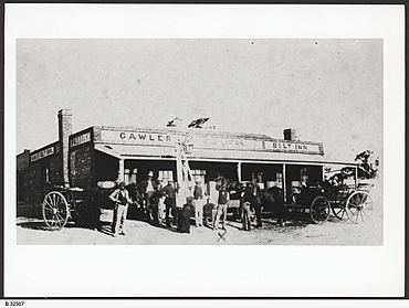
Gawler Belt Inn in 1880
|
|||||||||||||||
| Postcode(s) | 5118 | ||||||||||||||
| Location | 4 km (2 mi) NW of Gawler | ||||||||||||||
| LGA(s) | Light Regional Council | ||||||||||||||
| State electorate(s) | Electoral district of Light | ||||||||||||||
| Federal Division(s) | Spence | ||||||||||||||
|
|||||||||||||||
Gawler Belt is a small area located northwest of Gawler in South Australia. It's mostly a countryside area. However, many of the land plots are now too small for big farms. This means Gawler Belt acts more like a rural and industrial part of Gawler.
Where is Gawler Belt?
Gawler Belt is bordered on its southeast side by the Gawler bypass road and the Sturt Highway. These are important roads that help people travel around.
Railways and Roads
The area is also crossed by the Roseworthy railway line. This railway line is not used anymore. There has never been a train station directly in Gawler Belt.
History of Gawler Belt
A long time ago, there was a building called the Gawler Belt Inn. This inn was like a hotel or a place for travelers to stop. It was located roughly where the Redbanks Road interchange on the Gawler Bypass is today.
The Gawler Belt Inn
The Gawler Belt Inn was open for many years, from 1857 until 1913. It closed long before the Gawler Bypass road was built. The inn was an important stop for people traveling through the area in the past.
 | May Edward Chinn |
 | Rebecca Cole |
 | Alexa Canady |
 | Dorothy Lavinia Brown |


