Georgetown, Chatham County, Georgia facts for kids
Quick facts for kids
Georgetown, Georgia
|
|
|---|---|

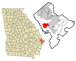
Location in Chatham County and the state of Georgia
|
|
| Country | United States |
| State | Georgia |
| Counties | Chatham |
| Area | |
| • Total | 8.87 sq mi (22.96 km2) |
| • Land | 8.24 sq mi (21.34 km2) |
| • Water | 0.62 sq mi (1.61 km2) |
| Elevation | 13 ft (4 m) |
| Population
(2020)
|
|
| • Total | 11,916 |
| • Density | 1,445.94/sq mi (558.27/km2) |
| FIPS code | 13-32482 |
| GNIS feature ID | 1694531 |
Georgetown is a community in Chatham County, Georgia, United States. It is called an "unincorporated community" and a "census-designated place" (CDP). This means it's a recognized area with its own identity, but it's not officially a city with its own local government.
In 2020, about 11,916 people lived in Georgetown. It is located near the Little Ogeechee River, just across from the city of Savannah, Georgia. Many adults who live in Georgetown work in Savannah, making Georgetown a "bedroom community." It is also part of the larger Savannah Metropolitan Statistical Area.
Georgetown was mostly built in the late 1970s and early 1980s. However, new neighborhoods are still being added today. There are now many more places to shop, and new stores continue to open.
Contents
Schools in Georgetown
Georgetown has schools that are part of the Savannah-Chatham public school system.
- Georgetown Elementary School
- Southwest Middle School
Students living in Georgetown who are in high school usually go to Windsor Forest High School in Savannah.
Geographic Location
Georgetown is located in the western part of Chatham County. Its exact coordinates are 31.979612 degrees north and 81.232118 degrees west.
The community is surrounded by parts of the city of Savannah on its east, south, and west sides. Over time, Savannah has grown and taken in some areas that used to be part of Georgetown. To the northwest of Georgetown is another community called Henderson.
U.S. Route 17 runs along the northwestern edge of Georgetown. This road can take you about 11 miles (18 km) northeast to downtown Savannah. If you go southwest on U.S. Route 17, you'll reach Richmond Hill in about 5 miles (8 km). Another road, Veterans Parkway, starts in eastern Georgetown and also leads about 11 miles (18 km) to the center of Savannah.
Area Size
The United States Census Bureau reports that Georgetown covers a total area of about 8.8 square miles (22.7 square kilometers). Most of this area, about 8.2 square miles (21.3 square kilometers), is land. The remaining part, about 0.6 square miles (1.4 square kilometers), is water. This means about 6.30% of Georgetown's total area is water.
Population Information
Georgetown was first recognized as a census-designated place (CDP) in the 1980 U.S. Census. Since then, its population has grown steadily.
| Historical population | |||
|---|---|---|---|
| Census | Pop. | %± | |
| 1980 | 2,785 | — | |
| 1990 | 5,554 | 99.4% | |
| 2000 | 10,599 | 90.8% | |
| 2010 | 11,823 | 11.5% | |
| 2020 | 11,916 | 0.8% | |
| U.S. Decennial Census 1850-1870 1870-1880 1890-1910 1920-1930 1940 1950 1960 1970 1980 1990 2000 2010 2020 |
|||
Population in 2020
The 2020 United States census counted 11,916 people living in Georgetown. There were 4,971 households and 3,741 families in the community.
The table below shows the different racial and ethnic groups living in Georgetown over the years. The U.S. Census counts Hispanic/Latino as a separate ethnic group, and people from this group can be of any race.
| Race / Ethnicity (NH = Non-Hispanic) | Pop 2000 | Pop 2010 | Pop 2020 | % 2000 | % 2010 | 2020 |
|---|---|---|---|---|---|---|
| White alone (NH) | 7,458 | 6,876 | 5,736 | 70.37% | 58.16% | 48.14% |
| Black or African American alone (NH) | 2,093 | 3,216 | 3,930 | 19.75% | 27.20% | 32.98% |
| Native American or Alaska Native alone (NH) | 35 | 35 | 24 | 0.33% | 0.30% | 0.20% |
| Asian alone (NH) | 325 | 409 | 374 | 3.07% | 3.46% | 3.14% |
| Pacific Islander alone (NH) | 4 | 20 | 29 | 0.04% | 0.17% | 0.24% |
| Some Other Race alone (NH) | 22 | 28 | 59 | 0.21% | 0.24% | 0.50% |
| Mixed Race or Multi-Racial (NH) | 172 | 317 | 585 | 1.62% | 2.68% | 4.91% |
| Hispanic or Latino (any race) | 490 | 922 | 1,179 | 4.62% | 7.80% | 9.89% |
| Total | 10,599 | 11,823 | 11,916 | 100.00% | 100.00% | 100.00% |
Images for kids
See also
 In Spanish: Georgetown (Georgia) para niños
 | Emma Amos |
 | Edward Mitchell Bannister |
 | Larry D. Alexander |
 | Ernie Barnes |


