Gerald, Missouri facts for kids
Quick facts for kids
Gerald, Missouri
|
|
|---|---|

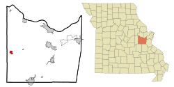
Location of Gerald, Missouri
|
|
| Country | United States |
| State | Missouri |
| County | Franklin |
| Area | |
| • Total | 1.49 sq mi (3.85 km2) |
| • Land | 1.48 sq mi (3.83 km2) |
| • Water | 0.01 sq mi (0.02 km2) |
| Elevation | 906 ft (276 m) |
| Population
(2020)
|
|
| • Total | 1,361 |
| • Density | 920.84/sq mi (355.61/km2) |
| Time zone | UTC-6 (Central (CST)) |
| • Summer (DST) | UTC-5 (CDT) |
| ZIP code |
63037
|
| Area code(s) | 573 |
| FIPS code | 29-26866 |
| GNIS feature ID | 2394884 |
Gerald is a small city located in western Franklin County, Missouri, United States. In 2020, about 1,361 people lived there. It is a quiet place with a friendly community feel.
Contents
History of Gerald
Gerald was officially started in 1901. It was built along a railroad line, which was very important for towns back then. The city got its name from a local family called Fitzgerald.
A post office has been open in Gerald since 1901, helping people send and receive mail. Two important historical places in Gerald are the Christian and Anna Keller Farmstead and the Old Gerald School. These buildings are listed on the National Register of Historic Places, which means they are special and protected.
Geography and Location
Gerald is located in Missouri, along a major road called US Route 50. It is about two miles east of the border between Franklin County and Gasconade County.
If you travel west from Gerald on Route 50, you'll find Rosebud about four miles away. If you go east, Leslie is about five miles away.
Size of the City
According to the United States Census Bureau, the city of Gerald covers a total area of about 1.49 square miles (3.85 square kilometers). Most of this area, about 1.48 square miles (3.83 square kilometers), is land. A very small part, about 0.01 square miles (0.02 square kilometers), is water.
Population and People
The number of people living in Gerald has changed over the years. Here's how the population has grown:
| Historical population | |||
|---|---|---|---|
| Census | Pop. | %± | |
| 1910 | 225 | — | |
| 1920 | 246 | 9.3% | |
| 1930 | 344 | 39.8% | |
| 1940 | 371 | 7.8% | |
| 1950 | 429 | 15.6% | |
| 1960 | 474 | 10.5% | |
| 1970 | 762 | 60.8% | |
| 1980 | 921 | 20.9% | |
| 1990 | 888 | −3.6% | |
| 2000 | 1,171 | 31.9% | |
| 2010 | 1,345 | 14.9% | |
| 2020 | 1,361 | 1.2% | |
| U.S. Decennial Census | |||
Gerald's Community in 2010
In 2010, there were 1,345 people living in Gerald. These people lived in 527 different homes, and 356 of these were families. The city had about 908 people living in each square mile.
Most of the people living in Gerald in 2010 were White (97.5%). There were also small numbers of African American, Native American, and Asian residents. Some people identified with two or more backgrounds. A small percentage of the population was Hispanic or Latino.
Many homes (34%) had children under 18 living there. About 45.5% of homes were married couples. Other homes included single parents or individuals living alone. The average home had about 2.5 people, and the average family had nearly 3 people.
The average age of people in Gerald was about 36.6 years old. About 24.5% of residents were under 18, and 14.9% were 65 or older. The population was almost evenly split between males (48.2%) and females (51.8%).
Education in Gerald
Gerald has a local library called the Gerald Area Library. This library lends out books and other materials to the community.
See also
 In Spanish: Gerald (Misuri) para niños
 | Percy Lavon Julian |
 | Katherine Johnson |
 | George Washington Carver |
 | Annie Easley |

