
Geraldine, New Zealand facts for kids
Quick facts for kids
Geraldine
Heratini (Māori)
|
|
|---|---|
|
Town
|
|

Talbot St (New Zealand State Highway 79) in Geraldine
|
|
| Country | New Zealand |
| Region | Canterbury |
| Territorial authority | Timaru District |
| Community board | Geraldine Community Board |
| Ward | Geraldine |
| Electorates |
|
| Area | |
| • Total | 3.22 km2 (1.24 sq mi) |
| Elevation | 120 m (390 ft) |
| Population
(June 2023)
|
|
| • Total | 2,970 |
| • Density | 922.4/km2 (2,389/sq mi) |
| Time zone | UTC+12 (New Zealand Standard Time) |
| • Summer (DST) | UTC+13 (New Zealand Daylight Time) |
| Postcode |
7930
|
| Area code(s) | 03 |
| Local iwi | Ngāi Tahu |
Geraldine (called Heratini in Māori) is a lovely town in the Canterbury area of New Zealand's South Island. It's about 140 km south of Christchurch. You'll find it inland from Timaru, which is 38 km to the south. Geraldine sits between the Orari and Hae Hae Te Moana Rivers. It is also 45 kilometres east of Fairlie.
Contents
History of Geraldine
There is proof that Māori travelled through the Geraldine area long ago. Old tools and carvings have been found in nearby places like Beautiful Valley and Kakahu. This land was part of a huge purchase by the Crown (the government) from the Ngāi Tahu people in 1848.
Early Settlers and Naming
After the land was bought, surveyors like Charles Torlesse visited the area. In 1854, Thomas Cass and Guise Brittan suggested a town site at Talbot Forest. Samuel Hewlings built a temporary hut there. A tōtara tree he planted for his daughter still stands today.
The first permanent residents were Alfred Cox and William du Moulin. The town was first called Fitzgerald in 1857. This was to honour James FitzGerald, the first leader of the Canterbury Province. Later, the name was changed to Geraldine. The exact reason for this change is not fully known.
Town Growth and Development
At first, Geraldine grew slowly. Other small settlements like Healey Town and German Town formed nearby. By 1862, most main streets were named. The area officially became a town in 1867.
In those early days, cutting timber was a main business. There were also many sheep farms. As the timber ran out, farming became the most important way to make money. In December 1904, Geraldine officially became a borough, which is a type of town with its own local government.
Exploring Geraldine's Surroundings
Talbot Forest Scenic Reserve
Right near the town centre is Talbot Forest Scenic Reserve. This forest is what's left of a huge native forest that used to cover Geraldine. It has many native trees like mataī, kahikatea, and tōtara. One tōtara tree is thought to be 800 years old!
Native Bush Reserves Nearby
The Geraldine area has several other native reserves you can drive to. These include Kakahu Bush Reserve, Orari Gorge Scenic Reserve, and Peel Forest Park Scenic Reserve. They are great places to explore nature.
New Zealand Long-tailed Bats
Did you know there are native long-tailed bats living around Geraldine? You can find colonies in places like Talbot Forest. In 2019, the Geraldine Festival even had a "Geraldine's Gone Batty" theme to celebrate these special creatures!
Education in Geraldine
Geraldine has two schools for young people:
- Geraldine Primary School is a state school for younger students. It has about 296 students (as of October 2022).
- Geraldine High School opened in 1963. It's a state high school for students from Year 7 to Year 13. It has about 605 students (as of October 2022).
Geraldine's Population
Geraldine covers about 3.22 square kilometres. As of 2018, it had an estimated population of 2,706 people. This means there were about 840 people living in each square kilometre.
The town's population has grown over the years:
| Historical population | ||
|---|---|---|
| Year | Pop. | ±% p.a. |
| 2006 | 2,397 | — |
| 2013 | 2,400 | +0.02% |
| 2018 | 2,706 | +2.43% |
In 2018, there were 1,173 households in Geraldine. The population included 1,254 males and 1,449 females. About 18.4% of the people were under 15 years old. Most people in Geraldine are of European/Pākehā background (94.7%). About 7.2% identify as Māori.
Entertainment and Media

You can watch movies at the historic Geraldine Cinema. It opened in 1924 and is on Talbot Street. This building used to be the Geraldine Town Hall. It was also the first building in Geraldine to have electricity!
Geraldine has its own radio station called Just Country FM. It broadcasts from the town.
Fun Amenities in Town
Golf Courses
If you like golf, Geraldine has two courses: The Geraldine District Golf Course and the Grande Vue Golf Course.
Geraldine Summer Pool
The Geraldine summer pool is an outdoor pool. It's open from November to March each year on Cox Street. The pool complex has a heated 25-metre swimming pool. There's also a learners' pool and a toddlers' pool. The Geraldine Amateur Swimming Club uses this pool for lessons and competitions.
Geraldine Domain Park
The Geraldine Domain is a large park over eleven hectares in size. It's located between Cox Street and Talbot Street. The domain has a playground, gardens, and sports fields. You can play cricket, football, tennis, netball, and bowls here. There are plans to add an artificial turf for hockey training.
Geraldine Library
The Geraldine library is at 80 Talbot Street. It's open Monday to Friday and on Saturday mornings. The library was recently updated in late 2021. It got new paint and carpet, its first big update since it opened in 2003.
Geraldine's Economy
Farming and Agriculture
The farming industry is very important to Geraldine's economy. In the past, sheep farming was common. Now, there are many dairy farms. But there are still farms that grow crops, raise deer, sheep, and beef cattle.
Many local businesses help support the farms. Large food processing companies like Fonterra and Barkers of Geraldine are in the area. Barker's of Geraldine is famous for growing fruit and making jams, sauces, and juices.
Tourism in Geraldine
Geraldine is a popular stop for tourists. Many people travelling from Christchurch to places like Queenstown or Wānaka pass through here. The town has many cafes, restaurants, and shops for visitors. You can also find tour operators who offer activities like rafting and horse trekking.
Museums to Explore
Geraldine Vintage Car & Machinery Museum
This museum has over 1400 cool exhibits! You can see 101 tractors, a 1929 Spartan biplane, and more than 50 vintage cars. It's located at 178 Talbot Street. They recently added a new display with pedal cars and miniature trains.
Route 79 Museum
The Route 79 Museum is just outside Geraldine on Craig Road. It has old motorbikes, horse buggies, and even a 1963 Australian Army truck.
Geraldine Historical Museum
The Geraldine Historical Museum shows the history of the Geraldine area. It's located on Cox Street in the old Town Board Office building.
Churches in Geraldine
Saint Andrew's Presbyterian Church
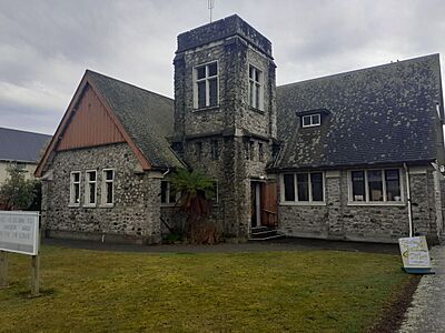
Saint Andrew's Presbyterian Church is on 10 Cox Street. This church is built from local stone and opened in 1950.
Saint Mary's Anglican Church
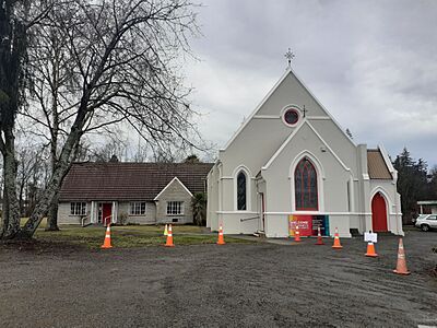
Saint Mary's Anglican Church is at 77 Talbot Street. The first Anglican church in Geraldine was built in 1864. The current church was built in 1899. It is listed as a Category Two historic place by Heritage New Zealand.
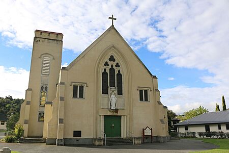
Immaculate Conception Catholic Church
The Catholic Church, called St Mary Mackillop Parish – Immaculate Conception Church, is on 19 Hislop Street. It opened in 1935 and cost £10,000 to build. The church can seat up to 300 people. Its altar is made of Oamaru stone.
- Geraldine churches
-
Church of the Immaculate Conception
-
St Andrew's Presbyterian Church
-
St Mary's Anglican Church


Historic Buildings of Geraldine
Town Board Office
The Town Board Office on Cox Street is now part of the Geraldine Historical Museum. It was first built in 1885 on Talbot Street. It cost 269 pounds to build. When Geraldine became a borough in 1905, this building was used by the Borough Council. It was moved to Cox Street in 1975 to become part of the museum. The building is made of bluestone.
McKechnie's Cottage
This small cottage on Wilson Street was built in 1873. It is one of the oldest buildings in Geraldine. It was a tailor's shop for a few years. Douglas McKechnie bought it in 1941 and lived there for 47 years. He was also the mayor of Geraldine from 1939 to 1949.

Crown Hotel
The Crown Hotel is now known as the Geraldine Heritage Hotel. It's at 31 Talbot Street. The original building burned down. The current building was built in 1906. It is listed as a Category Two historic place.

St Mary's Vicarage
The St Mary's vicarage is on Talbot Street. This beautiful Arts and Crafts style house was built in 1900. It was restored in 2019. It is also listed as a Category Two historic place.

Old Post Office Building
The post office building opened in November 1908. It was opened by the prime minister, Sir Joseph Ward. The two-story building had a mail room and offices downstairs. The postmaster lived upstairs. In 1997, the post office moved. The building was sold in 2005. It has been used by different shops since then. It is a Category Two historic place.

Other Heritage Buildings
Geraldine has other buildings listed as Category Two heritage places. These include:
- Brick Cottage, 137 Talbot Street
- Corner shop (Talbot Street)
- Corner shop cottage (Talbot Street)
- Geraldine Co-operative Cheese Factory (Pleasant Valley Road)

Notable People from Geraldine
Many interesting people have connections to Geraldine, including:
- John Badcock, an artist
- Mark Inglis, a mountaineer
- Jordan Luck, a musician
- Hayden Paddon, a rally driver
- Annabel Ritchie, a rower
- Gus Spillane, a former All Black (rugby player)
- Peter Williams, a broadcaster
Climate in Geraldine
| Climate data for Geraldine (Orari Estate) (1991–2020 normals, extremes 1972–present) | |||||||||||||
|---|---|---|---|---|---|---|---|---|---|---|---|---|---|
| Month | Jan | Feb | Mar | Apr | May | Jun | Jul | Aug | Sep | Oct | Nov | Dec | Year |
| Record high °C (°F) | 38.3 (100.9) |
38.5 (101.3) |
34.5 (94.1) |
31.7 (89.1) |
27.3 (81.1) |
23.0 (73.4) |
22.0 (71.6) |
24.0 (75.2) |
28.4 (83.1) |
31.0 (87.8) |
33.3 (91.9) |
35.4 (95.7) |
38.5 (101.3) |
| Mean maximum °C (°F) | 31.9 (89.4) |
31.0 (87.8) |
29.2 (84.6) |
24.9 (76.8) |
21.7 (71.1) |
17.8 (64.0) |
18.1 (64.6) |
20.2 (68.4) |
23.2 (73.8) |
25.7 (78.3) |
27.7 (81.9) |
29.9 (85.8) |
33.4 (92.1) |
| Mean daily maximum °C (°F) | 22.1 (71.8) |
21.7 (71.1) |
20.0 (68.0) |
16.9 (62.4) |
14.0 (57.2) |
11.2 (52.2) |
10.8 (51.4) |
12.5 (54.5) |
15.0 (59.0) |
16.8 (62.2) |
18.5 (65.3) |
20.5 (68.9) |
16.7 (62.0) |
| Daily mean °C (°F) | 16.3 (61.3) |
16.0 (60.8) |
14.2 (57.6) |
11.2 (52.2) |
8.5 (47.3) |
5.7 (42.3) |
5.2 (41.4) |
6.8 (44.2) |
9.0 (48.2) |
10.9 (51.6) |
12.7 (54.9) |
14.9 (58.8) |
11.0 (51.7) |
| Mean daily minimum °C (°F) | 10.5 (50.9) |
10.3 (50.5) |
8.4 (47.1) |
5.6 (42.1) |
3.0 (37.4) |
0.3 (32.5) |
−0.4 (31.3) |
1.2 (34.2) |
3.1 (37.6) |
5.0 (41.0) |
6.8 (44.2) |
9.2 (48.6) |
5.3 (41.5) |
| Mean minimum °C (°F) | 4.4 (39.9) |
4.2 (39.6) |
2.1 (35.8) |
0.1 (32.2) |
−2.1 (28.2) |
−4.5 (23.9) |
−4.9 (23.2) |
−4.1 (24.6) |
−2.3 (27.9) |
−0.6 (30.9) |
1.0 (33.8) |
3.6 (38.5) |
−5.8 (21.6) |
| Record low °C (°F) | 2.0 (35.6) |
1.3 (34.3) |
−1.6 (29.1) |
−3.2 (26.2) |
−7.4 (18.7) |
−7.9 (17.8) |
−7.4 (18.7) |
−7.2 (19.0) |
−4.0 (24.8) |
−3.1 (26.4) |
−1.3 (29.7) |
0.4 (32.7) |
−7.9 (17.8) |
| Average rainfall mm (inches) | 56.1 (2.21) |
61.3 (2.41) |
55.0 (2.17) |
64.5 (2.54) |
50.3 (1.98) |
53.8 (2.12) |
54.3 (2.14) |
58.1 (2.29) |
43.9 (1.73) |
56.6 (2.23) |
63.1 (2.48) |
60.1 (2.37) |
677.1 (26.67) |
| Source: NIWA | |||||||||||||
| Climate data for Geraldine (1981–2010) | |||||||||||||
|---|---|---|---|---|---|---|---|---|---|---|---|---|---|
| Month | Jan | Feb | Mar | Apr | May | Jun | Jul | Aug | Sep | Oct | Nov | Dec | Year |
| Mean daily maximum °C (°F) | 23.0 (73.4) |
22.1 (71.8) |
20.1 (68.2) |
17.8 (64.0) |
14.3 (57.7) |
11.6 (52.9) |
10.9 (51.6) |
12.5 (54.5) |
15.1 (59.2) |
17.0 (62.6) |
18.9 (66.0) |
20.7 (69.3) |
17.0 (62.6) |
| Daily mean °C (°F) | 16.9 (62.4) |
16.4 (61.5) |
14.4 (57.9) |
11.6 (52.9) |
8.6 (47.5) |
5.9 (42.6) |
5.2 (41.4) |
6.8 (44.2) |
9.3 (48.7) |
11.2 (52.2) |
13.2 (55.8) |
15.2 (59.4) |
11.2 (52.2) |
| Mean daily minimum °C (°F) | 10.8 (51.4) |
10.6 (51.1) |
8.6 (47.5) |
5.5 (41.9) |
2.8 (37.0) |
0.2 (32.4) |
−0.5 (31.1) |
1.2 (34.2) |
3.5 (38.3) |
5.5 (41.9) |
7.6 (45.7) |
9.8 (49.6) |
5.5 (41.8) |
| Average rainfall mm (inches) | 77.7 (3.06) |
77.2 (3.04) |
89.0 (3.50) |
71.1 (2.80) |
56.4 (2.22) |
46.6 (1.83) |
61.0 (2.40) |
64.3 (2.53) |
50.7 (2.00) |
65.1 (2.56) |
60.0 (2.36) |
77.1 (3.04) |
796.2 (31.34) |
| Source: NIWA (rain 1971–2000) | |||||||||||||
