
Glenelg East, South Australia facts for kids
Quick facts for kids Glenelg EastAdelaide, South Australia |
|||||||||||||||
|---|---|---|---|---|---|---|---|---|---|---|---|---|---|---|---|

Da Costa Reserve Glenelg East
|
|||||||||||||||
| Postcode(s) | 5045 | ||||||||||||||
| Location | 9 km (6 mi) from GPO | ||||||||||||||
| LGA(s) | City of Holdfast Bay | ||||||||||||||
| State electorate(s) | Morphett | ||||||||||||||
| Federal Division(s) | Boothby | ||||||||||||||
|
|||||||||||||||

Glenelg East is a suburb in Adelaide, South Australia. It is located about 9 kilometres south-west of the centre of Adelaide. This area has a mix of older, traditional homes and newer, modern houses. You can also find parks and some low-rise apartment buildings here.
Contents
Who Lives in Glenelg East?
In 2011, about 3,700 people lived in Glenelg East. The average age of residents was 41 years old. Around 14% of the people living here were children aged 14 or younger. About 16% were over 65 years old. Most people speak English at home. Other languages spoken include Greek, Italian, German, and Cantonese.
Where is Glenelg East Located?
Glenelg East has clear borders. To the north, it's next to Anzac Highway. Cliff Street forms its southern border. Brighton Road is to the west, and Buttrose Street is to the east.
Fun Things to Do in Glenelg East

Glenelg East is a great place for families because it's close to the beaches of Glenelg and Glenelg South. You can easily walk to them!
The suburb has several parks with cool features. These include playgrounds for kids, open spaces for running around, barbecue areas, and shelters. Some of the well-known parks are Da Costa, Sandison, Margaret Messenger, and Mel Baker Reserves.
If you like tennis, Glenelg East has two tennis clubs. You can find the Helmsdale Tennis Club at Sandison Reserve. The Holdfast Tennis Club is at Margaret Messenger Reserve.
The Glenelg Oval is a very popular sports ground. It's used for cricket and Australian Rules Football. This is the home ground for the SANFL Glenelg Football Club, also known as the "Tigers"!
Many people who love cycling meet up at a local coffee shop in Glenelg East. From there, they go for rides through Adelaide's beach suburbs on weekends.
Homes and History of Homes

The local council, the City of Holdfast Bay, has rules about building homes in Glenelg East. Most homes are meant to be single-storey. A second storey can be added if it fits in with the other buildings nearby. The rules also make sure that blocks of land are kept large, usually over 600 square metres. This helps keep the area from becoming too crowded.
A special part of the plan is to protect older, historic homes. There's a "Heritage Conservation Zone" around Da Costa Park. This zone helps keep the look of certain older house styles that are common in Glenelg East. These styles come from different time periods:
- Victorian (from the 1860s to 1900)
- Federation (from the 1890s to 1920)
- Inter War (from the 1920s to 1950s)
Da Costa Park Heritage Zone
You can see original and restored homes from these periods all over Glenelg East. They are especially common in the streets near the Da Costa Park Heritage Conservation Zone. The Tudor Revival and Californian Bungalow styles, built between the 1920s and 1950s, are the most common. You can also find a few examples of Federation Homes.
- Common Housing Styles in the suburb of Glenelg East
-
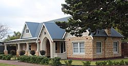
Restored Tudor Revival Da Costa Park
-
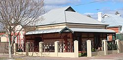
Federation Style Residence
-
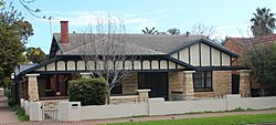
Californian Bungalow Style Residence

.JPG)

Schools in the Area
Glenelg Primary School is right in Glenelg East.
There are also two private schools nearby that you can walk to: St Peter's Woodlands Grammar School and Immanuel College.
Most of Glenelg East is also in the zone for Brighton Secondary School.
Getting Around Glenelg East


Glenelg East is close to major roads. It takes about 25 minutes to drive to the Adelaide city centre and about 15 minutes to the Adelaide Airport.
Buses run regularly along Anzac Highway and Brighton Road, making it easy to get around. The famous Glenelg tram line also runs through Glenelg East. There are four tram stops within the suburb. A tram ride to the city takes about 25 minutes.
The tram service started as a railway line in 1873. It became an electric tramway on December 14, 1929.
If you like cycling, the Mike Turtur Bikeway runs next to the tram line. It's a sealed path that's great for bike commuting. You can also cycle on quieter roads within the suburb.
History of Glenelg East

On November 23, 1947, the Glenelg Council decided to combine and rename several smaller areas into the suburbs we know today: Glenelg East, Glenelg, Glenelg North, and Glenelg South.
Glenelg East was created by joining four smaller settlements: Grovene, Helmsdale, Dunleath, and Da Costa Park. Grovene used to be part of the City of West Torrens, and Da Costa Park came from the Marion District Council. These changes were made based on official recommendations.
The first homes in the area were built after a large piece of land was divided up in 1911. This area was called Helmsdale. Later, between 1925 and 1926, more land in Dunleath was opened for building. People were very keen to buy land, with many blocks selling quickly.
Da Costa Park, now part of Glenelg East, is named after Benjamin Mendes Da Costa. He was an early resident of Adelaide who owned a lot of property. After he passed away, he left his land in South Australia to St Peter's College.
