Goffle Brook Park facts for kids
Quick facts for kids Goffle Brook Park |
|
|---|---|

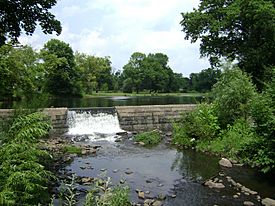
Arnold’s Pond in Goffle Brook Park, Hawthorne
|
|
| Type | County park |
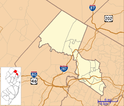
| Location | Hawthorne, New Jersey, USA |
| Area | 103 acres (42 ha) |
| Created | 1932 |
| Operated by | Passaic County Parks & Recreation |
| Open | All year |
| Built | 1932 |
| Architect | Olmsted Brothers |
| NRHP reference No. | 02001276 |
| Significant dates | |
| Added to NRHP | November 1, 2002 |
Goffle Brook Park is a public park in Hawthorne, Passaic County, New Jersey. It stretches along Goffle Brook and is a great place for outdoor fun. The park was built between 1930 and 1932. It helps protect the brook's water while offering many activities for people in Passaic and nearby Bergen County. Goffle Brook Park has been recognized as a historic place since 2002.
Contents
Discovering Goffle Brook Park's Past
This park was designed by Olmsted Associates, a famous landscape architecture firm. They were the successors to Frederick Law Olmsted's practice. The park was planned as a "greenway," which means it's a long, narrow area of green space. It helps connect different places and protects nature.
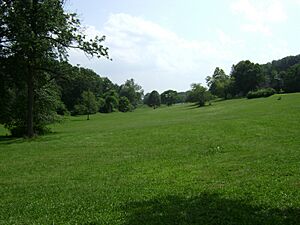
When it first opened, the park had wide, well-kept meadows, forests, and a former mill pond. Walking paths wound through these areas. Over the years, more features have been added for visitors. These include playgrounds, sports fields, and even a special area for dogs to run.
The town of Hawthorne also takes care of small trails in a section called the 8-Acre Woods. This area is at the park's southern end. Right next to Goffle Brook Park, Hawthorne High School has a large sports complex. It includes a football stadium, a running track, baseball fields, a hockey rink, and tennis courts.
A group of experts helped get Goffle Brook Park listed on the New Jersey and National Historic Places Registry. This means the park is important because of its history and design. They worked with a local group called the "Please Save Our Parkland Committee."
Park Improvements: The 2013 Project
In 2012, Passaic County started a big project to make Goffle Brook Park even better. This multi-year effort aimed to improve the park's beauty and health. It also worked to stabilize Goffle Brook and rebuild bridges over it.
By 2014, much of the work was done. The stream banks were made stronger throughout the park. One of the bridges was rebuilt. Many unhealthy or risky plants and trees were removed. These were mostly non-native trees like Norway Maples. New plants native to North America were used to strengthen the brook's banks. They were planted along with large rocks to protect the soil.
The project also created new paths for walking and jogging. New benches and trash cans were added for visitors. To replace the trees that were removed, over 400 new trees were planted. Five hundred new shrubs and plants were also added. These included different types of willow trees along the stream banks.
A Glimpse into the Colonial Era
Before the American Revolution, two Lenape Native American camps were located where the park is now. The larger camp was where Goffle Brook and Deep Voll Brook meet.
The area around Goffle Brook Park played an important role in the American Revolutionary War. For a time, General Lafayette’s troops were stationed along Goffle Brook. In 1780, Major Lee's Virginia light horse troop was on the east side of the brook. Lafayette's light infantry was on the west side, near First Watchung Mountain. Lafayette's main office was at the Ryerson House. You can find a marker for its former location on a small hill in the park's southern part.
Exploring Goffle Brook Park Today
Goffle Brook Park is a green and lively place. It sits at the eastern base of Goffle Hill (First Watchung Mountain). The park follows Goffle Brook for about a mile and a half. It stretches between Lafayette Avenue and MacFarlan Avenue/Maitland Avenue in Hawthorne.
Even though the park is not very wide, it offers amazing views from its hilly southern meadows. In winter, these hills are popular for sleigh riding. The southern part of the park also has a fenced-in dog run, several ball fields, and two playgrounds. You can also find a picnic area and wooded walking trails there.
The northern part of the park features Arnold's Pond. This used to be a pond for a grist mill, but now it's mainly used for fishing. Another main feature of the north end is a simple walking path that runs next to Goffle Brook. The path is paved around Arnold's Pond. However, it's mostly unpaved elsewhere, except for a concrete staircase. This staircase goes down into the brook's valley from the corner of Goffle Road and Warburton Avenue. The northern part of the park also has a playground and a ball field. These are near the corner of Goffle Road and Rea Avenue.
The Historic Magee Road Bridge
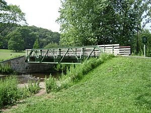
In 2007, the historic Magee Road Bridge was placed over Goffle Brook in the park's southern end. This bridge was originally built in 1930. It used to cross West Brook in Ringwood, New Jersey.
The bridge is made of steel and wood. It's an example of a special type of bridge design called a "pony truss." When the bridge was in Ringwood, it was considered important enough to be listed on the National Register of Historic Places.
See also
- National Register of Historic Places listings in Passaic County, New Jersey
- Garret Mountain Reservation, a nearby park designed by the Olmsted firm around the same time as Goffle Brook Park.
 | Janet Taylor Pickett |
 | Synthia Saint James |
 | Howardena Pindell |
 | Faith Ringgold |


