Golden Stair Mountain facts for kids
Quick facts for kids Golden Stair Mountain |
|
|---|---|
| Highest point | |
| Elevation | 2,405 feet (733 m) |
| Geography | |
| Location | N of Atwell, New York, U.S. |
| Topo map | USGS Bisby Lakes |
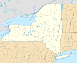
Golden Stair Mountain is a mountain peak, also called a summit, located in the central part of New York State. It stands tall in Herkimer County, specifically in the Town of Ohio. You can find it just north of a small place called Atwell.
This mountain reaches an elevation of about 2,405 feet (or 733 meters) above sea level. It's a notable point in the landscape of the Central New York Region.
What is Golden Stair Mountain?
Golden Stair Mountain is a natural high point in the land. When we say "summit," we mean the very top of a mountain. This mountain is part of the many hills and peaks found across New York State. It's not one of the highest mountains in the world, but it's an important feature in its local area.
Mountains like Golden Stair are formed over millions of years by natural forces. These forces include the movement of Earth's plates or the slow wearing away of land by wind and water.
Where is Golden Stair Mountain Located?
Golden Stair Mountain is situated in the middle of New York State. It's in a county called Herkimer County. If you look at a map, you'll find it north of a small community named Atwell.
To be very precise, its exact location can be described using special numbers called coordinates. These are like an address for a spot on Earth. For Golden Stair Mountain, the coordinates are 43 degrees, 34 minutes, 30 seconds North latitude and 74 degrees, 56 minutes, 21 seconds West longitude. These numbers help scientists and hikers find the mountain on detailed maps.
How Do We Map Mountains?
To understand mountains like Golden Stair, people use special maps called topographic maps. These maps show the shape of the land, including hills, valleys, and mountains. They use lines called contour lines to show how high or low the land is.
The USGS (United States Geological Survey) creates many of these maps. The map for Golden Stair Mountain is named Bisby Lakes. These maps are very useful for anyone who wants to explore the outdoors, understand the landscape, or study geography. They help us see how high a mountain is and how steep its sides are.
 | George Robert Carruthers |
 | Patricia Bath |
 | Jan Ernst Matzeliger |
 | Alexander Miles |


