Gordon Island facts for kids
|
Native name:
Isla Gordon
|
|
|---|---|

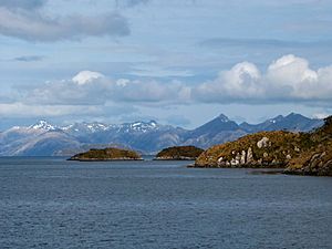
Gordon Island, seen from the Beagle Channel
|
|
| Geography | |
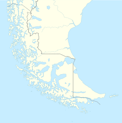
| Coordinates | 54°58′S 69°35′W / 54.967°S 69.583°W |
| Adjacent bodies of water | Beagle Channel, Pacific ocean |
| Area | 591 km2 (228 sq mi) |
| Coastline | 228.3 km (141.86 mi) |
| Highest point | 1548 |
| Administration | |
| Region | Magallanes |
| Province | Antártica Chilena |
| Commune | Cabo de Hornos |
| Additional information | |
| NGA UFI=-883298 | |
Gordon Island (Spanish: Isla Gordon) is an island in the Tierra del Fuego area, located in the southern part of Chile. It sits between the much larger Tierra del Fuego island and Hoste Island. This island is important because it divides the famous Beagle Channel into two smaller waterways: the Northwest arm (also called Pomar Channel) and the Southwest arm.
Contents
Island Geography and Location
Gordon Island is part of the Tierra del Fuego archipelago, which is a group of islands at the very tip of South America. It's found in the Magallanes Region of Chile, specifically in the Antártica Chilena Province. The island's position helps shape the flow of the Beagle Channel, a well-known waterway for ships.
Size and Features of Gordon Island
Gordon Island covers an area of about 591 square kilometers (228 square miles). To give you an idea, that's roughly the size of a large city! The highest point on the island reaches 1,548 meters (5,079 feet) above sea level. Its coastline stretches for about 228.3 kilometers (141.9 miles).
The Punta Divide Lighthouse
At the eastern end of Gordon Island, you'll find the Punta Divide lighthouse. Lighthouses are like beacons that help ships navigate safely, especially at night or in bad weather. This lighthouse guides vessels through the complex waterways of the Beagle Channel.
See also
 In Spanish: Isla Gordon para niños
- List of islands of Chile
- Cabo de Hornos
 | James Van Der Zee |
 | Alma Thomas |
 | Ellis Wilson |
 | Margaret Taylor-Burroughs |


