
Goumoëns facts for kids
Quick facts for kids
Goumoëns
|
||
|---|---|---|

Goumoens-la-Ville town hall
|
||
|
||

Goumoëns
Location in Switzerland

Goumoëns
Location in Canton of Vaud
|
||
| Country | Switzerland | |
| Canton | Vaud | |
| District | Gros-de-Vaud | |
| Area | ||
| • Total | 13.9 km2 (5.4 sq mi) | |
| Population
(Dec 2020 )
|
||
| • Total | 1,153 | |
| • Density | 82.9/km2 (214.8/sq mi) | |
| Surrounded by | Échallens, Penthéréaz, Saint-Barthélemy, Villars-le-Terroir | |

Goumoëns is a small town, or municipality, in Switzerland. It is located in the Vaud canton, which is like a state or region. Goumoëns was formed in 2011 when three smaller towns – Éclagnens, Goumoens-la-Ville, and Goumoens-le-Jux – decided to join together. It is a peaceful place known for its beautiful natural surroundings.
A Look Back in Time
The area that is now Goumoëns has a long history. The town of Éclagnens was first mentioned way back in 1265. It was called de Clanens then. Goumoens-la-Ville was first written about even earlier, in 1228, as Guimuens li vila. Goumoens-le-Jux appeared in records in 1447, known as Gumoens lo Jux.
During an older time in Switzerland, called the Ancien Régime, part of this area was known as Le Craux. These old names help us understand how the towns grew over many centuries.
Geography and Land Use
Goumoëns covers an area of about 13.89 square kilometers (5.36 sq mi). This is roughly 5.36 square miles. A large part of this land is used for farming. About 67.7% of the area, or 9.41 km2 (3.63 sq mi), is farmland.
Forests cover a good portion of Goumoëns too. Around 24.2% of the land, which is 3.36 km2 (1.30 sq mi), is covered by trees. The remaining land is used for buildings and roads, or it includes rivers and lakes. A very small part is unproductive land.
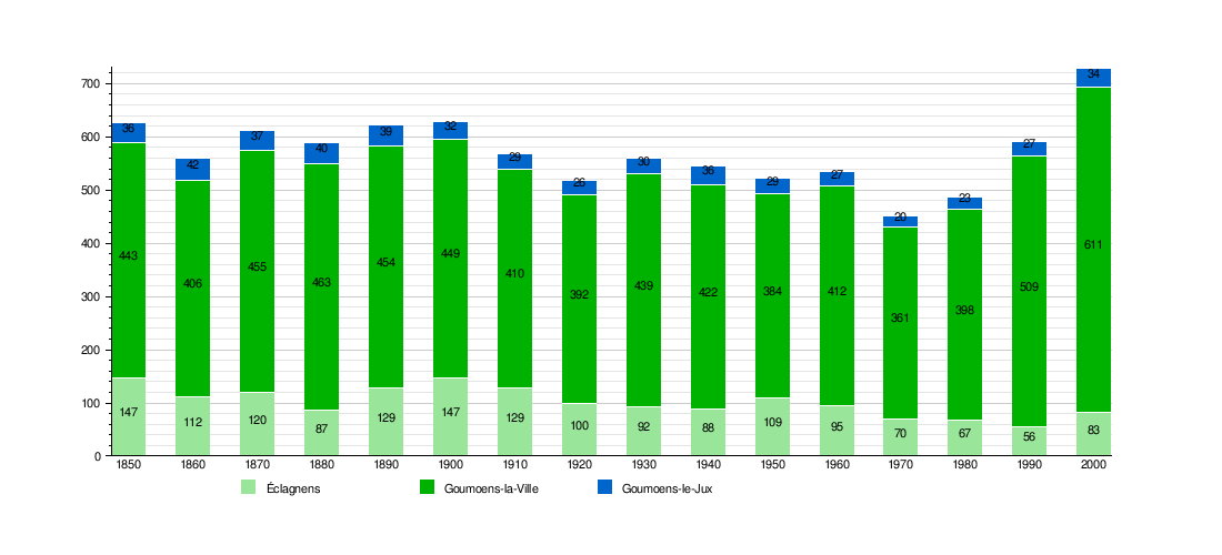
Population Over Time
The chart below shows how the number of people living in Éclagnens, Goumoens-la-Ville, and Goumoens-le-Jux changed over many years. You can see how the population of each town grew or shrunk before they all merged to form Goumoëns.
See also
 In Spanish: Goumoëns para niños
