
Grand Surrey Canal facts for kids
Quick facts for kids Grand Surrey Canal |
|
|---|---|

The Norway Cut swing bridge crosses a channel from Greenland Dock to the closed Norway dock
|
|
| Specifications | |
| Maximum boat length | 109 ft 0 in (33.22 m) |
| Maximum boat beam | 18 ft 0 in (5.49 m) |
| Locks | 1 |
| Status | Closed. Partly infilled. |
| History | |
| Date of act | 1801 |
| Date of first use | 1810 |
| Date completed | 1826 |
| Date closed | 1970s |
| Geography | |
| Start point | Camberwell |
| End point | Surrey Commercial Docks, Rotherhithe |
| Connects to | River Thames |
The Grand Surrey Canal was a waterway built in south London, England. It was constructed in the early 1800s. The canal opened in stages, reaching Old Kent Road in 1807, Camberwell in 1810, and Peckham in 1826. Its main job was to carry goods, especially timber, to the Surrey Commercial Docks.
The Grand Surrey Canal started closing down from the 1940s. By the 1970s, almost all of it was closed, except for the Greenland Dock. Today, you can still trace much of its path. Many parts have been turned into roads or long, narrow parks.
Contents
Building the Grand Surrey Canal
In the late 1700s, people had many ideas for canals south of the River Thames. Famous canal engineers like John Smeaton and John Rennie were involved. They looked at different routes and plans.
One idea was for a canal from Croydon to Wandsworth. However, engineers thought it might not work well. This was because it would need water from the River Wandle. This river already supplied many mills, and taking water for the canal could harm them.
Eventually, three big projects were suggested to the government. These were the Grand Surrey Canal, the Croydon Canal, and the Surrey Iron Railway. All three were approved in 1801.
The Grand Surrey Canal was officially approved on May 21, 1801. This was done through a special law called an Act of Parliament. This law created a company to build and run the canal. They were allowed to raise money to build it. The plan was to build a canal from Rotherhithe on the River Thames to Mitcham. It would also have smaller branches to other places like Deptford and Peckham.

Work on the canal began, but at the same time, new docks were being planned in London. In 1802, there was an idea to build a large dock at Rotherhithe. This dock would be close to where the canal met the Thames. The canal company decided to build this dock themselves in 1803.
Even though they didn't have much money, a large basin (a wide part of the canal) and a ship lock were finished. They opened on March 13, 1807. The Croydon Canal also wanted to connect to the Surrey Canal. This would save them from building their own path to the Thames. This connection helped the company open the first 3 miles (4.8 km) of the canal. This section reached the Old Kent Road in 1807. However, the company started to focus more on the docks, as they seemed more profitable.
In 1807, another Act of Parliament allowed them to raise more money. This money was used to extend the canal to Camberwell. This part was finished in 1810. So far, the canal had been flat. To go further, they would have needed locks or ramps, which cost a lot. So, the company didn't extend it much more. A short branch, about 0.5 miles (0.8 km) long, was built in 1826. It ran from Glengall Wharf to Peckham Basin. More laws were passed in 1808 and 1811 to get more money for the project.
Why the Canal Closed
In 1908, London's docks were reorganized. The canal became part of the Surrey Docks and was known as the Surrey Canal. Even though many railway bridges crossed it, trains didn't really compete with the canal. The canal continued to be busy until after the Second World War ended in 1945. After the war, road transport became much more popular.
The Camberwell basin and the last 500 yards (457 m) of the canal were closed in the 1940s. They were completely filled in by 1960. The timber trade to the docks stopped in the early 1970s. This led to the docks closing, and the rest of the canal was filled in.
What You Can See Today
The part of the canal between South Bermondsey and Deptford was turned into a road in the 1980s. It is now called Surrey Canal Road. Where the canal used to cross Trundleys Road, it became a private access road called Canal Approach. This road served warehouses and factories nearby.
Some of the old canal offices and buildings near Deptford Park were taken down. New apartments were built there. Part of the canal's route in the London Borough of Lewisham is now a park called the Surrey Canal Linear Park. Money from new housing projects helped build this park.
The former Camberwell Basin and about 0.9 miles (1.4 km) of the canal are now part of Burgess Park. A bridge built over the canal in 1906 is still in Burgess Park. It's sometimes called the "Bridge to Nowhere." Most of the Peckham branch is now a path for walking and cycling. It's known as the Surrey Canal Walk or Surrey Canal Linear Path. Peckham Library was built over the end of the Peckham basin. The Greenland Dock is still filled with water. It connects to the South Dock, which is now a marina. From there, boats can still reach the River Thames.
Points of Interest
| Point | Coordinates (Links to map resources) |
OS Grid Ref | Notes |
|---|---|---|---|
| Greenland Dock | 51°29′39″N 0°02′26″W / 51.4941°N 0.0405°W | TQ361790 | Still in water |
| Surrey Canal Road | 51°29′04″N 0°02′36″W / 51.4844°N 0.0432°W | TQ359779 | Built on line of canal |
| Mercury way | 51°29′03″N 0°02′51″W / 51.4843°N 0.0474°W | TQ356779 | Junction with Croydon Canal |
| Canal Grove | 51°29′02″N 0°03′51″W / 51.4839°N 0.0642°W | TQ345778 | Canal ran in front of houses |
| Peckham library | 51°28′29″N 0°04′10″W / 51.4746°N 0.0694°W | TQ341768 | Site of Peckham basin |
| Camberwell Park | 51°28′58″N 0°04′24″W / 51.4829°N 0.0732°W | TQ338777 | Junction with Peckham branch |
| Addington square | 51°28′52″N 0°05′32″W / 51.4811°N 0.0922°W | TQ325775 | Close to Albany Basin |
Images for kids
-
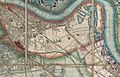
Grand Surrey Canal on Davies Pocket Map of London, 1852

