
Croydon Canal facts for kids
Quick facts for kids Croydon Canal |
|
|---|---|

A short section of the canal remains in Betts Park, Anerley
|
|
| Specifications | |
| Locks | 28 |
| Status | mostly destroyed |
| History | |
| Date of act | 1801 |
| Date of first use | 1809 |
| Date closed | 1836 |
| Geography | |
| Start point | Croydon |
| End point | New Cross |
| Connects to | Grand Surrey Canal |
The Croydon Canal was a waterway that used to run for about 15 kilometers (9.25 miles) in south London, England. It started in Croydon and went through places like Forest Hill before joining another canal called the Grand Surrey Canal at New Cross. The canal opened in 1809. It was one of the first canals to be officially closed down by a special law in 1836.
Contents
History of the Croydon Canal
Building the Canal
A special law, called an Act of Parliament, allowed the canal to be built in 1801. The original plan was for the canal to go all the way to Rotherhithe. However, another canal, the Grand Surrey Canal, was being built at the same time. This meant the Croydon Canal could connect to it instead, making things easier.
The canal was about 15 kilometers (9.25 miles) long. It officially opened on October 22, 1809.
Connecting to Railways
The Croydon Canal was linked to the Croydon, Merstham and Godstone Railway. This railway was also connected to the Surrey Iron Railway. These connections meant the canal could be used to move heavy things like stone and lime from mines in Merstham. There were plans to extend the canal further south to Epsom, but this never happened.
How the Canal Worked
The canal was first planned to have two sloped sections where boats could be pulled up or down. But instead, 28 special water lifts called locks were built. These locks were arranged in two groups. To make sure the canal always had enough water, large water storage areas called reservoirs were built. One was in Sydenham and another in South Norwood. The one in South Norwood is still there today as South Norwood Lake in a public park.
The canal was about 10 meters (34 feet) wide and up to 1.5 meters (5 feet) deep. By 1811, 22 barges were using the canal. These barges were about 18 meters (60 feet) long and 2.7 meters (9 feet) wide. They could carry around 30 tons of goods. The main thing they transported was timber (wood).
After the first groups of locks, most of the canal stayed at a height of about 49 meters (161 feet) above sea level.
The Pumping Station
The last two locks near Croydon Common raised the canal to a height of about 53 meters (174 feet). Because there wasn't a natural water source at this high point, a steam pumping station was built. Its job was to pump water up to the highest part of the canal.
In 1830, a new type of pumping engine was installed at Croydon Common. This was a gas vacuum engine, invented by Samuel Brown. It was probably the first commercial internal combustion engine ever used! This engine was quite clever. It used gas made by turning coal into coke. The coke and other things made from the coal were actually worth more than the cost of the coal itself. This meant the engine made a profit of over £100 a year, even before considering the useful work it did!
Why the Canal Closed
The Croydon Canal was never very successful. It officially closed in 1836. This made it the first canal in Britain to be closed by a special law from Parliament.
The London & Croydon Railway Company bought the canal for £40,250. They used much of the canal's path to build part of their railway line. This line ran between London Bridge and West Croydon station. The West Croydon station is actually built where the canal's main basin (a wide area for boats) used to be. The gas vacuum engine was still working well when it was put up for sale in 1837. It could lift water about 3.3 meters (11 feet) high at a rate of 2,000 gallons per minute.
What Remains Today
After the canal closed, some parts were kept for fun activities, like boating. The section in Betts Park in Anerley was used as a boating lake. This area was even called Anerley Tea Rooms. In 1934, this part of the canal was turned into a concrete channel. You can still see it in the northern part of Betts Park.
Another part of the canal still exists as a long, curved pond. This is in the Dacres Wood Nature Reserve in Forest Hill. In 1989, there were plans to build on this area. But research showed it was part of the old canal. Now, it's a nice wetland area and has been made wider again.
There's a raised path in David's Road, Forest Hill, which people think was part of the canal's towpath. A towpath is where horses would walk to pull the barges. Part of the wall below this path has been rebuilt with cool pictures showing different types of transport in Forest Hill.
The reservoir that supplied water to the canal in Norwood is now a preserved public park called South Norwood Lake.
Points of interest
| Point | Coordinates (Links to map resources) |
OS Grid Ref | Notes |
|---|---|---|---|
| Lock 10 | 51°28′17″N 0°02′11″W / 51.4715°N 0.0363°W | TQ364765 | New Cross |
| Bottom of Honor Oak flight | 51°27′52″N 0°02′14″W / 51.4645°N 0.0372°W | TQ364757 | Brockley |
| Top of Honor Oak flight | 51°26′59″N 0°02′54″W / 51.4498°N 0.0482°W | TQ357741 | Honor Oak |
| David's Road | 51°26′25″N 0°03′18″W / 51.4403°N 0.0549°W | TQ352730 | Raised towpath |
| Dacres Wood | 51°25′55″N 0°03′08″W / 51.4320°N 0.0523°W | TQ354721 | Nature reserve |
| Penge Wharf | 51°25′07″N 0°03′35″W / 51.4185°N 0.0598°W | TQ350706 | Penge |
| Anerley | 51°24′52″N 0°03′58″W / 51.4144°N 0.0661°W | TQ345701 | Tea rooms |
| Betts Park | 51°24′35″N 0°03′58″W / 51.4096°N 0.0660°W | TQ346696 | Concrete trough |
| South Norwood lake | 51°24′26″N 0°04′27″W / 51.4071°N 0.0742°W | TQ340693 | Feeder reservoir |
| Croydon Common Locks | 51°23′12″N 0°05′14″W / 51.3866°N 0.0871°W | TQ332670 | 2 locks |
| West Croydon Basin | 51°22′44″N 0°06′08″W / 51.3789°N 0.1022°W | TQ321661 | Terminus |
Gallery
-
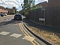
Modern roads built over and named for the canal
-
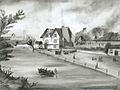
Anerley, 1860. This part of the canal remained, after closure, for pleasure boating


