
Grand Wash Cliffs facts for kids
Quick facts for kids Grand Wash Cliffs |
|
|---|---|

Grand Wash Cliffs at Meadview, Arizona
(view due-east) |
|
| Location | Mohave County, Arizona, Arizona, United States |
| Coordinates | 35°58′59″N 113°58′01″W / 35.983°N 113.967°W |
| Length | 115 ft (35 m) |
| Width | 5 ft (1.5 m) |
| Formed by | Colorado River |
The Grand Wash Cliffs are a very long line of cliffs in northwest Arizona, United States. They stretch for many miles, starting from the Grand Canyon–Parashant National Monument and going south into the Lake Mead Recreation Area. These cliffs are a huge natural feature. They even cross the famous Grand Canyon where the mighty Colorado River flows into Lake Mead. South of the Grand Canyon, the Grand Wash Cliffs continue, forming the edge of the Music Mountains. They are a truly impressive sight!
Contents
What Are the Grand Wash Cliffs?
The Grand Wash Cliffs are a type of landform called an escarpment. This means they are a long, steep slope or cliff that separates two areas of different heights. Think of them like a giant step in the landscape. They show where the land suddenly drops down.
Where Can You Find Them?
The Grand Wash Cliffs are located in Mohave County, Arizona. They run mostly north-to-south. Here are some of the places you might find along these cliffs:
- Grand Wash Cliffs Wilderness: This is a protected area at the northern end of the cliffs. It's a wild place where nature is preserved.
- Pearce Ferry: This spot is right where the Colorado River meets Lake Mead. The cliffs are a dramatic backdrop here.
- Meadview, Arizona: This small town is located near the foothills of the cliffs. You can get amazing views of the Grand Wash Cliffs from here.
- Music Mountains: These mountains are part of the larger Hualapai Plateau. The Grand Wash Cliffs form their western edge.
- Valentine, Arizona: This town is near the southern end of the cliffs.
How Were They Formed?
The Grand Wash Cliffs were formed over millions of years by powerful natural forces. The Colorado River played a big role in shaping the landscape around them. As the land slowly lifted up, the river and other natural processes, like erosion from wind and water, carved away the softer rock. This left behind the harder rock layers, creating the steep cliffs we see today. It's a great example of how geology can create amazing natural wonders!
Images for kids
-
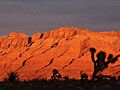
Sunset at Meadview with Joshua trees
-
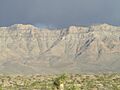
Cliffs, and foothills with Joshua Trees
-
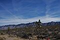
Grand Wash Cliffs, from Pierce Ferry Road


_January_2007_-_panoramio.jpg)
