Granger, Missouri facts for kids
Quick facts for kids
Granger, Missouri
|
|
|---|---|
|
Village
|
|

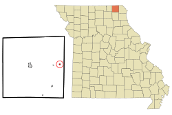
Location of Granger, Missouri
|
|
| Country | United States |
| State | Missouri |
| County | Scotland |
| Area | |
| • Total | 0.16 sq mi (0.41 km2) |
| • Land | 0.16 sq mi (0.41 km2) |
| • Water | 0.00 sq mi (0.00 km2) |
| Elevation | 755 ft (230 m) |
| Population
(2020)
|
|
| • Total | 22 |
| • Density | 138.36/sq mi (53.51/km2) |
| Time zone | UTC-6 (Central (CST)) |
| • Summer (DST) | UTC-5 (CDT) |
| ZIP code |
63442
|
| Area code(s) | 660 |
| FIPS code | 29-28360 |
| GNIS feature ID | 2398190 |
Granger is a small village located in Scotland County, Missouri, United States. In 2020, about 22 people lived there. It's a quiet place with a rich history.
History of Granger
Granger was planned and surveyed by Henry Hill in September 1874. The village got its name from the Grange Movement. This movement was very popular among farmers in rural America at that time.
Granger officially became a village on July 3, 1912. Back then, it was a busy place next to the Burlington Northern Railroad. The village had many businesses, including:
- three general stores
- two hotels
- a bank
- a drug store
- a hardware store
- a grocery store
- a meat market
- a barber shop
- a livery (where horses were kept)
- a blacksmith shop
Around 1910, it was estimated that between 150 and 200 people lived in Granger.
Granger's Geography
Granger is located entirely on land. According to the United States Census Bureau, the village covers a total area of about 0.41 square kilometers (0.16 square miles). There is no water area within the village limits.
Granger's Population
| Historical population | |||
|---|---|---|---|
| Census | Pop. | %± | |
| 1880 | 47 | — | |
| 1920 | 189 | — | |
| 1930 | 142 | −24.9% | |
| 1940 | 180 | 26.8% | |
| 1950 | 122 | −32.2% | |
| 1960 | 146 | 19.7% | |
| 1970 | 105 | −28.1% | |
| 1980 | 91 | −13.3% | |
| 1990 | 63 | −30.8% | |
| 2000 | 44 | −30.2% | |
| 2010 | 34 | −22.7% | |
| 2020 | 22 | −35.3% | |
| U.S. Decennial Census | |||
Population in 2010
In 2010, the village of Granger had 34 people living there. These people lived in 16 households, and 9 of these were families. The population density was about 138 people per square kilometer (212.5 people per square mile).
All of the residents in 2010 were White.
Out of the 16 households:
- About 18.8% had children under 18 years old.
- Half of the households (50%) were married couples living together.
- About 6.3% had a female head of household with no husband present.
- About 43.8% were made up of individuals living alone.
- About 18.8% of these individuals were 65 years old or older.
The average household had 2.13 people, and the average family had 3.00 people.
The average age of people in the village was 48 years old.
- 14.7% of residents were under 18.
- 11.8% were between 18 and 24.
- 14.7% were between 25 and 44.
- 35.2% were between 45 and 64.
- 23.5% were 65 or older.
The village had slightly more females (52.9%) than males (47.1%).
See also
 In Spanish: Granger (Misuri) para niños
 | James Van Der Zee |
 | Alma Thomas |
 | Ellis Wilson |
 | Margaret Taylor-Burroughs |

