Granville, North Dakota facts for kids
Quick facts for kids
Granville, North Dakota
|
|
|---|---|

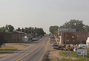
Looking south in Granville
|
|

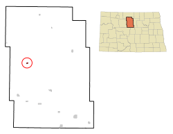
Location of Granville, North Dakota
|
|
| Country | United States |
| State | North Dakota |
| County | McHenry |
| Founded | 1900 |
| Incorporated | 1906 |
| Area | |
| • Total | 0.32 sq mi (0.83 km2) |
| • Land | 0.32 sq mi (0.82 km2) |
| • Water | 0.00 sq mi (0.01 km2) |
| Elevation | 1,509 ft (460 m) |
| Population
(2020)
|
|
| • Total | 240 |
| • Estimate
(2022)
|
230 |
| • Density | 757.10/sq mi (291.98/km2) |
| Time zone | UTC-6 (Central (CST)) |
| • Summer (DST) | UTC-5 (CDT) |
| ZIP code |
58741
|
| Area code(s) | 701 |
| FIPS code | 38-32660 |
| GNIS feature ID | 1029218 |
Granville is a small city in McHenry County, North Dakota, in the United States. In 2020, about 240 people lived there. It's part of the wider Minot area. Granville was started in the year 1900.
Contents
History of Granville
Granville was planned out and officially created in 1900. The city got its name from Granville M. Dodge, who was important in building railroads. The railroad reached Granville in 1904, and the city officially became a city in 1906.
In the late 1990s, the town made a fun, temporary change. It agreed to be called McGillicuddy City for a short time. This was part of a special promotion.
Geography and Location
Granville is located in North Dakota at these coordinates: 48.266566 degrees North and -100.843355 degrees West.
The United States Census Bureau says the city covers a total area of about 0.28 square miles (0.73 square kilometers). All of this area is land.
People of Granville: Demographics
| Historical population | |||
|---|---|---|---|
| Census | Pop. | %± | |
| 1910 | 455 | — | |
| 1920 | 394 | −13.4% | |
| 1930 | 450 | 14.2% | |
| 1940 | 443 | −1.6% | |
| 1950 | 404 | −8.8% | |
| 1960 | 400 | −1.0% | |
| 1970 | 282 | −29.5% | |
| 1980 | 281 | −0.4% | |
| 1990 | 236 | −16.0% | |
| 2000 | 286 | 21.2% | |
| 2010 | 241 | −15.7% | |
| 2020 | 240 | −0.4% | |
| 2022 (est.) | 230 | −4.6% | |
| U.S. Decennial Census 2020 Census |
|||
Population in 2010
In 2010, the city had 241 people living in 109 households. About 65 of these were families. The city had a population density of about 860 people per square mile (332 people per square kilometer).
The average age of people in Granville in 2010 was 44.3 years. About 21.6% of the residents were under 18 years old. Also, 19.9% of the people were 65 years old or older. The population was almost evenly split between males (50.2%) and females (49.8%).
Climate in Granville
Granville has a type of climate called a humid continental climate. This means it has big changes in temperature throughout the year. Summers are warm to hot, and often humid. Winters are cold, and sometimes very cold. On climate maps, this is shown as "Dfb".
Granville, North Dakota, holds a special weather record! On February 21, 1918, the temperature in Granville rose an amazing 83 degrees Fahrenheit in just 12 hours. It went from a very cold -33 °F (-36 °C) in the early morning to a much warmer 50 °F (10 °C) by late afternoon!
Historic Places to See
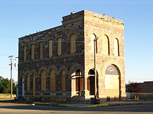
The Granville State Bank building is on Main Street. It was built in 1903. This building is special because it's listed on the National Register of Historic Places. This means it's an important historical site that is protected.
Transportation Options
The Amtrak train called the Empire Builder goes through Granville. This train travels between Seattle/Portland and Chicago. However, it does not stop in Granville. The closest train station is in Minot, which is about 23 miles (37 kilometers) to the west.
See also
 In Spanish: Granville (Dakota del Norte) para niños


