
Gray Wolf Ridge facts for kids
Quick facts for kids Gray Wolf Ridge |
|
|---|---|

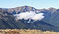
Gray Wolf Ridge (top) seen from Buckhorn Mountain
|
|
| Highest point | |
| Elevation | 7,218 ft (2,200 m) NGVD 29 |
| Geography | |
| Parent range | Olympic Mountains |
| Topo map | USGS Mount Deception |
Gray Wolf Ridge is a cool mountain ridge located in the northeastern part of the Olympic Mountains in Washington State. It's like a long arm reaching out from a group of big mountains, including Mount Deception, Needles, Mount Clark, and Mount Walkinshaw.
The lower parts of Gray Wolf Ridge are covered with thick forests. As you go higher, the trees become smaller and eventually disappear at the timberline. The very top of the ridge has six rocky peaks with only delicate alpine meadows growing there. The sides of the ridge are very steep. A main path called the Maynard Burn Trail (#816) helps people explore the ridge. The higher, western part of Gray Wolf Ridge is inside Olympic National Park.
Peaks of Gray Wolf Ridge
The highest point on Gray Wolf Ridge is Gray Wolf Mountain. It stands tall at about 7,218 feet (2,200 meters) above sea level. A climber named Leigh B. Lint was the first person to reach its top in 1928.
Other important peaks on the ridge include:
- '7076' (which is 7,076 feet tall)
- Baldy (6,797 feet tall)
- Tyler Peak (6,364 feet tall)
- Maynard Peak (5,065 feet tall), which is at the very end of the ridge to the northeast.
Rivers Around the Ridge
Several rivers flow through the valleys around Gray Wolf Ridge. The Gray Wolf River runs through the valley to the north of the ridge. Royal Creek and the Dungeness River flow through the valleys along the east and south sides of the ridge. These rivers help shape the landscape around the mountains.
Images for kids
-
Gray Wolf Ridge from the southeast. Baldy to right.
-
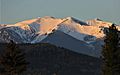
Baldy from the town of Sequim


