
Mount Deception (Washington) facts for kids
Quick facts for kids Mount Deception |
|
|---|---|

Mount Deception
|
|
| Highest point | |
| Elevation | 7,788 ft (2,374 m) |
| Prominence | 4,108 ft (1,252 m) |
| Geography | |

Mount Deception
Location in Washington (state)
|
|
| Location | Jefferson County, Washington, United States |
| Parent range | Olympic Mountains |
| Geology | |
| Age of rock | Eocene |
| Type of rock | Basalt |
| Climbing | |
| Easiest route | YDS 2 |
Mount Deception is a tall mountain in the Olympic Mountains range. It is located inside Olympic National Park on the Olympic Peninsula in the state of Washington, United States.
Contents
About Mount Deception
Mount Deception stands 7,788 feet (2,374 m) high. This makes it the second highest peak in the Olympic Mountains. Only Mount Olympus is taller. Mount Deception is the highest mountain in the eastern part of the Olympics.
This mountain has a prominence of 4,108 feet (1,252 m). This means it rises very high above the land around it. It is the 17th most prominent peak in all of Washington state. Mount Olympus is its closest taller neighbor, about 21.79 mi (35.07 km) to the west.
Where is Mount Deception Located?
Mount Deception is in the northeast part of the Olympic Mountains. It sits just northeast of Mount Mystery. It is found between Deception Creek and Royal Creek. This area is known as Royal Basin. Mount Deception is at the very top of Royal Basin.
Because of its location, Mount Deception is in the rain shadow of the Olympics. This means it gets much less rain and snow. The western Olympics and Mount Olympus get a lot more precipitation. Even though it's the tallest in the eastern Olympics, you cannot see Mount Deception from Seattle.
Nearby Peaks and Features
Many other peaks and features surround Mount Deception. To the north are Gilhooley Tower, The Needles, Mount Clark (7,528 ft or 2,295 m), and Mount Walkinshaw (7,378 ft or 2,249 m). There is also a ridge called Gray Wolf Ridge that runs northeast.
To the east and south, you can find Mount Fricaba, Hal Foss Peak, Mount Mystery, and Little Mystery. Mount Deception also has two small glaciers. These glaciers are found on the north side of the mountain, on its basalt slopes.
Rivers and Basins
Mount Deception sits on a natural boundary. This boundary separates the water flowing into the Dungeness River to the north. It also separates the water flowing into the Dosewallips River to the south and east. Deception Creek flows from the southern side of Mount Deception. This creek is a branch of the Dosewallips River.
Gray Wolf Pass is a mountain pass about 1 mile (1.6 km) west of Mount Deception. This pass connects the areas where water drains into the Dungeness and Dosewallips rivers.
History of Mount Deception
Mount Deception was once called Mount Holmes. The Seattle Press Expedition gave it this name to honor John H. Holmes. He worked for the Boston Herald newspaper.
Later, a person named G.A. Whitehead from the U.S. Forest Service changed its name. He renamed it Mount Deception. This was because climbers often found it hard to find safe routes up the mountain. The peak was also often covered by clouds, making it tricky to see.
Climbing Mount Deception

Climbing Mount Deception is not like hiking the peaks of Gray Wolf Ridge. Those can be climbed by fit hikers in a day. For Mount Deception, you need special mountaineering skills. It is a steep climb and can be dangerous.
The mountain has loose rocks and soft snow. If a climber falls, it can be hard to stop. People have been seriously hurt or even died on Mount Deception. The National Park Service suggests that climbers should be very good at stopping falls. They should also be skilled in rock climbing and finding their way.
The nearby Needles are also popular for climbing. Many climbers think they offer even better, and sometimes harder, challenges in the Royal Basin area.
Climate and Weather
Mount Deception is in a marine west coast climate zone. This means it has a climate similar to coastal areas in western North America. Most weather systems come from the Pacific Ocean. They travel northeast towards the Olympic Mountains.
As these weather systems reach the mountains, the peaks force them upward. This causes them to drop their moisture as rain or snow. This process is called Orographic lift. Because of this, the Olympics get a lot of rain and snow, especially in winter.
In winter, the weather is often cloudy. But in summer, high pressure systems over the Pacific Ocean bring clear skies. The best time to climb Mount Deception is usually from June through September.
Geology of the Mountain
The Olympic Mountains are made of different types of rock. They are mostly made of clastic material and oceanic crust. This includes Eocene sandstone, turbidite, and basaltic oceanic crust. These rocks were pushed up from under the ocean.
The mountains got their shape during the Pleistocene era. This was a time when glaciers moved forward and backward many times. These glaciers carved out the valleys and peaks we see today.
Images for kids
-
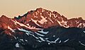
Sunrise on Mount Deception as seen from Marmot Pass

