
Graz-Umgebung District facts for kids
Quick facts for kids
Graz-Umgebung District
Bezirk Graz-Umgebung
|
|
|---|---|
| Country | Austria |
| State | Styria |
| Number of municipalities | 36 |
| Seat | Graz |
| Area | |
| • Total | 1,084.55 km2 (418.75 sq mi) |
| Population
(2023)
|
|
| • Total | 162,408 |
| • Density | 149.7469/km2 (387.8427/sq mi) |
| Time zone | UTC+01:00 (CET) |
| • Summer (DST) | UTC+02:00 (CEST) |
| Vehicle registration | GU |
| NUTS code | AT221 |
| Website | bh-grazumgebung.steiermark.at |
Bezirk Graz-Umgebung (say it: Grahts oom-GAY-boong) is a special area, like a county or district, in the country of Austria. It's part of the state called Styria. This district is super interesting because it forms a big ring all around Graz, which is the capital city of Styria! Graz is also where the main office for the district is located.
Towns and Villages in Graz-Umgebung
Since 2015, the district of Graz-Umgebung has been made up of 36 different towns and villages, which are called municipalities. These municipalities work together to manage the area around Graz.
Here are the municipalities that make up the district today:
- Deutschfeistritz
- Dobl-Zwaring
- Eggersdorf bei Graz
- Feldkirchen bei Graz
- Fernitz-Mellach
- Frohnleiten
- Gössendorf
- Gratkorn
- Gratwein-Straßengel
- Hart bei Graz
- Haselsdorf-Tobelbad
- Hausmannstätten
- Hitzendorf
- Kainbach bei Graz
- Kalsdorf bei Graz
- Kumberg
- Laßnitzhöhe
- Lieboch
- Nestelbach bei Graz
- Peggau
- Premstätten
- Raaba-Grambach
- Sankt Bartholomä
- Sankt Marein bei Graz
- Sankt Oswald bei Plankenwarth
- Sankt Radegund bei Graz
- Seiersberg-Pirka
- Semriach
- Stattegg
- Stiwoll
- Thal
- Übelbach
- Vasoldsberg
- Weinitzen
- Werndorf
- Wundschuh
Images for kids
-
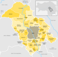
This map shows all the municipalities in the Graz-Umgebung district since 2015.

See also
 In Spanish: Distrito de Graz-Umgebung para niños

All content from Kiddle encyclopedia articles (including the article images and facts) can be freely used under Attribution-ShareAlike license, unless stated otherwise. Cite this article:
Graz-Umgebung District Facts for Kids. Kiddle Encyclopedia.