Greer, South Carolina facts for kids
Quick facts for kids
Greer
|
||
|---|---|---|

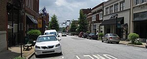
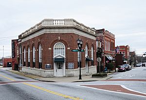
Downtown Greer
|
||
|
||
| Motto(s):
"A Great Place to Live, Work, and Play"
|
||
| Country | United States | |
| State | South Carolina | |
| Counties | Greenville, Spartanburg | |
| Founded | 1876 | |
| Named for | James Manning Greer | |
| Government | ||
| • Type | Council (weak mayor) | |
| Area | ||
| • Total | 25.56 sq mi (66.20 km2) | |
| • Land | 23.44 sq mi (60.71 km2) | |
| • Water | 2.12 sq mi (5.49 km2) 8.29% | |
| Elevation | 1,014 ft (309 m) | |
| Population
(2020)
|
||
| • Total | 35,308 | |
| • Estimate
(2023)
|
44,387 | |
| • Density | 1,506.38/sq mi (581.62/km2) | |
| Time zone | UTC−5 (Eastern (EST)) | |
| • Summer (DST) | UTC−4 (EDT) | |
| ZIP codes |
29650-29652
|
|
| Area code(s) | 864, 821 | |
| FIPS code | 45-30985 | |
| GNIS feature ID | 1245847 | |
Greer is a city in South Carolina, a state in the United States. It is located in both Greenville and Spartanburg counties. In 2020, about 35,308 people lived there. This makes Greer the 14th largest city in South Carolina. It is part of a larger area called the Greenville-Anderson-Greer Metropolitan Statistical Area.
Contents
- History of Greer: How the City Began
- Geography: Where is Greer Located?
- Population: Who Lives in Greer?
- Economy: What Does Greer Do for Work?
- Arts and Culture: Fun Things to Do in Greer
- Parks and Recreation: Places to Play
- Infrastructure: How Greer Works
- Education: Schools in Greer
- Notable People: Famous Folks from Greer
- See also
History of Greer: How the City Began
Greer was named after Scottish settler James Manning Greer. Many of his family members still live in the area today. James Manning Greer's family settled near Greenville. This area later became known as Greer's Station.
The land where Greer now stands was once part of the Cherokee Native American territory. In 1777, this land became part of South Carolina. The town started to grow in 1873. This happened when a railway line was built between Atlanta and Charlotte. A train station was built on James Manning Greer's land. It was called Greer's Station. The first post office was inside this new station. The station was a red brick building with a special roof. It was torn down in 1976.
When the town officially became a town in 1876, it was named "Town of Greer's." One hundred years later, its name was changed to the "City of Greer." The "s" was removed from the end.
How Greer Grew with Railroads and Mills
Soon, merchants, blacksmiths, and doctors opened businesses in downtown Greer. In 1900, the first bank, the Bank of Greer's, opened. Another railway line was built through Greer in 1914. With two train lines, Greer became a great place for business. Farmers could easily ship their crops, like cotton and peaches, to other states.
Greer also became a big center for making textiles. Many mills, like Victor and Franklin, opened and did well. The communities around these mills were very close-knit.
In 1939, an artist named Winfred Walkley painted a mural for the old Greer post office. The mural was called Cotton and Peach Growing. This building is now the Greer Heritage Museum.
After World War II, Greer continued to grow. New industries came to the city. A new hospital and high school were built. People from nearby cities came to shop in downtown Greer. In the early 1960s, Interstate 85 opened. The Greenville-Spartanburg International Airport also opened. In the 1970s, imported goods hurt the textile industry. But the people of Greer worked together to bring in new businesses. This helped the city thrive again.
Geography: Where is Greer Located?
Greer is located about 12 miles (19 km) northeast of Greenville. It is also about 17 miles (27 km) west of Spartanburg.
The city covers about 25.56 square miles (66.20 km2). Most of this area is land. About 2.12 square miles (5.49 km2) is water. Greer has three lakes: Apalache Lake, Lake Robinson, and Lake Cunningham. The South Tyger River flows through the northern part of Greer.
Population: Who Lives in Greer?
| Historical population | |||
|---|---|---|---|
| Census | Pop. | %± | |
| 1880 | 97 | — | |
| 1890 | 320 | 229.9% | |
| 1900 | 648 | 102.5% | |
| 1910 | 1,673 | 158.2% | |
| 1920 | 2,292 | 37.0% | |
| 1930 | 2,419 | 5.5% | |
| 1940 | 2,940 | 21.5% | |
| 1950 | 5,050 | 71.8% | |
| 1960 | 8,967 | 77.6% | |
| 1970 | 10,642 | 18.7% | |
| 1980 | 10,525 | −1.1% | |
| 1990 | 10,322 | −1.9% | |
| 2000 | 16,843 | 63.2% | |
| 2010 | 25,515 | 51.5% | |
| 2020 | 35,308 | 38.4% | |
| 2023 (est.) | 44,387 | 74.0% | |
| U.S. Decennial Census | |||
In 2020, there were 35,308 people living in Greer. There were 11,531 households and 7,507 families.
Most of Greer's population lives in Greenville County. A smaller part lives in Spartanburg County.
Economy: What Does Greer Do for Work?
Greer is very close to the Greenville-Spartanburg International Airport (GSP). This airport serves many cities in Upstate South Carolina. Greer is also home to the largest BMW car manufacturing plant in North America. This BMW plant employs about 9,000 people. It has also brought many other businesses to South Carolina. These businesses provide jobs for over 12,000 people.
Greer also has the South Carolina Inland Port. This is a special facility that moves shipping containers by train. It connects Greer to the Port of Charleston. The city is also home to the National Weather Service office. This office provides weather forecasts for parts of South Carolina, Georgia, and North Carolina.
Arts and Culture: Fun Things to Do in Greer
Greer has a public library. It is a branch of the Greenville County Library System.
Several historic buildings in Greer are listed on the National Register of Historic Places. These include the Arthur Barnwell House and the Greer Depot.
Parks and Recreation: Places to Play
The Greer City Stadium was built in 1938. It can seat 3,000 people. The stadium has hosted many sports events. These include little league, school sports, and semi-professional games.
In 2012, a building called the Cannon Center became a basketball gym. It was originally built in 1936.
The City of Greer Municipal Complex was finished in 2008. It includes the 12-acre (4.9 ha) Greer City Park.
Infrastructure: How Greer Works
Healthcare: Hospitals in Greer
Pelham Medical Center is a hospital with 48 beds. It offers emergency services and many types of surgery. It also provides care for heart problems, cancer, and other health needs.
Greer Memorial Hospital is another hospital in the city. It has 82 beds. It provides emergency care, intensive care, and maternity services.
Transportation: Getting Around Greer
Airports: Flying In and Out
Greer is served by the Greenville–Spartanburg International Airport. In 2012, over 1.7 million passengers used this airport. It handles both cargo and passenger flights.
Railroads: Train Travel
Greer has Amtrak train service. Amtrak is the national passenger rail system. It connects Greer to Greenville and Spartanburg. Greer is also home to the Inland Port Greer. This port moves large shipping containers by train. It connects Greer to the Port of Charleston.
Highways: Roads for Driving
Interstate 85 passes about 5 miles (8 km) south of Greer's city center. This highway connects Greer to Charlotte, North Carolina, and Atlanta. U.S. Route 29 also runs through Greer. It connects Greenville and Spartanburg. South Carolina Highway 14 and South Carolina Highway 290 also go through Greer.
Education: Schools in Greer
Students in Greer who live in Greenville County attend schools in the Greenville County School District. Some parts of Greer in Spartanburg County are also in the Greenville County district. Other parts are in the Spartanburg School District 5.
Notable People: Famous Folks from Greer
- Kris Bruton – A former Harlem Globetrotters player.
- Bill Haas – A professional golfer who has won many tournaments.
- Jay Haas – A professional golfer, and father of Bill Haas.
- Kaleigh Kurtz – A professional soccer player in the National Women's Soccer League.
- Daniel Palka – A Major League Baseball player.
See also
 In Spanish: Greer para niños
 | John T. Biggers |
 | Thomas Blackshear |
 | Mark Bradford |
 | Beverly Buchanan |


