Gregg River facts for kids
Quick facts for kids Gregg River |
|
|---|---|

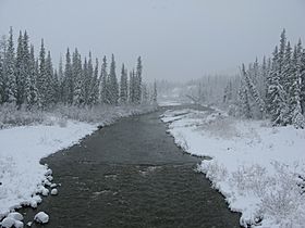
The Gregg River from Alberta Highway 40
|
|
| Country | Canada |
| Province | Alberta |
| Physical characteristics | |
| Main source | Gregg River Headwaters 1,489 m (4,885 ft) 53°07′20″N 117°28′44″W / 53.12222°N 117.47889°W |
| River mouth | McLeod River 1,161 m (3,809 ft) 53°17′28″N 117°16′52″W / 53.29111°N 117.28111°W |
The Gregg River is a small river located in the western part of Alberta, Canada. This river got its name from John James Gregg, who lived from 1840 to 1941. He was a well-known prospector (someone who searches for valuable minerals) and trapper (someone who catches animals for their fur) in the area.
Where the Gregg River Flows
The Gregg River starts when several smaller creeks join together. This happens near the Cardinal River Coal Mine, at the bottom of a mountain called Mount Sir Harold Mitchell.
From there, the river flows towards the northwest. As it travels, more small streams, called tributary creeks, flow into it. Eventually, the Gregg River joins a larger river known as the McLeod River. The McLeod River then flows into the even bigger Athabasca River.
You can see the Gregg River if you drive on Alberta Highway 40, as the highway has a bridge that crosses over it.
Smaller Streams Joining the River
Many smaller creeks flow into the Gregg River, adding to its water. These are some of the main ones:
- Berry's Creek
- Sphinx Creek
- Drinnan Creek
- Warden Creek
- Teepee Creek
- Wigwam Creek
 | James Van Der Zee |
 | Alma Thomas |
 | Ellis Wilson |
 | Margaret Taylor-Burroughs |

