Gresham, Nebraska facts for kids
Quick facts for kids
Gresham, Nebraska
|
|
|---|---|
|
Village
|
|

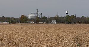
Gresham, seen from the south along
Nebraska Highway 69, October 2011 |
|

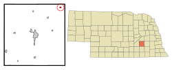
Location of Gresham, Nebraska
|
|
| Country | United States |
| State | Nebraska |
| County | York |
| Area | |
| • Total | 0.27 sq mi (0.70 km2) |
| • Land | 0.27 sq mi (0.70 km2) |
| • Water | 0.00 sq mi (0.00 km2) |
| Elevation | 1,614 ft (492 m) |
| Population
(2020)
|
|
| • Total | 219 |
| • Density | 814.13/sq mi (314.56/km2) |
| Time zone | UTC-6 (Central (CST)) |
| • Summer (DST) | UTC-5 (CDT) |
| ZIP code |
68367
|
| Area code(s) | 402 |
| FIPS code | 31-20225 |
| GNIS feature ID | 2398209 |
Gresham is a small village located in York County, Nebraska, in the United States. In 2020, the village had a population of 219 people. It is a quiet place with a rich history.
Contents
History of Gresham
Gresham was first established in 1887. It was originally named Poston. This happened when the Fremont, Elkhorn and Missouri Valley Railroad built its tracks through the area. When a town is "platted," it means its streets and lots are officially mapped out.
However, there was already another place in Nebraska called Poston. To avoid confusion, the town's name was changed. It was renamed Gresham to honor Walter Q. Gresham. He was an important person who served as the Secretary of State of the United States. The Secretary of State is a top advisor to the President on foreign affairs.
Geography of Gresham
Gresham is located in the state of Nebraska. According to the United States Census Bureau, the village covers a total area of about 0.27 square miles (0.70 square kilometers). All of this area is land, meaning there are no large bodies of water like lakes or rivers within the village limits.
Population Facts
The number of people living in Gresham has changed over the years. Here's a quick look at how the population has grown and shrunk:
| Historical population | |||
|---|---|---|---|
| Census | Pop. | %± | |
| 1900 | 297 | — | |
| 1910 | 344 | 15.8% | |
| 1920 | 492 | 43.0% | |
| 1930 | 442 | −10.2% | |
| 1940 | 352 | −20.4% | |
| 1950 | 267 | −24.1% | |
| 1960 | 239 | −10.5% | |
| 1970 | 248 | 3.8% | |
| 1980 | 320 | 29.0% | |
| 1990 | 253 | −20.9% | |
| 2000 | 270 | 6.7% | |
| 2010 | 223 | −17.4% | |
| 2020 | 219 | −1.8% | |
| U.S. Decennial Census | |||
2010 Census Details
In 2010, the census counted 223 people living in Gresham. There were 94 households, which are groups of people living together in one home. Out of these, 59 were families.
The population density was about 825.9 people per square mile. This means that for every square mile of land, there were about 826 people. There were also 125 housing units, which are homes or apartments.
Most of the people living in Gresham were White (97.8%). A small number were African American (0.4%) or Native American (0.4%). About 1.3% of the population identified as being from two or more races.
Many households (30.9%) had children under 18 living with them. About 45.7% were married couples. Some households (8.5%) had a female head without a husband, and 8.5% had a male head without a wife. About 37.2% of households were not families.
The average age of people in Gresham was 41.5 years old. About 28.3% of residents were under 18. About 14.8% were 65 years old or older. The village had slightly more males (52.0%) than females (48.0%).
Interesting People
- William H. Diers (1890-1982) was a notable person from Gresham. He was a successful businessperson and also a politician. A politician is someone who works in government. Diers served as the Speaker of the Nebraska Legislature in 1939. The Nebraska Legislature is the group of elected officials who make laws for the state of Nebraska. The Speaker is the leader of this group.
See also
 In Spanish: Gresham (Nebraska) para niños
 | Calvin Brent |
 | Walter T. Bailey |
 | Martha Cassell Thompson |
 | Alberta Jeannette Cassell |

