Ground Equipment Facility J-33 facts for kids
Quick facts for kids Ground Equipment Facility J-33(Mill Valley Air Force Station until 1980) |
|
|---|---|
| Part of 1951-1968: 1968-1979: |
|
| Mount Tamalpais West Peak, 3.1 miles (5.0 km) WNW of Mill Valley | |

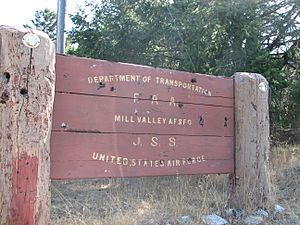
The FAA sign for the facility
|
|
| Coordinates | 37°55′26″N 122°35′49″W / 37.92389°N 122.59694°W |
| Type | Air Route Surveillance Radar |
| Site information | |
| Owner | Marin Municipal Water District |
| Controlled by | Federal Aviation Administration |
| Site history | |
| Built | 1951 |
| In use | 1951-1980 (USAF) 1980-present (FAA) |
Ground Equipment Facility J-33 is a radar station run by the Federal Aviation Administration (FAA). It uses a special radar called an Air Route Surveillance Radar (ARSR-4) to help control air traffic. This facility is part of the Joint Surveillance System's Western Air Defense Sector (WADS).
Before the FAA took over, this site was a USAF radar station. It played an important role during the Cold War, watching for aircraft. The station is located on the West Peak of Mount Tamalpais, in Marin County, California.
Contents
History of the Radar Station
This radar station near Mill Valley was one of 28 stations approved on July 21, 1950. It was part of a large network of radar sites called the Permanent System. This network was built during the Cold War to protect the United States. The construction was managed by the Corps of Engineers for the USAF.
The new station was built on a higher part of an older site. This older site was used during World War II as the Mount Tamalpais Radar Site. It was part of the Aircraft Warning Service.
Mount Tamalpais Air Force Station Begins
The Mount Tamalpais Air Force Station was a military base where the 666th Aircraft Control and Warning Squadron started on January 1, 1951. This squadron began using two AN/CPS-6B radars in late 1951.
The station had a control center that linked different ground-controlled interception radars. On March 10, 1952, a new system was set up to identify planes coming from overseas. On December 1, 1953, Mount Tamalpais AFS was renamed after the nearby community of Mill Valley.
Mill Valley Air Force Station's Role
Mill Valley Air Force Station received a new radar, an AN/FPS-8, in 1955. This radar was later changed to an AN/GPS-3. In 1956, an AN/FPS-4 radar was used to find the height of aircraft. This was later replaced by an AN/FPS-6 in 1958.
In 1960, Mill Valley began using an AN/FPS-7 search radar. This radar was built by the General Electric company in 1959.
Connecting to SAGE
During the time of SAGE, a special system called a Burroughs AN/FST-2 was installed. This system took radar information and turned it into digital data. This digital data was then sent by microwave to the Air Defense Direction Center (DC-18) at Beale Air Force Base. This started happening in late 1960.
The squadron at Mill Valley was renamed the 666th Radar Squadron (SAGE) on January 15, 1961. By 1961, the 666th also added AN/FPS-6 and AN/FPS-6B radars to find aircraft height. A small group from the 666th also operated radars at the Mather AFB P-58 radar station. This station, along with the Fort Ord P-38A, sent radar information to Mill Valley.
NORAD Control Center Operations
Mill Valley AFS became the control center for the San Francisco Defense Area from 1961 to 1974. This was part of the NORAD system. The 40th Artillery Brigade managed the Army Air Defense Command Post here starting in September 1961.
This center helped coordinate defense actions from different missile sites in the San Francisco Metropolitan Area. On July 31, 1963, Mill Valley P-38 was given a new NORAD ID, Z-38.
After the San Francisco Air Defense Sector at Beale closed in 1963, Mill Valley's radar data was sent to Adair AFS in Oregon. In 1964, a new radar, an AN/FPS-26A, replaced the AN/FPS-6. Another radar, the AN/FPS-6B, was changed to an AN/FPS-90.
In 1966, the AN/FPS-26A was changed again to an AN/FSS-7. This radar was used to detect and warn about SLBMs (Submarine-Launched Ballistic Missiles). It was operated by the 3d Missile Warning Squadron and later by Detachment 3 of the 14th Missile Warning Squadron starting July 8, 1972.
The 666th Radar Squadron was closed on September 30, 1980. This happened after the station was transferred to Air Defense, Tactical Air Command (ADTAC) on October 1, 1979. The SLBM radar was also turned off around 1980.
Most of the Mill Valley AFS land was given to the NPS. The radar facilities were given to the FAA. The USAF kept control of one height-finder radar, which was changed to an AN/FPS-116. In 1995, the FAA used an AN/FPS-66A radar. In the late 1990s, this was replaced by an ARSR-4 radar. This ARSR-4 was placed in the old AN/FPS-26A / AN/FSS-7 tower. This was unusual because most ARSR-4 radars are in specially designed towers.
Air Force Squadron and Its Assignments
The 666th Aircraft Control and Warning Squadron started at Mount Tamalpais AFS on November 27, 1950.
- It was renamed 666th Radar Squadron (SAGE) on January 15, 1961.
- It was renamed 666th Radar Squadron on February 1, 1974.
- It was closed on September 30, 1980.
The squadron was assigned to different groups and divisions over the years:
- 542d Aircraft Control and Warning Group, January 1, 1951
- 28th Air Division, February 6, 1952
- San Francisco Air Defense Sector, July 1, 1960
- Portland Air Defense Sector, August 1, 1963
- 26th Air Division, April 1, 1966
- 27th Air Division, September 15, 1969
- 26th Air Division, November 19, 1969 - September 30, 1980
Ground Equipment Facility Today
On December 23, 1980, the USAF announced that the first seven Joint Surveillance System Regional Operations Control Centers were fully ready. This included the center that replaced the Mill Valley NORAD Control Center.
After 1980, the facility was handed over to the FAA. In 1995, the FAA used an AN/FPS-66A radar at J-33. Today, the FAA operates an ARSR-4 radar at the site.
 | Sharif Bey |
 | Hale Woodruff |
 | Richmond Barthé |
 | Purvis Young |


