Guairá Department facts for kids
Quick facts for kids
Guairá
Departamento de Guairá
|
|||
|---|---|---|---|

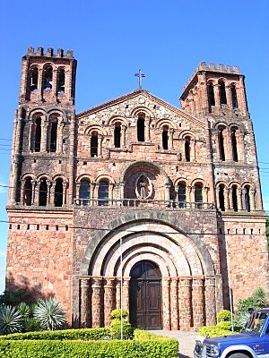
Villarrica's church
|
|||
|
|||

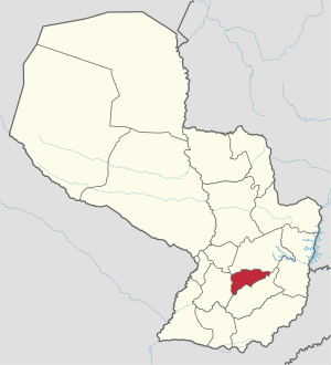
Location of Guairá, in red, in Paraguay
|
|||
| Country | |||
| Region | Oriental | ||
| Capital | Villarrica | ||
| Boroughs | 18 (See list) | ||
| Area | |||
| • Total | 3,846 km2 (1,485 sq mi) | ||
| Population
(2013)
|
|||
| • Total | 198,532 | ||
| • Density | 51.620/km2 (133.696/sq mi) | ||
| Estimated population | |||
| Demonym(s) | Guaireño | ||
| Time zone | UTC-04 (AST) | ||
| • Summer (DST) | UTC-03 (ADT) | ||
| ISO 3166 code | PY-04 | ||
The Guairá department (Spanish: Departamento de Guairá) is an important part of Paraguay. It's like a state or province within the country. Its capital city is Villarrica, which is a well-known place. Guairá has a special code, PY-04, which helps identify it easily.
Contents
Geography
The Guairá department is located in the central part of Paraguay's Oriental region. It's one of the smaller departments in this region and in the whole country. It covers an area of about 3,846 square kilometers (1,485 square miles). In 2013, about 198,532 people lived there. This means that for every square kilometer, there were about 51.6 people.
Where is Guairá?
Guairá shares its borders with other departments:
- To the north: The Caaguazú department.
- To the east: Both Caaguazú and Caazapá departments.
- To the south: The Caazapá department.
- To the west: The Paraguarí department.
 |
Caaguazú department | Caaguazú department |  |
|
| Paraguarí department | Caazapá department | |||
| Caazapá department |
Highest Points in Guairá
Some of the highest points in all of Paraguay are found right here in the Guairá department. These tall peaks include:
- Tres Kandu, which is 842 meters (2,762 feet) high.
- Capii, standing at 816 meters (2,677 feet) high.
- Peró, reaching 815 meters (2,674 feet) high.
- Amor, with a height of 765 meters (2,510 feet).
Rivers of Guairá
The most important river in the department is the Tebicuary. This river flows into the Paraguay River, which is a much larger river. The Tebicuari-mi is another important river that flows into the Tebicuary. A river that flows into a larger river is called a tributary.
Climate and Weather
In 2014, the city of Villarrica received a total of 2,281.8 millimeters (89.83 inches) of rain. The month with the most rain was April, with 453.6 millimeters (17.86 inches). The driest month was August, with only 18.4 millimeters (0.72 inches) of rain.
The average temperature in Villarrica for 2014 was 23°C (73°F). February was the warmest month, with an average temperature of 27.8°C (82.0°F). July was the coolest month, with an average temperature of 17.5°C (63.5°F).
Districts
The Guairá department is divided into 18 smaller areas called districts. Each district has its own local government and communities. Here is a list of these districts, along with their size and population:
| No. | Districts | Area< (km²) |
Population (2015) |
Density |
|---|---|---|---|---|
| 1 | Villarrica | 331.56 | 69,632 | 210.0 |
| 2 | Borja | 349.21 | 10,155 | 29.1 |
| 3 | Capitán Mauricio José Troche | 170.62 | 10,766 | 63.1 |
| 4 | Coronel Martínez | 112.74 | 6,279 | 55.7 |
| 5 | Doctor Bottrell | 77.71 | 1,674 | 21.5 |
| 6 | Félix Pérez Cardozo | 125.86 | 5,999 | 47.7 |
| 7 | General Eugenio A. Garay | 190.95 | 8,228 | 43.1 |
| 8 | Colonia Independencia | 528.44 | 26,525 | 50.2 |
| 9 | Itapé | 157.51 | 7,745 | 49.2 |
| 10 | Iturbe | 328.96 | 9,335 | 28.4 |
| 11 | José Fassardi | 193.51 | 6,857 | 35.4 |
| 12 | Mbocayaty | 247.89 | 8,373 | 33.8 |
| 13 | Natalicio Talavera | 76.69 | 4,708 | 61.4 |
| 14 | Ñumí | 96.01 | 3,507 | 36.5 |
| 15 | Paso Yobái | 629.06 | 25,798 | 41.0 |
| 16 | San Salvador | 109.95 | 3,068 | 27.9 |
| 17 | Tebicuary | 75.22 | 3,013 | 40.1 |
| 18 | Yataity | 84.93 | 4,673 | 55.0 |
Related pages
See also
 In Spanish: Departamento de Guairá para niños
 | Jackie Robinson |
 | Jack Johnson |
 | Althea Gibson |
 | Arthur Ashe |
 | Muhammad Ali |


