Guildhall Village Historic District facts for kids
Quick facts for kids |
|
|
Guildhall Village Historic District
|
|
 |
|
| Location | VT 102, Guildhall, Vermont |
|---|---|
| Area | 39 acres (16 ha) |
| Architectural style | Greek Revival |
| NRHP reference No. | 80000331 |
| Added to NRHP | September 27, 1980 |
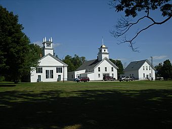
The Guildhall Village Historic District is a special area in the heart of Guildhall, Vermont. It includes the village common (a public green space) and the old buildings around it.
Guildhall was the very first town settled in a part of Vermont called the Northeast Kingdom. It became an important place for business, government, and industry starting in the late 1700s. It's also the shire town (or county seat) for Essex County, which means it's where the main government offices for the county are located. This historic district was added to the National Register of Historic Places in 1980. This list recognizes places important to American history.
Contents
A Look at Guildhall Village History
People first settled in the Guildhall village area in the 1780s. At that time, a dam was built across the nearby Connecticut River. This dam helped power sawmills and gristmills (mills that grind grain into flour).
How the Village Grew
In 1797, a man named Eben Judd owned the mills. He gave land for the village common. He did this to make sure Guildhall would be the main town for the new Essex County. The town itself is named after the Guild Hall. Part of this building was built in 1792. It is the oldest business building in the county.
The first county courthouse was built in 1803. After that, more buildings were added. These included places for government, businesses, churches, and homes. These buildings now stand around the common, which is shaped like a square.
Exploring the Historic District
Guildhall village is located in the northeastern part of the town. It sits on the western bank of the Connecticut River. The historic district is centered around the square common. This common is formed by a curve in Vermont Route 102. This road goes west toward Lunenburg and north toward Maidstone.
Important Buildings and Sites
The common is bordered on the north and west by Courthouse Drive. The district includes all the buildings that face the common. It also stretches a short distance along Vermont Route 102 to the north and west. The river forms the eastern and southern borders of the district.
The district also includes some old industrial sites along the riverbank. One is the remains of a hydroelectric plant. This plant was built in 1921 but was destroyed by fire in 1963. It was located at the western end of the Northumberland Dam. Another site is the remains of the Ward Bailey Gristmill from 1787.
Some of the most important buildings in the district are:
- The county courthouse, built in 1851. It is designed in the Greek Revival style.
- The Congregational church, built in 1844.
- The old jail, the jailer's house, and a barn. These were all built around 1880.
 | Anna J. Cooper |
 | Mary McLeod Bethune |
 | Lillie Mae Bradford |


