
Mount Agung facts for kids
Quick facts for kids Mount Agung |
|
|---|---|

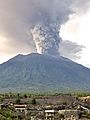
Mount Agung erupting in November 2017
|
|
| Highest point | |
| Elevation | 3,031 m (9,944 ft) |
| Prominence | 3,031 m (9,944 ft) |
| Naming | |
| English translation | Paramount, The Great Mountain |
| Geography | |
| Location | Bali, Indonesia |
| Geology | |
| Mountain type | Stratovolcano |
| Last eruption | 2019 |
| Climbing | |
| Easiest route | Hike |

Mount Agung (also called Gunung Agung) is a huge volcano on the island of Bali in Indonesia. It stands southeast of Mt Batur, another volcano in Bali. Mount Agung is 3,031 metres (about 9,944 feet) tall. This makes it the highest mountain on Bali. It is also the fifth highest volcano in all of Indonesia. Its size affects the weather around it, especially how much rain falls.
Mount Agung is very important to the people of Bali for spiritual reasons. It is home to the 'Mother Temple' called Besakih. The mountain is part of a chain of volcanoes that form the backbone of Bali. An old Balinese story says that the Hindu God Pasupati created Agung. He supposedly split Mount Meru, which is seen as the spiritual center of the universe, and used a piece to form Mount Agung. The most important temple in Bali, Pura Besakih, is located high up on the slopes of Gunung Agung.
Mount Agung is an active volcano. It has a large, deep crater that sometimes lets out smoke and ash. From far away, the mountain looks like a perfect cone shape.
It last erupted in 2019. Before that, there were eruptions in 2017 and 2018.

From the top of Mount Agung, you can sometimes see Mt Rinjani. This mountain is on the nearby island of Lombok to the east. However, both mountains are often covered in clouds.
Contents
History of Mount Agung Eruptions
Mount Agung's eruption in 1963 was one of the biggest in the 20th century. It caused a lot of damage in Bali and other areas of Indonesia. Records of earlier eruptions are not very clear. However, there was definitely an eruption in the 1820s.
1843 Eruption
Mount Agung erupted in 1843. A person named Heinrich Zollinger wrote about it. He said that after being quiet for a long time, the mountain became active again. First, there were earthquake shocks. Then, it started to release ash, sand, and stones.
1963 Eruption
Mount Agung's last major eruption was in 1963. This caused a lot of destruction in eastern Bali. Old Balinese texts say that a very important Hindu ceremony, the Eka Dasa Rudra, should happen every 100 years. This ceremony is meant to purify the world. One was planned for Besakih temple in 1963.
In February 1963, Mount Agung started to rumble. Some high priests thought this was a bad sign from the Gods. They believed the ceremony had been scheduled for the wrong date. But the President of Indonesia, Sukarno, had planned to attend with important visitors. So, he ordered that the event must still happen.
By March 8th, the mountain was getting ready to erupt. On March 18th, it exploded with great force. The top 100 metres (about 328 feet) or more of the mountain were blown away. Lava flowed over much of eastern Bali. A dangerous cloud of gas swept across villages. Ash destroyed all the crops. About 2,000 people died, and tens of thousands of homes were ruined.
Amazingly, the Mother Temple of Besakih, which is high on the mountain's slopes, was not badly damaged. Many local people saw this as a spiritual sign. Some Balinese also believed this eruption was a warning of bad things to come. They felt this was proven true when Indonesia faced a difficult time in 1965. The cleansing ceremonies from 1963 were finally finished at Besakih in 1979.
2017 Seismic Activity and Eruption


- In September 2017, the area around Mount Agung had many earthquakes. There were 844 volcanic earthquakes in total. On September 26, there were 300 to 400 earthquakes in one day. Scientists were worried because other volcanoes have erupted with fewer warning signs.
- Because of the increased rumbling and earthquakes, the alert level was raised to the highest level. About 122,500 people had to leave their homes near the volcano. The Indonesian National Board for Disaster Management set up a 12-kilometer (about 7.5 miles) safe zone around the volcano. People who left their homes stayed in sports halls and other community buildings.
- By late October 2017, the volcano's activity slowed down a lot. So, the highest emergency status was lowered on October 29.
- On November 21, the volcano became active again. A phreatic eruption happened. This is an eruption caused by steam, not new magma. The ash cloud reached about 3,842 metres (about 12,600 feet) above sea level. Thousands of people quickly left the area. More than 29,000 temporary refugees stayed in over 270 nearby places.
- Early on November 25, a magmatic eruption began. This means new magma was coming out. The ash plume rose about 1.5 to 4 kilometers (about 1 to 2.5 miles) above the top of the volcano. It drifted south, covering the area with a thin layer of dark ash. Some airlines canceled flights to Australia and New Zealand. Later that night, an orange glow was seen around the crater. This showed that fresh magma had reached the surface.
- On November 26, another eruption happened. Ngurah Rai International Airport in Bali was closed. This left many tourists unable to fly. Lahars (mudflows caused by volcanic ash and water) were reported south of the volcano. More than 100,000 people within 10 kilometers (about 6 miles) of the volcano were told to leave.
- On November 27, the Indonesian National Disaster Management Authority raised the alert level to "Warning," which is the highest level. They told everyone to stay out of the danger zone. This zone was 8 kilometers (about 5 miles) from the crater. It also included wider areas to the northeast, south, and southeast, up to 10 kilometers (about 6 miles) away.
- In early December, the eruption became weaker. It only released small amounts of steam and smoke.
2018 Eruptions

January
The volcano erupted again on January 11, 2018. It sent out plumes of smoke and ash. However, Bali's international airport was still safe and operating normally. The eruption column rose about 2.5 kilometers (about 1.5 miles) above the mountain.
February
Mount Agung erupted again on February 13, 2018. This was just a few days after it had been declared safe.
Recent Eruption Impact
The 2017 eruption caused about 40,000 people to leave their homes. These people lived in 22 villages around Mount Agung. The eruption also caused nearby airports to close. Lombok International Airport, on the island of Lombok, closed on November 26 but reopened the next morning. It closed again on November 30 and reopened on December 1. Ngurah Rai International Airport in Bali closed on November 27. More than 400 flights were canceled, and about 59,000 passengers were stuck. The airport reopened on November 29. This eruption also caused a drop in tourism in Bali by about 30%.
Landscape
At lower parts of the mountain, there are thick forests. But as you go higher, the trees disappear. The landscape becomes bare volcanic rock and ash. From the top of Mount Agung, the views are amazing in every direction. The view to the east is especially dramatic, where the sun rises over Mount Rinjani on Lombok.
Flora and Fauna
You can find wild pigs and monkeys called macaques on the forested slopes of Mount Agung. There are also many birds, including hawks and eagles. However, they are not as easy to spot as in the West Bali National Park. A pair of monkeys are often seen near the crater rim, above Pura Pasar.
Climate
Mount Agung affects the climate of the area around it. Clouds come from the west, and Agung blocks their water. This means the west side of the mountain is lush and green. The east side, however, is dry and barren.
The best time to climb Mount Agung is during the dry season, from April to October. You should try to avoid climbing in January and February. During these months, there is heavy rain, and there can be floods and even landslides.
At lower elevations, the weather is tropical. But higher up, on the bare rock slopes, it gets very cold and often windy.
Recreation

There are two main paths to climb the mountain. One path starts from Pura Besakih. It goes to the higher western peak and begins at about 1,100 metres (about 3,600 feet) high.
The second path is said to take five hours one-way. It goes to the southern peak and starts higher up from Pura Pasar Agung, near Selat.
Safety for Climbing Mount Agung
No matter how much climbing experience you have, do not try to climb Mount Agung without a guide. The paths are hard to follow, and you could easily get lost. Avoid climbing during the wet season, especially in January and February. Even though you are in the tropics, Mount Agung is a high peak. The top is often cold and windy, so bring warm clothes.
You might experience some mild altitude sickness. This happens when your body has trouble adjusting to higher altitudes. It is important to know the symptoms. You should drink more water than you think you need. Also, avoid drinks like alcohol and caffeine for 24 hours before your climb. At these heights, any symptoms should only be minor.
Tourist Attractions

Pura Pasar Agung is one of Bali's nine important temples. It is located at the start point of one of the climbing routes up Mount Agung. It is near the village of Selat, on the main road from Rendang to Karangasem.
The Sidemen/Selat area is incredibly beautiful. It includes several valleys in the foothills of Mount Agung. The drive through this area is very scenic and one of the best in Bali. Amazing rice terraces, green forested hillsides, and the mountain itself make this a wonderful place to visit. If you stop in the village of Selat, you can easily find local guides for easy hikes in the area.
Besakih Temple
Besakih is known as the Mother Temple of Bali. It is the most important temple for the entire island. Another great thing about Besakih, which is actually a group of temples, is its amazing location on the southern slopes of Mount Agung.
Images for kids
-
Mount Agung erupting on 27 November 2017
See also
 In Spanish: Monte Agung para niños
