Hampton, Maryland facts for kids
Quick facts for kids
Hampton, Maryland
|
|
|---|---|

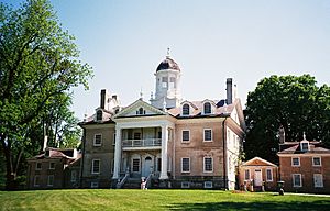
The Hampton National Historic Site in Hampton, Maryland
|
|

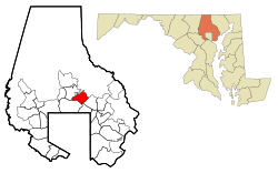
Location of Hampton in the State of Maryland
|
|
| Country | |
| State | |
| County | |
| Area | |
| • Total | 6.35 sq mi (16.45 km2) |
| • Land | 5.95 sq mi (15.41 km2) |
| • Water | 0.40 sq mi (1.04 km2) |
| Elevation | 338 ft (103 m) |
| Population
(2020)
|
|
| • Total | 5,180 |
| • Density | 870.44/sq mi (336.08/km2) |
| Time zone | UTC-5 (Eastern (EST)) |
| • Summer (DST) | UTC-4 (EDT) |
| ZIP codes |
21286
|
| Area code(s) | 410 / 443 |
| FIPS code | 24-36512 |
| GNIS feature ID | 0590409 |
Hampton is a special kind of community in Baltimore County, Maryland, United States. It's called a census-designated place (CDP), which means it's an area that the government counts for population, but it's not officially a city or town.
In 2020, about 5,180 people lived in Hampton. It's often seen as part of the nearby community of Towson. Hampton is just north of Baltimore, about a 20-minute drive from the city center.
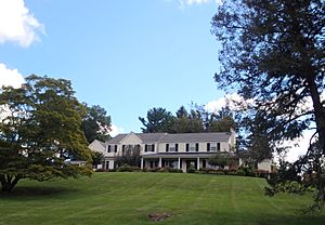
Hampton has homes on large plots of land, making it feel like a park. A main landmark here is the Hampton National Historic Site. The Towson United Methodist Church is also in Hampton, near I-695 and Goucher College.
Contents
History of Hampton
Early Days and Land Ownership
Long ago, Native American tribes like the Susquehannock often visited this land. They used a path that is now Joppa Road.
The area we know as Hampton today was first given as a special land grant in 1695. It went to a family member of Lord Baltimore. His family later sold the land in 1745 to Charles Ridgely. He was a tobacco farmer and trader.
The Hampton Mansion and Its Legacy
In the late 1700s, the Ridgely family built the Hampton Mansion. They used the land around it for farming. They grew apples and raised race horses.
The Ridgely family owned the land for many generations. In 1929, the Hampton Development Company was created. This company divided the land around the mansion into smaller plots. This is how the modern Hampton community began.
The Ridgely family kept the Hampton Mansion until 1948. Then, the house and its remaining 43 acres (17 hectares) became a National Historic Site. It was sold to a group that wanted to protect it. Today, the National Park Service takes care of it.
Towson United Methodist Church in Hampton
In 1958, the Towson United Methodist Church finished building its large church in Hampton. It has a Georgian style and a tall spire that is 235 feet (72 meters) high. The church is on 16 acres (6.5 hectares) of land.
In 2008, the church planned to sell about 5 acres (2 hectares) of undeveloped land. A developer wanted to build homes for older adults there. This would have meant changing the rules to allow more homes per acre.
However, the Hampton Improvement Association, which represents people living in the neighborhood, did not agree. They said they "oppose zoning changes that would allow higher density residential development and require trees to be knocked down". The church then decided not to go ahead with the plan. They wanted to remain a good neighbor to the community. Now, the church has a walking path in the wooded area. It is open to everyone during the day for quiet walks.
Geography and Climate
Where is Hampton Located?
Hampton is located at coordinates 39°25′22″N 76°35′5″W.
The United States Census Bureau says that Hampton covers a total area of 5.7 square miles (14.8 square kilometers). All of this area is land.
Hampton's Climate
The weather in Hampton has hot, humid summers. The winters are usually mild to cool. According to the Köppen Climate Classification system, Hampton has a humid subtropical climate. This is often shown as "Cfa" on climate maps.
Population and People
| Historical population | |||
|---|---|---|---|
| Census | Pop. | %± | |
| 1980 | 5,220 | — | |
| 1990 | 4,926 | −5.6% | |
| 2000 | 5,004 | 1.6% | |
| 2010 | 5,052 | 1.0% | |
| 2020 | 5,180 | 2.5% | |
| U.S. Decennial Census | |||
In 2000, there were 5,004 people living in Hampton. There were 1,900 households and 1,578 families. The population density was about 876 people per square mile (338 people per square kilometer).
Most people in Hampton were White (91.41%). There were also African American (1.48%) and Asian (6.00%) residents. About 1.48% of the population was Hispanic or Latino.
About 29.1% of households had children under 18 living with them. Most households (75.3%) were married couples living together.
The median age in Hampton was 48 years old. This means half the people were older than 48 and half were younger. About 21.9% of the population was under 18. And 24.5% were 65 years or older.
The median income for a household in Hampton was $95,546. For families, it was $100,240. The average income per person was $43,850. A small number of families (0.4%) and people (1.8%) lived below the poverty line.
Schools in Hampton
Hampton is served by several public schools:
- Hampton Elementary
- Cromwell Valley Elementary (Magnet)
- Ridgely Middle School
- Loch Raven High School
- Towson High School
There are also two private schools in Hampton:
- Notre Dame Preparatory School: A Catholic school for girls.
- Concordia Preparatory School: A Lutheran school for both boys and girls.
See also
 In Spanish: Hampton (Maryland) para niños
 | Delilah Pierce |
 | Gordon Parks |
 | Augusta Savage |
 | Charles Ethan Porter |


