Hann Range facts for kids
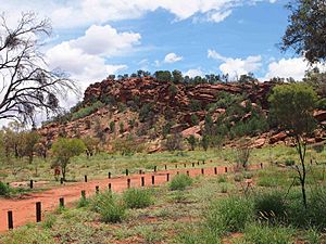
The Hann Range is a mountain range found in the Northern Territory of Australia. It is located in central Australia, about 120 kilometers (75 miles) north of Alice Springs. This range is an important natural area.
Contents
About the Hann Range
The Hann Range stretches from east to west for about 40 kilometers (25 miles). It is surrounded by a flat area called the Burt Plain. The highest point in the Hann Range is a peak called Mount Evatt. It stands tall at 802 meters (2,631 feet) above sea level. The main road, the Stuart Highway, cuts right through the range near Mount Evatt.
What the Range is Made Of
The Hann Range sits in an area known as the Ngalia Basin. It is mostly made of strong, brown sandstone. This sandstone forms a clear ridge. It lies on top of older, deeper rocks. The rocks here are similar to the strong quartzite rocks you can see near Alice Springs.
Traditional Owners and Sacred Sites
The traditional owners of the Hann Range area are the Arrernte people. They have lived here for a very long time. They call this special place Arwerlt Atwaty.
Native Gap Conservation Reserve
Inside the Hann Range, you will find the Native Gap Conservation Reserve. This gap is a very important sacred site for both the Arrernte people and the Anmatyerr peoples. It is a place where many creation stories come together. These stories explain how the world and everything in it was created.
The name of the site in the Arrernte language is Arurlte Artwatye. Arurlte means 'the top of the shoulders across the neck'. Artwatye means 'gap'. So, the name describes the shape of the land.
How the Hann Range Got its Name
The Hann Range was likely named in 1870. An explorer named John Ross was surveying a route for the Overland Telegraph. He probably named the range after two other explorers and pastoralists, Frank and William Hann.
 | Janet Taylor Pickett |
 | Synthia Saint James |
 | Howardena Pindell |
 | Faith Ringgold |


