
Harbor Hill Moraine facts for kids
The Harbor Hill Moraine is a long, hilly ridge that runs across Long Island. Think of it like a natural "backbone" for the island! It's the more northern of two main ridges that were formed by ancient glaciers.
This special landform was created by the last big ice sheet, called the Wisconsinian glaciation. About 18,000 years ago, this giant glacier reached its farthest point south. As the glacier slowly melted and retreated, it left behind huge piles of rock, sand, and dirt. These piles are what we call moraines. The Harbor Hill Moraine is a terminal moraine, which means it marks the very edge where the glacier stopped.
The glacier finally left the Long Island area completely between 13,000 and 12,000 years ago. The Harbor Hill Moraine is named after Harbor Hill in Roslyn, New York, which is the highest point in Nassau County.
Contents
How Glaciers Shaped Long Island
Imagine a giant river of ice, miles thick, slowly moving across the land. This is what a glacier is! As these massive ice sheets move, they act like giant bulldozers. They pick up and push along huge amounts of soil, rocks, and boulders.
When a glacier stops moving forward, or when it melts faster than it moves, it leaves all that material behind. This pile of debris forms a ridge or a hill called a moraine. The Harbor Hill Moraine is one of these big piles left by the Wisconsinian glacier.
Two Main Ridges: Harbor Hill and Ronkonkoma
Long Island actually has two main glacial ridges. The Harbor Hill Moraine is the northern one. South of it, there's an older ridge called the Ronkonkoma Moraine. The Ronkonkoma Moraine was formed by an even earlier part of the same glacier.
The Harbor Hill Moraine runs along the North Shore of Long Island. You can see parts of it in the North Fork area of eastern Long Island. It also extends to islands like Plum Island, Great Gull Island, and Fisher's Island.
Where the Ridges Meet
The two moraines, Harbor Hill and Ronkonkoma, meet near Lake Success. East of the lake, you can clearly see both ridges. However, west of Lake Success, the Harbor Hill Moraine actually pushed over and covered up the Ronkonkoma Moraine.
South of these moraines, the land flattens out into what's called an outwash plain. This plain was formed by water flowing out from the melting glacier, carrying sand and gravel. This plain slopes down towards the Atlantic Ocean. Over time, as ocean levels rose after the Ice Age, much of this outwash plain became covered by the sea.
Long Island's Water Divide
The Harbor Hill Moraine is very important for how water flows in Nassau County. It acts like a major natural dividing line for streams and rivers.
- Streams and rivers on the northwest side of the moraine flow into Long Island Sound.
- Streams and rivers on the south side of the moraine flow into the series of bays and sounds behind the barrier islands, eventually reaching the Atlantic Ocean.
Images for kids
-
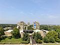
Harbor Hill and the Harbor Hill Moraine, as seen from the Axinn Library at Hofstra University in September 2021. Harbor Hill is visible towards center-right.

