Hardscrabble Pass facts for kids
Quick facts for kids Hardscrabble Pass |
|
|---|---|

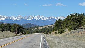
Looking west towards the Sangre de Cristo Mountains from the top of the pass.
|
|
| Elevation | 9,085 ft (2,769 m) |
| Traversed by | State Highway 96 |
| Location | Custer County, Colorado, United States |
| Coordinates | 38°09′52″N 105°17′00″W / 38.16444°N 105.28333°W |
Hardscrabble Pass is a special place in the mountains of Colorado, USA. It is a mountain pass, which is like a natural pathway through a mountain range. This pass sits at a high elevation of 9,085 feet (2,769 meters) above sea level.
It connects different parts of Colorado. To the west, you'll find the Wet Mountain Valley. To the east, there's the valley of the Arkansas River. The pass itself goes right through the Wet Mountains, which is a mountain range in the area.
Exploring Hardscrabble Pass
A road called State Highway 96 travels right over Hardscrabble Pass. This highway connects two towns: Wetmore on the east side and Westcliffe on the west side. Driving over the pass offers amazing views of the surrounding nature.
A Scenic Journey
Hardscrabble Pass is also part of something called the Frontier Pathways Scenic and Historic Byway. This is a special road that people like to drive on to see beautiful sights and learn about history. It's a great way to explore the area.
Nature's Home
The pass is located within the San Isabel National Forest. This means it's part of a large protected area of forests and mountains. National Forests are important for wildlife and offer many outdoor activities like hiking and camping.
 | Roy Wilkins |
 | John Lewis |
 | Linda Carol Brown |

