Harmar, Marietta facts for kids
Quick facts for kids |
|
|
Harmar Historic District
and Boundary Increase |
|

Aerial view, looking west
|
|
| Location | Roughly bounded by the Ohio and Muskingum Rivers and the rear property lines of Lancaster, George, and Franklin Sts.; also roughly bounded by Lancaster, Harmar, Putnam and Franklin Sts. and the Ohio River, Fort Harmar Dr., and the Muskingum River, Marietta, Ohio |
|---|---|
| Area | 60 acres (24 ha); 147.5 acres (59.7 ha) |
| Built | 1785 |
| Architectural style | Federal, Greek Revival, Gothic Revival, Late Victorian |
| NRHP reference No. | 74001645; 93000987 |
| Added to NRHP | December 19, 1974; September 16, 1993 |
Harmar is a special old neighborhood in Marietta, Ohio. It sits where the Muskingum and Ohio Rivers meet. This area grew up around an old fort called Fort Harmar in the 1780s.
Harmar was first part of Marietta. Then, for a while, it was its own separate town. But in 1890, it rejoined Marietta. Today, a bridge connects Harmar to the rest of the city. Many of its old buildings and streets from the 1800s are still there. Most of Harmar is now a historic district. This means it is a protected area on the National Register of Historic Places.
Contents
Harmar's Early History
The first settlers came to Marietta in April 1788. They built cabins and started farms along the river. Many lived on the east side of the Muskingum River. This was across from Fort Harmar. Soldiers at the fort often watched their farming. Sometimes, going across the river was dangerous. One early settler was attacked near the fort.
Becoming a Town
Until 1800, neither side of the river had a clear legal status. Then, a law made both sides part of the town of Marietta. This happened on January 1, 1801.
Years later, people in Harmar wanted to be separate. They had disagreements with Marietta's leaders. So, on January 5, 1837, Harmar became its own town. It was called Point Harmar. But the people of Harmar didn't like all the new rules. They voted to change many parts of the law. A new law was then made to fit their wishes.
This separation lasted until 1890. In that year, Harmar and Marietta joined together again. Harmar also had its own school district from 1866 until 1890.
Harmar's Landscape and Buildings
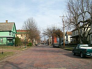
Harmar is a great example of how Ohio towns were planned in the 1800s. Its streets are laid out in a grid plan. This means they run straight north-south and east-west. They do not follow the curve of the rivers. The streets are wide and lined with trees.
Architectural Styles
The houses in Harmar show many building styles from the 1800s. The most important styles are:
- Federal
- Greek Revival
- Gothic Revival
Other common styles include Colonial Revival and Italianate.
Bridges and Roads
Since 1880, Harmar has been connected to Marietta by a bridge. This first bridge was destroyed in a big flood in 1913. A new swing bridge was built in its place. This bridge could swing open for boats. Today, a newer bridge, the Putnam Street Bridge, opened in 2000.
State Route 7 used to go through Harmar. But a new bridge, the Washington Street Bridge, opened nearby. This allowed the highway to be moved away from Harmar's main bridge.
Harmar as a Historic District
In 1974, about 60 acres of Harmar became a Historic District. This means it's a special area protected for its history. It was added to the National Register of Historic Places. Forty-two buildings, the old fort site, and one other item were part of this district. These are called "contributing properties" because they add to the district's historical importance.
Expanding the District
In 1993, the district grew much larger. More than 200 new contributing properties were added. The area expanded to about 150 acres. The first district protected areas closer to the old fort. The newer addition included areas at the edges of the neighborhood.
Not all of the original contributing properties still exist. For example, the old Putnam Street Bridge was part of the district. But it was replaced. The new bridge was designed to fit in with the old buildings of Harmar. It also matches the larger Marietta Historic District on the other side of the river.
 | Emma Amos |
 | Edward Mitchell Bannister |
 | Larry D. Alexander |
 | Ernie Barnes |


